Sorry to be so late on the earthquake information. I have just been really swamped. If you are not aware of the big Alaskan Earthquake and associated Tsunami, here is some data on the occurrence and the fallow up. Included is the latest Earthquake update from JCrisp.
DISCLAIMER: In my posts I normally collect a number of written articles and videos related to the topic. I hightlight in red or black the parts of the articles that I think are important to note and try to leave it to the reader to come to their own conclusions. The object is to bring the facts/truths to your attention and cause you to look further into them yourself. Why? Because that is the only way to make the subject real to you. When you view the available information, search it our on your own, hopefully guided by the Holy Spirit, YOUR CONCLUSION is exactly that YOURS. It means something to you. It may be similar to mine or it may be completely different. We are all on our own course and in different places with our spiritual development. I pray that GOD speaks to you in a way that touches you. IF you see notes in green, those are my comments. Anything else, you find the source links on the titles, and the author and date will be below the titles. Just because I post an article or video in my articles, it does not mean that I agree with the author or support their stand. It does mean that I felt there was worthwhile information to be gleaned.
![]()
Alaska Earthquake Revised up to Magnitude-7.6
Officials say the magnitude of the earthquake that struck off the Alaska Peninsula and produced a tsunami with small waves has been revised up to a 7.6.

A biker leads a line of cars driving off the Homer Spit at about on Monday, Oct. 19, 2020, in Homer, Alaska after a tsunami evacuation order was issued for low-lying areas in Homer. (Michael Armstrong/Homer News via AP) THE ASSOCIATED PRESS
JUNEAU, ALASKA (AP) — The magnitude of the earthquake that struck off the Alaska Peninsula and produced a tsunami with small waves was revised up to 7.6, officials said Tuesday.
The quake Monday was first reported as magnitude-7.4 and was revised to a 7.5 before the latest revision. There was no major damage from the quake or tsunami.
Different agencies also can report varying distances from the quake to nearby communities because earthquakes occur over a wide geographic area, said Michael West, director of the Alaska Earthquake Center.
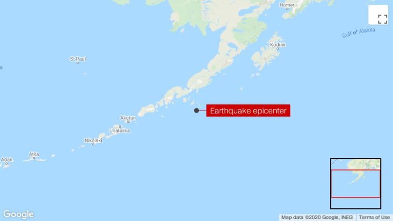
The quake struck in the Pacific Ocean, centered about 67 miles (118 kilometers) southeast of Sand Point, according to the Alaska Earthquake Center.
Sand Point is about 800 miles (1,288 km) southwest of Anchorage. The earthquake was felt widely in communities along the southern coast, including Sand Point, Chignik, Unalaska and the Kenai Peninsula, according to the center.
The quake produced a tsunami, and a warning was issued for about a thousand-mile stretch of the southern Alaska coast. The warning downgraded to an advisory just over two hours after the earthquake struck, and the advisory was lifted late Monday. Waves topped 2 feet (1 meter) in some areas, according to the National Tsunami Warning Center.
Copyright 2020 The Associated Press. All rights reserved. This material may not be published, broadcast, rewritten or redistributed.
spacer
Small tsunami generated by magnitude 7.5 earthquake that prompted evacuation orders
(CNN)The magnitude 7.5 earthquake near Sand Point, Alaska, generated a tsunami, Scott Langley with the National Tsunami Warning Center said Monday afternoon.
Langley said the tsunami sent two waves, each measuring 130 centimeters (4 feet, 3 inches) high. But observers onshore reported the waves appeared to be 1.5 feet (45.7 centimeters) and 2 feet (61 cm) over high tide.The center is monitoring harbors in a 500-mile area along the Alaska coastline, he said.Tsunami advisories issued for parts of Alaska and the state of Hawaii following the earthquake were canceled Monday night, according to tweets from the National Weather Service Pacific Tsunami Warning Center (NWS PTWC).Langley said earlier the area in Alaska that had been subject to the warning and advisory is “pretty remote.”“For other US and Canadian Pacific coasts in North America, there is no tsunami threat,” the center said.
The earthquake’s epicenter was recorded less than 60 miles from Sand Point, near the Aleutian Peninsula in the southwestern part of the state.“We did feel it,” Sand Point Clinic employee Lorna Osterback said of the quake. “This is a big one.”Osterback said residents of the town would be heading to higher ground away from the shoreline as they wait out the tsunami threat.“We expect we will have another one in about half an hour,” noted Osterback. “We’re right on the fault line. I grew up here and it’s kind of normal.”Jeanette Piniones Navales moved her family from Kodiak Island to higher ground on Pillar Mountain when the tsunami alerts sounded Monday. She said she has lived in Kodiak since 2014 and this is her sixth time experiencing a tsunami warning.“I got nervous and immediately convinced my family to move (to) high ground to be safe,” she told CNN.Candace Nelson, her kids and dogs hid under the table as the earthquake shook Cold Bay, about 90 miles west of Sand Point.“My kids are all doing good. Brooke, Wilder and Scout all huddled under our kitchen table till the shaking stopped,” she told CNN as the family waited for more news about the tsunami. “The dogs were more concerned as to what the heck we were doing under the table.”Residents of Homer could also be seen driving to higher ground after being given evacuation orders.
A line of traffic leaves Homer, Alaska, after a tsunami evacuation order was issued for low-lying areas.Several aftershocks, including one with a magnitude of 5.9 and one that was 5.8, struck in the hour after the big quake.

spacer
10-21-20 Quake News & Updates
Thank you to all who sent e-mails inquiring whether we were okay and to express your concerns and prayers. I apologize for the lack of updates and breaking news bulletins the past three days. I am typically on top of all major quakes and punctual in getting out the updates. What happening in the past three days is that the sheer volume of e-mails going out to subscribers overwhelmed my local internet provider’s bandwidth, which prevented me from being able to send out group e-mails on the big M7.5 Alaska quake and the new Iceland swarm as well as any updates on the New Madrid seismic zone. It’s been frustrating with my hands tied, waiting for them to fix it, so after working on it all day yesterday, today I finally got a new dedicated e-mail watchman@earthquakeforecasting.net and am now working on creating a website to help streamline subscriptions and information dissemination. I will keep you informed as to when the new website is up and running.
So, the bad news is I couldn’t communicate the important information about earthquakes in a timely fashion, but the good news is that a new website and e-mail address should make for better communications and save me time and headaches. I’m not computer savvy with technical aspects, so I have a friend helping me get things set up.
Welcome aboard to the latest group of subscribers. I’ve sent out an introductory letter with background information and several recent bulletins and back issues to get you up to speed.
You’ll find updates on the Alaska quake, Iceland quake, and New Madrid situation in the Earthquake Forecasting Principles section of tonight’s update, because each of these events deals with indicators and clues to forecast future quakes.
The Prep Tips section in tonight’s update has an interesting game that uses one nail. How can a nail help you survive a natural disaster? Read and find out!
Attached is the current issue of the Quake News & Updates.
Watch and see!
The Watchman
watchman@earthquakeforecasting.net
10-21-20 Quake News & Updates __________
Earthquake Activity:
In the last three days we have seen VERY HIGH seismic activity across the world,
with a total of 25 earthquakes at or above M5.0, including a M7.5 quake off the coast of
Alaska.
A total of 19 DEEP (200+ km) earthquakes have been recorded worldwide over the
last three days, which is HIGH.
• Largest earthquake to strike in the U.S. (including U.S. territories): M7.5
• Largest earthquake to strike in Kansas since the previous update: M3.3
• Largest quake elsewhere in the world since the previous update: M5.9Summary: The M7.5 Alaska quake occurred in an area that has been hit by multiple
M5.9-7.8 quakes. USGS says it is an aftershock from the July 22 M7.8 quake. A
tsunami WARNING was issued but it was downgraded to an advisory soon after.WATCHES & WARNINGS: imminent threats for large earthquakes or tsunamis
• The WARNING time frame has been revised for a large earthquake with a top-end
potential in the M5.6-6.4 (6.6) range to strike off the coast of the Pacific Northwest,
along the Juan de Fuca fracture zone, most likely off the coast of southern Oregon
in the next 7-10 days (extended). I obviously “jumped the gun” so to speak in the
original forecast time frame. The big M7.5 Alaska quake is now influencing the
time frame. If this forecasted quake strikes as expected, California should be on
ALERT for multiple M5.0-6.0 range quakes in central and southern parts of the
state occurring within a few days following the expected large quake off the coast.
• The WARNING has now been downgraded to a WATCH for the New Madrid
seismic zone for a possible large quake with a high-end potential in the M4.9-7.9
(8.2) range in the next 14 days (by Nov. 4). The threat of a large quake remains
viable, but the time frame may no longer be imminent. Very few hot spots have
appeared in the region the past several days. Please do not dismiss the potential for
a large quake to occur, because eventually it will. Continue to prepare and be aware.
Use the extended time to acquire the necessary supplies and consider the possibility
of moving out of the danger zone if you are in the direct line of fire, especially in
and around Memphis.Long Term Continuous WATCHES: (no specified time frame given as yet)
Earthquakes – U.S.
• Pacific Northwest – Cascadia mega-thrust quake – M8.6-9.2 range with tsunami
• Garlock and/or San Andreas faults in southern California – M7.9-8.4 range
• New Madrid seismic zone in southeast Missouri – M7.7-8.2 range.
Volcanoes – U.S. (9 out of 10 are ranked by USGS in the top 20 as “very high risk”
• Kilauea in Hawaii – explosive blow-out eruption – M6.9-7.2 range
• Mauna Loa in Hawaii – explosive blow-out eruption – M6.9-7.9 range
• Mount Saint Helens in Washington – explosive eruption – M5.9-6.9 range
• Mount Rainier in Washington – major eruption with lahars – M5.9-6.9 range
• Mount Baker in Washington – major eruption – M5.9-7.2 range
• Mount Hood in Oregon – major eruption – M5.9-7.2 range
• Mount Shasta in California – moderate eruption – M5.9-6.6 range
• Mount Lassen in California – moderate eruption – M5.9-6.6 range
• Long Valley Caldera in California – major eruption – M6.6-7.7 range
• Yellowstone in Wyoming – moderate to major eruption – M7.2-8.2 range
Swarms: (swarms now occurring and highest magnitudes in the past three days)
Major swarms continue in California, Nevada, Hawaii, Mexico, Puerto Rico, and
New Zealand. Smaller swarms continue at Yellowstone and in California, including
at The Geysers (N), Mammoth Lakes (EC), and near Salton Sea (S).• Nevada: 15 quakes; reaching a high of M3.2. [Typical.]
• Idaho: 14 quakes; reaching a high of M3.3. [Typical.]
• Hawaii: 38 quakes; reaching a high of M3.1. [Typical.]
• Puerto Rico: 34 quakes; reaching a high of M3.4. [Typical.]
• Southern Mexico: 91 quakes; reaching a high of M4.3. [Typical.]
• New Zealand (48 hrs.): 116 quakes; reaching a high of M4.6. [Typical.]Pacific Northwest Tremor WATCH:
Tremors in the Pacific Northwest continue. Today, there was a medium cluster of
tremors located northwest of Portland, Oregon and a small cluster southwest of Redding, California, with a cumulative total of 134 epicenters. Yesterday, there were five clusters located from south of Vancouver Island down across the Olympia Peninsula, and extending on down to Redding, California, with a cumulative total of 170 epicenters.
You can track Pacific Northwest tremors here: https://pnsn.org/tremor
When the tremors completely stop, then I will issue a WARNING for a potential very large quake with a top end potentially reaching M8.6-9.2 (mega-quake range) to strike off-coast within 10-15 days. A catastrophic tsunami will occur at this magnitude range, with all coastal areas being totally inundated. Waves could reach 60 -100 ft. in height. One or more volcanoes in the Cascadia range could be triggered to erupt as a result of this coming mega-quake and have done so in the past.
Be aware that a large quake may occur without any specific warning. This region is
overdue for a very large earthquake. The last known mega-quake in the region occurred in 1700. When (not if) a mega-quake occurs on the Cascadia, there will be tens of thousands of casualties. The majority of deaths will be caused by a massive tsunami striking the coast. A conservative estimate for mortalities in the event of a full-rip mega-quake is approximately 15,000-20,000 people. These numbers do not reflect injuries or numbers of people left homeless and may be vastly underestimated. Government experts have almost always underestimated casualty figures in major disasters. For more detailed information, request my Special Report: The Coming Big One.Rare Quakes:
These are earthquakes occurring in “divers places,” (i.e. diverse, different, various
locations) where earthquakes rarely occur, or quakes that are of a far higher magnitude than
what is typical for the region.
• None to reportVolcanic Activity:
Worldwide volcanic activity is at HIGH levels the past three days, with a total of 15
volcanoes actively erupting, producing 50 new emissions or eruptions today and 34
yesterday. [The typical number of volcanoes erupting over a three-day period is 12-13,
while the typical number of volcanic emission/eruption reports is 32-33.]Yellowstone Status:
The Yellowstone super volcano region remains active. Earthquake magnitudes the
past three days in the region have reached M3.3 (Idaho).
All indicators suggest that a moderate to major eruption will occur at Yellowstone in the
not-too-distant future, but an eruption does NOT appear to be imminent.
A major buildup of seismic activity is expected to occur weeks to months BEFORE any
major eruption occurs at Yellowstone. We should also expect to see: 1) a significant rise
in temperatures in the hot springs, rivers, and ground surface, 2) an increase in the “die off”
of vegetation inside the caldera, 3) increased ground deformation, 4) increased geyser
activity, 5) regular repeated seismic drumbeats 1-2 minutes apart at shallow depths, and 6)
an increase in harmonic tremors. While all these things have happened before, we should
see a significant and accelerated increase across the board in all these things prior to any
major eruption event.
What may begin as a moderate eruption, similar in size to the Mount St. Helens eruption
in 1980, could, in a worst-case scenario, lead to a major catastrophic super-eruption with
multiple vents, affecting most of the continental U.S. and beyond.EARTHQUAKE REPORTS: new earthquakes occurring since the last update
USA – All M2.5 and greater earthquakes Directional portion of the state indicated in ( ).Magnitude Location
ALASKA:
M7.5, M5.9, M5.8, M5.6, M5.5, (2) M5.2, M5.1, M5.0, (4) M4.9, (4) M4.8, (3) M4.7, (2) M4.6,
(3) M4.5, (2) M4.4, (3) M4.3, (2) M4.2, (3) M4.1, (2) M4.0, (2) M3.9, (3) M3.8, (3) M3.7, (2)
M3.6, M3.5, (4) M3.4, M3.3, etc. Off coast, south of Alaska Peninsula (SW)
M4.8 Off coast, Unimak Island, Aleutians (SW)
M3.8 NW of Juneau (SE)
M3.4 SE of Prudhoe Bay (N)
M3.0 Cook Inlet (S)
M2.5 SW of Mt. McKinley (C)CALIFORNIA:
M4.0, M3.1, M2.9 North of Ukiah (N)
M3.6, M3.5 East of Barstow (S)
M3.4 SW of Salton Sea (S)
M2.9, M2.6 West of Sacramento (N)
M2.6 NE of Ridgecrest (EC)OKLAHOMA:
M3.4 West of Perry (N)
KANSAS: All M2.3 and greater quakes reported with specs.
Oct. 20 2:44 p.m. M3.3 Harper county 5.5 mi. NE of Anthony
Oct. 20 12:33 a.m. M2.4 Dickinson county 3 mi. NE of Hope (EC)
Oct. 21 4:25 a.m. M2.4 Butler county 6 mi. south of Burns (C)
A M2.2 quake also struck in Kingman county. USGS failed to report the Kingman, Butler, and
Dickinson county quakes and under reported the Harper county quake by a half magnitude.
USGS typically fails to report approximately 90% of all Kansas quakes.OTHER U.S. & NEARBY REGIONS: If the region is specifically named as a
target in the current earthquake forecast, there is a check mark (√) in front of it.Gulf of California M4.6, M4.0 Southern Gulf (S)
Baja of California M3.7, M3.2 Northern Baja (N)
Puerto Rico 34 quakes to M3.4 [S] Off coast, south of Puerto Rico (S)
Yellowstone 15 quakes to M3.3 [S] South central Idaho (C)
Nevada 15 quakes to M3.2 [S] West of Tonopah (SW)Hawaii 38 quakes to M3.1 [S] Island of Hawaii (S)
Texas M3.0, M2.5 NW of Pecos (W)
Washington M2.6 North of Portland, Oregon (S)
Arizona M2.6 NW of Flagstaff (NW)International – All M4.9 and greater earthquakes occurring worldwide since the last update.
Deep earthquakes (over 200 km) are designated with the letter “D” following the magnitude. If the
region is specifically named as a target in the current forecast, there is a () in front of it.Sumatra M5.9, M5.5, M5.1, M5.0 Off coast, central Sumatra (C)
Tonga M5.9, M5.0 Off coast, NE of Tonga (NE)
Mariana Islands M5.7, M4.9 Off coast, north of Guam (N)
Chile M5.7 Offshore, Antofagasta (N)
Iceland M5.5 Near Reykjavik (SW)
Ionian Sea M5.2 Off coast, SW of Greece (SW)
Banda Sea M5.2 Off coast, NE of East Timor (NE)
South Shetland Islands M5.1 Off coast, west of S. Sandwich Islands (W)
China M5.1 Sichuan (SC)
Central Mid-Atlantic Ridge M4.9 Off coast, NE of Brazil (NE)
Papua New Guinea M4.9 SW New Britain (E)
South Africa M4.9 Off coast, south of South Africa (S)NOTE: 96.7% (29 of 30) of the world’s largest earthquakes that struck in the past
three days were specifically named by region and were forecasted BEFORE they
occurred, as indicated by the checkmarks above (). See the Earthquake Forecasts
below for proof.EARTHQUAKE FORECASTS: (1 day; 7 days)
The highest magnitude quake in each region is highlighted in yellow. Red font indicates potential M7.0+ magnitude. The parenthesis above indicates number of days left in the two overlapping forecasts. Blue font below indicates the most recent forecast or updated magnitudes. The number inside the () below indicates the highest potential forecast magnitude. Actual magnitudes indicate the highest magnitude quake to strike the forecast target region.
Region Forecasted Magnitude Range Actual USA Blue font represents newest forecast areas and/or recently updated magnitudes.
1. Aleutian Islands – Alaska Peninsula M4.8-5.8 (6.4) M7.5
2. Aleutian Islands – Alaska Peninsula M4.6-5.6 (6.0) M5.9
3. Northern – Central Alaska M3.4-4.2 (4.4) M4.0
4. Northern – Central Alaska M3.4-4.6 (4.9) M3.5
5. Southern Alaska M4.4-5.0 (5.4) M4.5
6. Southern Alaska M4.4-5.8 (6.0) M3.8
7. Washington M2.3-4.3 (4.9) M2.3
8. Washington M2.3-4.9 (5.2) M2.6
9. NW CA – Oregon – Vancouver Island (off coast) M3.8-6.3 (6.4) M2.9
10. NW CA – Oregon – Vancouver Island (off coast) M3.6-6.4 (6.6)
11. Northern California M3.2-4.2 (5.4) M4.0
12. Northern California M3.2-5.4 (6.3)
13. Central California M3.4-4.9 (5.4) M3.2
14. Central California M3.2-5.8 (6.4) M3.0
15. Southern CA – northern Baja/Gulf of California M3.4-5.2 (5.4) M3.6
16. Southern CA – northern Baja/Gulf of California M3.5-5.8 (6.4) M3.5
17. Yellowstone M3.2-4.8 (5.1) M3.5
18. Yellowstone M3.2-4.9 (5.2) M3.0
19. Utah M2.4-3.6 (4.8) M2.6
20. Utah M2.6-4.6 (4.9)
21. Nevada M2.8-3.8 (4.6) M3.1
22. Nevada M2.7-3.7 (4.9) M2.7
23. West Texas M3.0-3.9 (5.9) M3.0
24. West Texas M3.0-4.8 (5.6) M3.0
25. Northern Oklahoma M3.0-3.8 (4.5) M3.4
26. Northern Oklahoma M3.0-4.0 (4.6) M2.7
27. Central Kansas M2.4-3.8 (4.4) M3.0
28. Central Kansas M2.6-3.9 (4.4) M3.3
29. New Madrid, Missouri M2.6-7.7 (8.2) M2.6
30. New Madrid, Missouri M2.6-7.7 (8.2) M2.3
31. Hawaii M3.0-3.6 (4.9) M3.0
32. Hawaii M3.0-3.6 (4.8) M3.0Caribbean
33. Cayman Islands – Cuba – Jamaica – Haiti M3.2-4.4 (4.8) M4.3
34. Cayman Islands – Cuba – Jamaica – Haiti M3.2-4.4 (4.6) M3.2
35. Puerto Rico – Dominican Republic M3.4-4.4 (4.8) M4.9
36. Puerto Rico – Dominican Republic M3.5-4.4 (4.6) M3.2
37. Virgin Islands M3.2-3.8 (4.4) M3.3
38. Virgin Islands M3.2-3.8 (4.2) M3.8
39. Caribbean M4.4-5.4 (5.6) M4.5
40. Caribbean M4.0-5.0 (5.5) M4.9
Mexico – Central America
41. Gulf/Baja of California M4.0-4.6 (5.6) M4.6
42. Gulf/Baja of California M4.0-4.4 (5.4) M4.0
43. Southern Mexico M4.5-5.5 (6.4) M5.5
44. Southern Mexico M4.4-5.4 (6.2) M4.3
45. Guatemala M4.2-5.2 (5.6) M4.5
46. Guatemala M4.2-5.0 (5.6) M4.4
47. El Salvador – Nicaragua M4.4-4.9 (5.9) M4.5
48. El Salvador – Nicaragua M4.4-5.9 (6.2)
49. Costa Rica – Panama M4.2-5.4 (5.9) M3.9
50. Costa Rica- Panama M4.2-5.4 (5.6) M3.7
South America
51. Ecuador – Columbia M4.6-5.9 (6.6) M4.5
52. Ecuador – Columbia M4.6-5.6 (6.2) M5.5
53. Peru M4.6-5.9 (6.9) M4.7
54. Peru M4.6-5.6 (6.6) M5.5
55. SW Bolivia M3.4-4.9 (5.5) M4.2
56. SW Bolivia M3.4-4.4 (5.4) M4.3
57. Northern Chile M4.3-5.3 (5.6) M5.7
58. Northern Chile M4.3-5.2 (5.4) M4.3
59. Central – Southern Chile M4.5-6.4 (6.6) M4.5
60. Central – Southern Chile M4.4-5.6 (6.8) M4.2
61. Northern Argentina M4.4-5.0 (5.4) M4.9
62. Northern Argentina M4.4-4.9 (5.2) M4.5
63. Easter Island M4.7-5.7 (5.9) M5.7
64. Easter Island M4.7-5.7 (5.8)
65. S. Sandwich Islands – Shetland Islands – Bouvet M5.2-6.2 (6.4) M5.0
66. S. Sandwich Islands – Shetland Islands – Bouvet M4.9-5.9 (6.2) M5.0South Pacific
67. Fiji – Tonga – Samoa M5.0-6.0 (6.2) M5.1
68. Fiji – Tonga – Samoa M5.0-5.9 (6.2) M5.9
69. Vanuatu – New Caledonia – Loyalty Islands M4.9-5.5 (6.2) M4.9
70. Vanuatu – New Caledonia – Loyalty Islands M4.9-5.6 (6.4)
71. Solomon Islands – Santa Cruz Islands M4.9-5.6 (6.4) M4.7
72. Solomon Islands – Santa Cruz Islands M4.9-5.9 (6.9) M4.7
73. New Zealand – Kermadec Islands M4.9-5.6 (6.4) M4.8
74. New Zealand – Kermadec Islands M4.8-5.5 (6.2) M4.8
75. Papua New Guinea M4.9-5.6 (6.0) M4.9
76. Papua New Guinea M5.0-6.6 (6.9) M4.9
77. Western Australia M3.2-4.2 (4.6) M2.7
78. Western Australia M3.0-3.9 (4.4)
Southeast Asia – West Pacific
79. East Timor – Banda Sea – Papua, Indonesia M4.8-5.8 (6.2) M4.8
80. East Timor – Banda Sea – Papua, Indonesia M4.9-5.9 (6.4) M5.2
81. Java – Lombok – Bali – Sumbawa M4.7-6.0 (6.4) M4.8
82. Java – Lombok – Bali – Sumbawa M4.8-6.4 (6.6) M4.5
83. Sumatra – Andaman Islands – Nicobar Islands M4.8-6.0 (6.4) M5.9
84. Sumatra – Andaman Islands – Nicobar Islands M4.9-5.6 (6.2) M5.5
85. Northern Indonesia – Celebes Sea – Molucca Sea M4.9-6.2 (6.6) M5.0
86. Northern Indonesia – Celebes Sea – Molucca Sea M4.7-5.5 (6.4) M4.8
87. Guam – Saipan – Mariana Islands M5.0-6.0 (6.2) M5.3
88. Guam – Saipan – Mariana Islands M4.8-5.6 (6.0) M4.9
89. Philippines M5.4-6.6 (6.9) M5.4
90. Philippines M5.2-6.2 (6.6)
Asia
91. Taiwan – Okinawa M4.9-5.6 (6.2) M4.5
92. Taiwan – Okinawa M4.7-5.5 (6.0) M4.4
93. Japan M5.0-5.9 (6.2) M5.1
94. Japan M5.0-6.0 (6.4) M4.7
95. Kuril Islands – Kamchatka, Russia M4.6-5.6 (6.0) M4.5
96. Kuril Islands – Kamchatka, Russia M4.7-5.5 (5.9) M5.2
97. China M4.6-5.9 (6.4) M5.1
98. China M4.6-6.2 (6.6) M4.6India – Middle East
99. India – Pakistan – Kashmir M4.7-5.4 (5.6) M5.4
100. India – Pakistan – Kashmir M4.6-5.4 (5.5) M3.9
101. Mid-Indian Ridge – Indian Ocean M4.6-5.4 (5.6) M5.4
102. Mid-Indian Ridge – Indian Ocean M4.6-5.4 (5.6)
103. NE Afghanistan – Tajikistan M4.4-5.5 (5.9) M4.9
104. NE Afghanistan – Tajikistan M4.4-5.0 (5.5) M4.7
105. Iran M4.4-5.4 (5.6) M4.6
106. Iran M4.4-5.2 (5.5) M4.0
107. Turkey – Cyprus M4.2-4.8 (5.2) M3.4
108. Turkey – Cyprus M4.0-4.9 (5.4) M3.2
Europe – Mediterranean
109. Greece – Aegean Sea – Crete – Ionian Sea M4.4-4.9 (5.4) M5.2
110. Greece – Aegean Sea – Crete – Ionian Sea M4.4-5.0 (5.2) M5.2
111. Italy – Adriatic Sea – Tyrrhenian Sea M3.4-4.6 (4.8) M3.0
112. Italy – Adriatic Sea – Tyrrhenian Sea M3.0-4.4 (4.8) M2.5
113. Albania M3.0-4.4 (4.8) M2.4
114. Albania M2.7-4.0 (4.7) M2.3
115. Croatia M2.0-3.0 (3.9) M2.1
116. Croatia M1.9-2.9 (3.6) M1.1
117. Eastern Romania M3.2-4.2 (4.4) M3.1
118. Eastern Romania M3.0-3.9 (4.2) M3.1
119. Poland M3.0-4.4 (4.8) M3.5
120. Switzerland M2.0-2.9 (3.5) M2.1
121. Switzerland M2.0-2.8 (3.6) M2.5
122. France – Pyrenees M3.0-3.9 (4.2) M3.0
123. France – Pyrenees M3.0-3.6 (4.0) M3.5
124. Gibraltar – S. Spain – N. Algeria – Morocco M3.8-4.6 (4.9) M4.0
125. Gibraltar – S. Spain – N. Algeria – Morocco M3.6-4.6 (4.8) M2.5
Mid-Atlantic Ridge
126. Azores – Canary Islands – Madeira Islands M3.8-4.8 (5.2) M4.1
127. Azores – Canary Islands – Madeira Islands M3.8-4.6 (5.0) M4.2
128. Iceland – Jan Mayen – Svalbard – Reykjanes M3.6-4.6 (4.9) M4.5
129. Iceland – Jan Mayen – Svalbard – Reykjanes M3.8-5.0 (5.4) M5.5
130. Mid-Atlantic Ridge M5.2-6.0 (6.4) M5.0
131. Mid-Atlantic Ridge M4.9-5.9 (6.0) M4.9Earthquake Forecast Accuracy
Margin of error:• Within 1 magnitude on forecast magnitude range
• Within 24 hours on time frame
• Within 250 miles on regional locationOverall Accuracy: 140 consecutive forecasts (6-10-18 through 10-20-20),
accurately forecasted a total of 7,717 earthquakes worldwide.Overall Accuracy: 57 consecutive forecasts (6-10-18 through 6-9-19)
• 100% on specifically named regional target hits (2,695 of 2,695)
• 99.5% on forecasted magnitudes and time frames (2,682 of 2,695)
Overall Accuracy: 62 consecutive forecasts (6-15-19 through 6-16-20)
• 100% on specifically named regional target hits (3,614 of 3,614)
• 99.8% on forecasted magnitudes and time frames (3,607 of 3,614)
Overall Accuracy: 21 consecutive forecasts (6-17-20 through 10-20-20)
• 100% on specifically named regional target hits (1,385 of 1,385)
• 99.9% on forecasted magnitudes and time frames (1,383 of 1,385)
Accuracy rating on forecast ending 10-08-20:• 100% on specifically named regional target hits (65 of 65)
• 100% on forecasted magnitudes and time frame (65 of 65)Accuracy rating on forecast ending 10-14-20:
• 100% on specifically named regional target hits (65 of 65)
• 100% on forecasted magnitudes and time frame (65 of 65)Accuracy rating on current forecast ending 10-20-20:
• 100% on specifically named regional target hits (65 of 65)
• 98.5% on forecasted magnitudes and time frame (64 of 65)EARTHQUAKE FORECASTING PRINCIPLES:
ALASKA Quake:
The M7.6 [M7.5] quake off the coast of the Alaska Peninsula was only the second “miss”
on a forecast magnitude range since June, and it was only one-tenth of a magnitude above the margin of error. I recently reminded my subscribers to always prepare for an earthquake that is at least one magnitude higher than my forecast. In this case, the quake was 1.1 magnitude higher than the M6.4 which I had forecasted.
Internet rumors immediately hit social media sites with the suggesting that the Alaska
quake was a much higher magnitude, like M8.5 or M9.5. USGS routinely downgrades
actual quake magnitudes on large quakes and may have done so on this quake. However, if they did so. it wasn’t off by that much. If a quake in the M8.5-9.5 range had been the case, we would have seen a large tsunami with destructive waves striking the Ring of Fire within hours, including the west coast of the U.S. and Hawaii within about 4-5 hours, something that did NOT occur. A small tsunami with 3-4 ft. high waves struck the Aleutian Islands chain, but the waves were smaller elsewhere. Tsunami waves in Japan following the 2011 M9.0 quake reached 65-70+ ft. Nothing like that happened.
The following day after the big Alaska quake, the normally quake-prone South Pacific
and West Pacific regions went nearly completely quiet, as often happens when a very large quake strikes.
It is one thing to report a big quake. But what does it mean as related to earthquake
forecasting? Here is the interpretation: we must now watch as the seismic force continues to move eastward into southern Alaska to Anchorage, and then follow the coastline to the south along the western coast of Canada and U.S. in coming days. These areas will see increased seismic activity as a result. We will watch and wait.
The Pacific Northwest off coast along the Juan de Fuca plate boundary will then be hit
with a larger than typical quake, possibly reaching into the M5.5-M6.0+ range. Seismic
force will then transfer from west to east across the U.S., following the interior edge of the craton. I have now adjusted forecast magnitudes higher in locations “downstream” from
this big Alaska quake.
A Tsunami WARNING was issued following the quake and later revised to a Tsunami
Advisory (like a WATCH). M7.4-7.5 is t the low-end of the range where we would expect
to see a tsunami occur in most cases. Ocean buoys as far south as Hawaii went into event mode registering the effect of the waves from this quake.ICELAND Quake:
A M5.5 quake struck the southwestern part of Iceland, south of Reykjavik. Around 30
aftershocks followed, mostly in the M3.0-4.0 range.
Iceland generally gets about the same magnitude quake as whatever the largest magnitude quakes that strike near Crete in the Aegean Sea. In this case, there were two M5.2 quakes in the Aegean Sea, which added together is about equivalent to a M5.3 quake. The seismic force follows a snake-like path from the Aegean Sea northward through eastern Romania, Poland, England, and out to northern part of the Mid-Atlantic Ridge to near Iceland which is a termination point. Knowing these precedents and pattern provides a major clue to forecasting earthquakes in Iceland. You’ll notice that Iceland is on my forecast list almost every week.
2014 was the biggest year in memory for Iceland and since then the number of M5.0+
quakes has steadily risen above the typical average. So, earthquakes are on the rise in
Iceland. Earlier this summer, a M6.0 quake struck – the largest magnitude quake on record in recent history. Iceland’s scientists often mistake the seismic events as to origin,
believing that the region’s volcanoes are getting ready to erupt, when actually the trigger point is much farther south in Greece.
NEW MADRID:
After a flurry of intense activity including a swarm of quakes, things have quieted down
somewhat. Clouds have obscured the satellite imagery at times making it difficult to see
the heat signatures we have been monitoring on a daily basis. There were hot spots in
southeastern Arkansas today for a few hours. My interpretation of these heat signatures
is the plate is under stress and is moving.
Today was the last day of the New Madrid WARNING which I issued previously, so I
am now downgrading the WARNING to a WATCH, for the next 14 days through
November 4th. We will continue to monitor the heat signatures and see if things continue to quiet off or intensify. The threat of a potentially large quake remains, so now is NOT the time to become complacent, but a major quake may not be as imminent as what earlier signals initially indicated. In some ways, it is much like a volcano that can seem dormant for over a century, then see a flurry of seismic activity below the cone, enough to make you uneasy, but then just as you elevate the warnings, the activity fades and the volcano appears to go quiet, only to ramp up again and erupt later. So, keep watch and continue to add to your preparations.PREP TIPS:
Improvisation is one of the most important skills for survival training. I have an exercise I use in outdoor wilderness training. It begins with a large nail. After supper, we gather around the campfire and everyone sits down. I hand the first person on my right the nail, ask them to hold it up and then tell the group one way in which it could be used in a outdoor wilderness survival setting. They continue passing around the nail and each person must give a different answer than the previous person. When a person cannot think of a valid way the nail could be used, he/she must leave the circle. Last person to remain wins, but along the way the exchange of ideas proves very useful to get people to think about things with a new perspective. I’ve done this so many times that I can usually recite well over 20 ways to use the nail.
You can’t say, “nail it in a tree and hang a jacket on it,” followed by listing 20 different
things to hang on it. You have to come up with a completely different type of usage.
Learning to see how things could be used in a different way than perhaps they were
designed is a developed skill that can get you out of tight spot. There are more ways to do things than you might think.
Okay, now take your family some evening after supper and do this simple exercise
together. How many different ways did you come up with? Have someone write them
down. Evaluate what you learned. Repeat the same exercise a month later and see if new ideas are born. No do the same exercise with an empty 2-liter plastic bottle, a discarded soda can, and a cloth handkerchief. It’s a fun exercise and it teaches new perspectives.NEWS, LINKS, & RESOURCES:
Two websites to bookmark and monitor when a large quake strikes, such as the M7.5 quake in Alaska, showing tsunami warnings and data buoys. Eight ocean buoys went into event mode when the M7.5 quake struck Alaska, as far away as the southern coast of Hawaii.
https://www.ndbc.noaa.gov/
https://www.tsunami.gov/Disclaimer: These earthquake forecasts are based upon data published on public feeds by official reporting agencies, including USGS, PNSN, EMSC, GEONET, KGS, and others. If the data is inaccurate, incomplete, or censored, then any interpretations of this data will be subject to error. I take no responsibility for any of these agencies’ inadvertent errors, purposeful obfuscation, or censorship of data.
All forecasts are based entirely on my own personal research and are not approved or sanctioned by USGS or any official agencies. There are no guarantees stated or implied. Readers are under no obligation to follow any recommendations or conclusions presented in these reports.If you have “felt it” reports of earthquakes or volcanic activity in your home area or where you are traveling, please send a descriptive report via e-mail. Please send any photos you may have of such events or aftermath damages.
If you find this information interesting and useful, please share it widely. Subscriptions to this Earthquake Alert e-list are still FREE at the current time, so please encourage friends, family, and others to subscribe.
Issues of Quake News & Updates are generally published every three days. Breaking News reports of significant earthquakes or major volcanic events are issued as the events unfold.