It is time to start a new Weather Update article. Severe weather just keeps becoming more and more the norm in these troubled times. Let me make this very clear, this article is not by any means to be considered anyone’s main source for weather information. This is only supplemental to whatever sources you find most informative and most current for your area. This information is to give you additional information.
My hope is that I can help you to accumulate data to assist you in making informed decisions about properly preparing for and/or coping with severe weather as it approaches. May God protect you and your loved ones and keep you from harm.
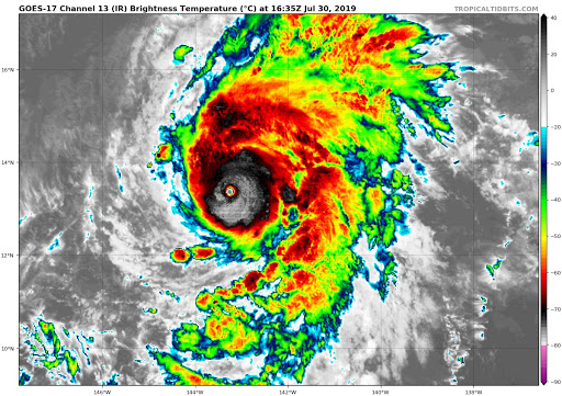
Latest Sattelite imagery shows that Major Hurricane Erick maybe undergoing an Eyewall Replacement Cycle as the eye has clouded up in the last couple of hours. But latest model guidance shows that Erick may restrengthen a bit more tonight as soon as the (ERC) completes. Sattelite Estimates from the SATCON, ADT, and CIMSS Shows that even with the ERC about to occur, the initial intensity has been kept at 120kts (140 mph). The Intensity guidance forecast is on par that winds will be peaking intensity by tonight with Max winds 155 mph making Earick a very strong dangerous category 4 Hurricane. The Hurricane is located about 900 miles ESE from the Big Island of Hawaii and the Forecast track has been adjusted a tad bit south than the previous one allowing the storm to pass safely south of Hawaii. The Hurricane will undergo degeneration starting tomorrow morning. The weakening trend could be so significant that in 24 hours the system could be down to a low-end tropical storm, This is due to increasing wind-shear of 50 to 75 kts by Wednesday night allowing the system to fully get disrupted. I’ll have more details on the live stream on Hurricane Flossie this evening.
Erick has suddenly rapidly intensifiednow to a major hurricane which defies all forecasting models previously. Right now Eric has slowed right around 12 miles an hour as it moves W. Winds have increased to 115 miles an hour making Erick a category 3 hurricane. I will have a live update discussion on major hurricane Erick tonight also I will be talking a lot about tropical storm Flossie as it could be impacting Hawaii later on. The eye with Hurricane Erick is very small indicating that rapid intensification is continuing. Most of the model guidence now brings Eric to a category 4 hurricane by this afternoon. once again I will have a live discussion on this at 5 PM PDT. See you then. 🌊🌪💦💧⛈💨
Thanks For Watching! Make sure to like the video! In this video I talk about the upcoming cool down I expect for the middle portion of August, this won’t be super noticeable, but for some in the east it could mean relief from the heat. expect temperatures 4 – 8 degrees below average for a few days in the east between the 12th and the 16th, this is when the heart of the cool air will be centered over the united states.
“For I know the plans I have for you declares the LORD, plans to prosper you and not to harm you, plans to give you a hope and a future.” (Jeremiah 29:11
How is August looking for you in terms of Temperatures and Precipitation for the Monthly August 2019 Weather Forecast in your area? Find out more in the Video.
Thanks For Watching! Like the Video! In this video I talk about my thoughts on the Beginning of August and how I expect the Start of August to be cool, thru the 5th August should be cold, and cold enough to be noticeable, expect the end of July to be quite warm though. July 27th thru 31st should be quite warm to maybe even hot, this will be very brief however, as again august 1st – august 5th will be cold.
Excessive Heat is building further west as the ridge flexes westward by the end of the week, With it, the Heat will be building in across the West coast in response to the Sub-Tropical Ridge established itself across the Desert SW. Excessive Heat Watches have been issued for the Central Valley as temperatures reach 105 to 115 degrees for a period of 2 to 4 days, Overnight lows in the upper 60’s to upper 70’s. The Humidity with Partly cloudy skies will make it feel a bit sticky. Calm Weather will prevail across the Midwest and Northeast through the Weekend. More details in the Video.
Temperatures soared this weekend across a significant portion of the Northeast and mid-Atlantic, leading several places to experience the first official heat wave of the year. The combination of high temperatures, which climbed into the triple digits in some locations, and high humidity led to AccuWeather RealFeel® temperatures as high as 110 degrees Fahrenheit.
The extreme heat left vulnerable populations at risk when outdoors for extended period. Four heat-related deaths have been reported throughout the region in recent days, and more than 100 residents were forced to evacuate a senior center in New Jersey after air conditioning failed.
At the tail-end of the brutal heat wave on Sunday night, areas of the Brooklyn borough of New York City lost power with more than 30,000 Con Edison power customers reportedly in the dark. As crews worked into Monday morning to restore power, New York City Mayor Bill de Blasio held a news conference about the situation with the city’s electric grid.
De Blasio called for an investigation of the power outages on Sunday, expressing his criticism of the power company after the recent outages. At the time of the press conference on Monday morning, about 19,000 customers remained without power in the city with about 13,000 of them in Brooklyn.
“I am extremely disappointed with Con Ed. They’ve been giving us consistently inconsistent information over these last days,” the mayor said. “This was a situation we all saw coming and I don’t have any good answers yet as to why this happened and why it was not prevented.”
People enjoy the day playing with water as the Empire State Building is seen from Williamsburg on Saturday, July 20, 2019 in Brooklyn, NY. Temperatures in the high 90s are forecast for Saturday and Sunday with a heat index well over 100. (AP Photo/Eduardo Munoz Alvarez)
The utility company has not publicly disclosed the cause behind the outage, but de Blasio said that the company decided to turn off power to thousands of customers so that it could make repairs and prevent a bigger outage. The decision was made as it was getting dark, creating safety and security issues. The city immediately deployed first responders to address this issue. More than 200 additional officers were deployed by the New York Police Department (NYPD).
“I want to commend the NYPD and also the residents of the neighborhood for the way they handled things. As of this moment, the information we have in these affected neighborhoods in Brooklyn, there were no arrests, no summonses, no reports of any problems at all,” the mayor said on Monday.
De Blasio said the company has not provided a “clear answer” for the event and said that the private company is “not accountable to the public in a way a public agency would be.”
“It’s very clear we have to question whether Con Ed as it’s structured now can do the job going forward or whether we need to go to an entirely different approach,” de Blasio said. “I’m calling for full investigation. And further that we examine whether we need a new entity to handle this situation going forward. Because at this point, I do not have faith in Con Edison.”
A little over a week ago, Con Edison customers experienced a power outage in Brooklyn with no clear explanation. De Blasio said they know there was a malfunctioning piece of equipment, but “no answer as to why, no answer as to how they’re going to make sure it doesn’t happen again.”
“This one, too, we’ve got no answer as to why this happened. Given that they knew they were in the middle of the heat emergency and had every opportunity to prepare,” de Blasio said. “I don’t know if it’s related, because we don’t have any clear answers.”
Meanwhile, New York Gov. Andrew Cuomo tweeted that he deployed200 state troopers, 100 generators and 50 light towers to assist with the power outage, as well as personnel and command vehicles from the state Office of Emergency management.
“We have been through this situation with Con Ed time and again, and they should have been better prepared — period,” Cuomo said in a statement. “This was not a natural disaster; there is no excuse for what has happened in Brooklyn.”
Many residents took to social media to express their outrage and frustration about the power outage in Brooklyn.
“It’s still hot and people have a right to be frustrated. We’re pushing Con Ed to get power back as fast as possible,” De Blasio tweeted on Sunday night.
Before the weekend began, New York City declared a heat emergency, as well as a Code Red Extreme Heat Alert.
The sun rises over New York City and next to the Empire State Building while people watch the dawn from Pier A on Saturday, July 20, 2019 in Hoboken, N.J. (AP Photo/Eduardo Munoz Alvarez)
“We are completely focused on getting customers back in service, and we regret the distress they are under,” Con Edison said in a statement. “The actions we took were necessary to prevent longer outages to the impacted customers that would have occurred as a result of additional equipment damage.”
While only a few record temperatures were broken or tied in New York City, the heat remained oppressive and many locations fell just a few degrees short of record-breaking. In downtown New York City, temperatures reached 95 F on Saturday and Sunday, according to AccuWeather Meteorologist Isaac Longley.
“Another big concern with this particular heat wave was the fact that low temperatures at night still remained very warm, especially in New York City where lows only managed to drop into the lower 80s. Due to the warm low temperatures, there was little relief from the heat at night,” Longley said.
Cities were among the hottest locations during the heat wave, largely due to heat island effect, where an urban area is significantly warmer than its surrounding rural areas due to human activities.
“Many cities in the Northeast and mid-Atlantic saw low temperatures in the upper 70s to lower 80s at night, which was caused by the heat island effect. Concrete and pavement prevent heat from being lost at night,” Longley said.
Boston, New York City, Philadelphia, Washington, D.C., and Baltimore were among the cities that experienced near-record warm low temperatures.
“Since there was not much of a cooldown at night in these cities, people without AC may have been at risk for heat-related illnesses due to a lack of a break from the heat,” Longley said.
On Sunday, several locations across the mid-Atlantic reached the 100-degree mark, with several more locations falling a degree short. The AccuWeather RealFeel® Temperature at the nearby airport in Nashua, New Hampshire, reached the century mark for the third consecutive day on Sunday.
Widespread triple-digit RealFeel temperatures created dangerous conditions for residents and visitors across the mid-Atlantic, including at all of the major cities along the I-95 corridor, before noon EDT on Sunday.
Farther north, record temperatures were also broken. The “low” temperature in Boston on Sunday morning sat at 83 F. For comparison, the average high for the day is 82 F.
Bradley International Airport in Windsor Locks, Connecticut, reached 100 by 2 p.m. EDT on Sunday. This ended up being the high temperature for the day, falling short of breaking the record high of 101 F for July 21 set back in 1991.
In New Jersey, Atlantic City hit 100 F on Sunday, breaking a record from 1981 of 99 F.
Many records came close to beating the record high temperatures on Sunday, but ended up tying previous records instead. Bridgeport, Connecticut, tied a record high of 98 F, last set in 1991. Also, John F. Kennedy International Airport in New York hit 99 F, tying a record from 1991.
Following days of extreme heat, a break may be in sight. A cold front is slowly making its way through the Northeast on Monday, bringing a cooldown that will soon bring relief to many.
“However, we will still have to deal with strong to severe thunderstorms [Monday] afternoon, mainly along the I-95 corridor from New York City down toward Richmond, Virginia. The main concerns with these storms will be heavy downpours bringing the threat for flash flooding along with damaging wind gusts,” Longley said.
“Then the fourth angel poured out his bowl on the sun, and it was given power to scorch the people with fire. 9And the people were scorched by intense heat, and they cursed the name of God, who had authority over these plagues; yet they did not repent and give Him glory.” Revelation 16:9
This is not the fulfillment, this is a grace moment, a taste of what is coming, a chance to repent and turn to GOD!
A Heat Wave Is Hitting Much of the U.S. This Week. Here’s How to Stay Safe
Click the link on the Title to view the video on how to stay safe.
Up to 195 million Americans are set to swelter through a “dangerous and widespread” heat wave that will bake two thirds of the continental United States this weekend. Temperatures are expected to hit 100 degrees and even higher in many parts of the Midwest and the East Coast.
This “major heat wave” follows the hottest June on record worldwide, with the global average temperature 1.7 degrees Fahrenheit above the normal for the month. Some have predicted this month could become the hottest July on record as well.
Up to 195 million Americans are set to swelter through a “dangerous and widespread” heat wave that will bake two thirds of the continental United States this weekend. | National Weather Service
“July is the warmest month of the year globally,” Michael Mann, a climate scientist at Penn State, tweeted on Monday. “If this July turns out to be the warmest July (it has a good shot at it), it will be the warmest month we have measured on Earth!”
Michael E. Mann
✔@MichaelEMann
This is significant. But stay tuned for July numbers. July is the warmest month of the year globally. If this July turns out to be the warmest July (it has a good shot at it), it will be the warmest month we have measured on Earth!#RecordWarmth#ClimateChange#NotSubtlehttps://twitter.com
How’s the Month of August looking in terms of Temperatures and Precipitation? Find Out in the Video If your a new viewer and you love my weather content, Please Subscribe to my channel to get daily forecasts on a daily basis and also make sure to like the video, comment and ring the bell icon, Thanks for Support, it keeps me moving. Link listed below www.youtube.com/c/DavidSchlotthauer?sub_confirmation=1
Many cities across the Midwest, Upper Midwest, Northeast are expected to have near record highs with Heat indexes around 105 to 115 degrees with isolated locations near 120 degrees. Make sure your pets are indoors as they could get heat exhaustion as well as kinds. It’s highly recommended that you don’t do any outdoor work past 9 am local time. Overnight lows will range in the Mid 70’s to Lower 80’s in many areas. Make sure your Hydrated during this heatwave. More details in the Video Signs of Heat-related Illnesses: * Cool, moist skin with goosebumps when in the heat * Heavy sweating * Faintness * Dizziness * Fatigue * Weak, rapid pulse * Low blood pressure upon standing * Muscle cramps * Nausea * Headache
Some of the Computer Models are hinting at a Monsoon weather pattern setting up across the Dessart SW including Arizona, Utah, New Mexico, Nevada, and Eastern California. The ridge of high pressure will begin building into the region over the weekend and really establish itself on Tuesday through Saturday Next week from 7/23 to 7/27. While Temperatures look to still range around 100 to 110 degrees, Dewpoints will be on the increase into the upper 50’s to Mid 60’s indicating that a monsoon outbreak including Strong thunderstorms, Small hail, Haboobs, Flash flooding rains and more. I’ll have the full details in the video. IF YOUR A NEW VIEWER and you love my weather content, Please Subscribe to my channel to get daily forecasts on a daily basis and also make sure to like the video, comment and ring the bell icon, Thanks for Support, it keeps me moving. Link listed below www.youtube.com/c/DavidSchlotthauer?sub_confirmation=1
Extreme Heat to Affect Most of the US for the Coming Week, as well as Severe Thunderstorms for the Plains. …Extreme Heat… Very warm temperatures will be spreading across much of the United States for much of July. There shouldn’t be any major droughts because of rain mixing in. This area of warm temps could be stretching from the west to east coast. Temperatures from 15-25 degrees above average is possible, where the warmest temps could be felt near Phoenix, Arizona, and Baltimore, Maryland. Some locations that could see very warm temps. This will last into the mid-week of the coming week, where 1-2 degree above average temps will still be in place.
Temperatures are likely to reach dangerous daytime high levels as we move on through the week across the Midwest and Desert SW. If you plan on going outdoors or doing work outside. Take advantage of the morning hours before 9 am or 10 am Your local time, Excessive Heat Watches and Warnings are in effect for many areas. But how hot could those numbers get, Find out more in the video? IF YOUR A NEW VIEWER and you love my weather content, Please Subscribe to my channel to get daily forecasts on a daily basis and Also make sure to like the video, comment and ring the bell icon, Thanks for Support, it keeps me moving. Link listed below www.youtube.com/c/DavidSchlotthauer?sub_confirmation=1
Join KATC ABC 3 in Lafayette Louisiana with Live, up to date, continuous coverage or Tropical Storm Barry as it moves inland. The Latest news on Power Outages, Rain, Wind, and Flooding
We are Back Tracking Tropical Storm Barry Live from Louisiana with Heavy Rain, Strong Winds and Flooding. We’ll have live updates as they come into the weather office. Tropical Storm Barry Discussion Number 14 NWS National Hurricane Center Miami FL AL022019 400 PM CDT Sat Jul 13 2019 Surface observations and WSR-88D Doppler radar data indicate that the center of Barry moved inland across Marsh Island and Intracoastal City, Louisiana around 16-18Z. Since then, the system has moved farther inland and weakening has started. The initial intensity is reduced to 55 kt based on recent observations from Eugene Island and Cypremort Point. The initial motion is now 330/6. Barry should continue north-northwestward and northward through Louisiana for the next 30-36 h as the cyclone moves through a weakness in the mid-level ridge to the north. After that, the cyclone or its remnants should encounter the westerlies and turn north-northeastward before they dissipate. The new NHC forecast track has changed little from the previous advisory and lies near the various consensus models. Barry should continue to weaken as it moves farther inland, and it is currently forecast to weaken below tropical-storm strength in about 24 h. Subsequently, the cyclone should degenerate to a remnant low between 48-72 h and dissipate between 72-96 h. It should be noted that by Sunday morning the strongest winds will likely be occurring well away from the center over the Louisiana coast and the coastal waters. Barry made landfall as a hurricane. However, due to the poor center definition, the exact times and locations will be determined in post-analysis.
Tropical Storm Barry Discussion Number 10 NWS National Hurricane Center Miami FL AL022019 400 PM CDT Fri Jul 12 2019 Although the storm continues to look disorganized in satellite imagery, surface observations and data from an Air Force Reserve Hurricane Hunter aircraft indicate that the central pressure has fallen to 993 mb with the maximum winds still near 55 kt. A prominent cloud swirl has rotated more than halfway around the eastern and northern side of the mean center since 17Z, and there were several reports of strong winds in association with this feature. Strong convection persists to the south of the center, but to this point northerly shear has prevented the convection from becoming better organized. The initial motion is now an erratic 300/5. Barry should turn northwestward during the next several hours as it approaches a weakness in the mid-level ridge over the Mississippi Valley, and this motion should bring the center across the central coast of Louisiana between 12-24 h. After landfall, the system should move northward through a break in the ridge until the 72 h point, after which it should recurve northeastward into the westerlies. The guidance envelope has shifted slightly westward since the last advisory, but the shift is not large enough to require significant changes to the forecast track. Thus, the new track forecast again has only minor tweaks from the previous one, and it lies just east of the various consensus models. Barry continues to strengthen despite the asymmetric convective structure, the shear, and the presence of mid- to upper-level dry air over the northern semicircle. The intensity guidance forecasts continued intensification until landfall, and so will the NHC forecast. While not explicitly shown in the forecast, Barry is expected to become a hurricane near the time it makes landfall between the 12 and 24 h forecasts points. After landfall, the cyclone should steadily weaken, with decay to a remnant low expected to occur in about 72 h and dissipation after 96 h.
Forecasters say Tropical Storm Barry continues to gain strength and will likely strike the Gulf Coast as a hurricane. It’s on track to hit Louisiana with dangerous flooding. David Begnaud reports.
BREAKING NEWS FROM TEXAS NEWS STUDIO BREAKING FLASH ALERTS AND SPECIAL REPORTS LIVE BREAKING NEWS AND INTERNATIONAL NEWS COVERAGE BREAKING MILITARY UPDATES
SUMMARY…Storms capable of severe wind gusts as well as large hail continue within WW 498. Linear storm mode will favor severe wind gusts as the primary threat. A downstream WW or WW extensions will likely be needed in the next 1-2 hours. DISCUSSION…Thunderstorms in WW 498 have clustered into several linear segments. Given the extreme buoyancy out ahead of this activity — 3500-4000 J/kg MLCAPE — storms will continue to propagate eastward and pose a threat for severe wind gusts. Though deep-layer shear is modest (around 30-35 kts) and storm mode has become more linear, steep level lapse rates will support large hail in the stronger cores. Stronger storms have also developed within southern Manitoba, some of which may move into portions of northern Minnesota. A downstream WW or WW extensions will need to be considered within the next 1-2 hours as the activity is expected to maintain its intensity into the early evening. IF YOUR A NEW VIEWER and you love my weather content, Please Subscribe to my channel to get daily forecasts on a daily basis and also make sure to like the video, comment and ring the bell icon, Thanks for Support, it keeps me moving. Link listed below https://www.youtube.com/channel/UC5C6… WeatherDrone101 https://www.youtube.com/channel/UCEqH…
Anomalous trough of low pressure continues to impact much of the north west and the west coast bringing the continued below average temperatures. Another cool down is on the way for much of the desert southwest stretching northward across the west and the Pacific Northwest. Temperatures could be 10 to 20° below average for this time of year. Continued showers and thunderstorms will impact the Northeast in the southeast including the Midwest for this upcoming week with warm, humid conditions. How’s the rest of the United States looking find out more by watching the video. Check out my brand new Davis Vantage Vue Pro 2 Plus weather station data live……. https://www.wunderground.com/dashboar…\ If Your an New Viewer and you Love my Content, Make sure to Subscribe, Like, and Comment, also Share my weather content with your family as i’m trying to warn as many as i can. Subscribe Here: https://www.youtube.com/channel/UC5C6… Follow me on Social Media Via……. Facebook: https://www.facebook.com/david.schlot… Twitter: https://twitter.com/Weathermandavid Instagram: https://www.instagram.com/davidschlot… Discord: https://discord.gg/cxwCRT
Barbara is a large and powerful hurricane. The latest ASCAT scatterometer data confirms that tropical-storm-force winds extend up to 160 n mi from the center, while the hurricane-force winds extend up to 30 n mi from the center. A very impressive outflow channel exists over nearly a 20 degree swath of ocean to the north of the cyclone. There are at least two mesocyclones evident in the well-defined eye, and cloud tops are colder than -70 degrees C in most of the eyewall. A compromise between the subjective satellite intensity estimates from TAFB and SAB and the objective estimates of CIMSS ADT and SATCON yield an initial intensity of 120 kt for this advisory. Barbara continues to move toward the west-northwest or 290 degrees at 12 kt, to the south of a mid-level ridge extending from the west coast of the United States westward across the eastern Pacific. Barbara will turn northwestward in 36 to 48 hours as it reaches the southwestern periphery of the ridge. Thereafter, once the cyclone weakens to a shallow system, it should turn back westward steered by the low-level flow as per the majority of the track guidance. There is still a small window of opportunity today and this evening for additional strengthening of Barbara, while it remains over SSTs greater than 28 deg C and in a low shear environment. The SSTs ahead of Barbara start to decline Wednesday morning due to the forecast track taking the hurricane over progressively cooler waters of about 26.5 deg C in 24 hours, and near 25 deg C in 72 hours. In addition, the cyclone will be approaching a more stable airmass and moving into increasing southwesterly vertical shear within a few days. All of these conditions suggest that Barbara should begin a slow weakening trend on Wednesday, with the weakening accelerating after 48 hours. By the time Barbara reaches the Central Pacific, it is likely to be a tropical storm or even a remnant low. If Your an New Viewer and you Love my Content, Make sure to Subscribe, Like, and Comment, also Share my weather content with your family as i’m trying to warn as many as i can. Subscribe Here: https://www.youtube.com/channel/UC5C6…


Hurricane Erick expected to weaken to a tropical storm before reaching the Hawaiian Islands
Published on Jul 30, 2019