 spacer
This amazing mural has stood for the honor and glory of the United States of America for many years. It is a major bastion of American Freedom and a treasure to all true Patriots. I am certain that in the minds of the Ruling Elite this monument cannot be allowed to continue to stand so majestically proclaiming freedom.
I was restoring some photos to an old post when I came across this story. I was struck with the symbolism not only of the monument itself, but with the location and the symbolism of the cities and the county involved. Most importantly I was interested in the fact that the location is in CORONA and the timeframe of this entire saga seemed uncanny to me.
The Monument celebrates the birth of FREEDOM in 1776 and the Bicentennial Celebration of that even in 1976. Now we see that the Completion date for the restoration of the monument is slated for July 4, 2023.
We know that the ruling elite want to remove all monuments to our countries past. They want to destroy all evidence of Patriotism in every nation. This particular monument celebrates the winning of our Freedom and the establishment of our nation. I just can’t see that they ever intend to allow it to be restored.
The American people have made their voices heard. They have put their money where there mouth is as well and have raised and continue to raise funds to help cover the cost of it’s restoration. It has been a long hard battle, but the people have stood. This monument holds a dear place in the hearts of not only the people who drive by it regularly on Highway 91, but really to people all across the nation to whom FREEDOM and the United States of America are to be cherished, honored and maintained!!
If you have not seen the earlier posts in this series, Check them out here:
Its a DAM Shame – Part 1 – ALERT! KEEP WATCH! Your Neighborhood is in TROUBLE
It’s a DAM Shame – Part 2 – SOLD DOWN THE RIVER BY OUR GOVERNMENT!
It’s a DAM Shame – Part 3 – Dam Safety
It’s a DAM Shame – Part 4 – OUR DAMS NATIONWIDE
It’s a DAM Shame – Part 5 – 2020 NO IMPROVEMENT
It’s a DAM Shame 2
spacer
Just for fun see how many times you can spot double 8’s in this post.
spacer
 |
 |
Although the term corona was first used in English in the 1500s, it was borrowed directly from the Latin word for “crown.” Corona is derived from the Ancient Greek κορώνη (korōnè), meaning “garland” or “wreath,” coming from a proto-Indo-European root, sker– or ker-, meaning “to turn” or “to bend.” traditional representations of crowns as radiant headbands, worn as symbols of sovereign power, to liken that power to that of the sun. Ancient gods are frequently represented wearing a crown or corona. Helios the Sun wears a radiant crown and represents power and energy and strength. Circle City: Circles are among the oldest of geometric symbols, and commonly represent unity, wholeness, and infinity. The circle is also used nearly universally to represent the sun and/or the moon, or things associated with those bodies. The astrological symbol of the sun is a circle with a dot in the middle. The same symbol is used to represent gold, which i strongly associated with the sun. Element of Spirit seen as an element equal to or superior to the physical elements of fire, air, water, and earth, is commonly represented by a circle. Circles are also seen as a protective symbol. Circles can also represent containing, keeping what is inside from been released. Orange is the new black because orange represents the warning just before death of the sun. The sun in its decline into darkness which we call night or winter time.This is the Illuminati’s color code: WHITE For each order, balance the aura, because all colors originate from white. Energy, security, stimulation, inspiration, destroys destructive energies, cleanses the aura. Provides protection when applied to others and direct. The Moon rules white. The White governs the third eye, along with indigo and silverINDIGO Meditation, psychic abilities, telepathy, mind reading, communication with spirits, absorbing knowledge telepathically. The Moon is the host to the color indigo. Indigo is the quintessential element / ether / spirit. Indigo governs the third eye, along with the colors silver and white, and the sixth chakra. |
“Orange is the New Black.” In other words. It’s the new color of death. This is why prisoners wear orange just like the victims of Isis, you know the beheadings and decapitations? This is why we find these beheadings in September which means the separation of seven. This is the end of the year which has been decapitated. It’s the same decapitated head of the goddess Kali.
Orange is the new black because orange represents the warning just before death of the sun. The sun in its decline into darkness which we call night or winter time .oranges originated in China The word sinensus comes from the Latin for China or Chinese and refers to the orange tree’s origins. Citrus sinensis is an evergreen tree. So..immortality. The five pointed orange blossom represents Satan – the pentagram. Green can also be used to incite jealousy, greed, suspicion, resentment, illness, disorder, disharmony when applied to others and direct. Mountain peaks, where heaven and earth touch, are places of divine revelation. An ascent to a mountain top is a symbol of initiation. The Mountains are the Place of the gods. Black absorbs and hides and creates confusion and chaos, new beginnings, knowledge of hidden things, is the container of light, one of the most powerful color. Use black for the self-control, time and patience. Black is also a good color to use to bring discord and confusion within the enemy. It can also be used for protection, wrap negative energy, breaking barriers and blocks, reverse and destroy negative thought forms. It ‘s better if applied to others. Black controls the base chakra, the planet Saturn, the earth element and the original religions, it means new beginning. Satanic alchemy, black represents the step into the void of meditation and transformation. |
spacer
Crown of justification or Corona Mortis/Crown of Death
In ancient Egyptian religion, the crown of justification (mʒḥ n mʒ‘ ḫrw[2]) was a wreath or fillet worn by the deceased to represent victory over death in the afterlife. Its symbolism is based on Chapter 19 of the Book of the Dead, in which the wearer is said to be “justified” by a triumph over death just as the god Osiris eventually rose above his enemies. A ritual text was recited as the dead person was crowned.[3]
The crown of justification might be made of laurel, palm, feathers, papyrus, or precious metals. It was syncretized with the solar crown of the sun god Re, and might be made of gold to mimic the properties of the sun.[
Check out my post:
FINAL SOLUTION – CROWN OF DEATH
spacer
spacer
|
|
|
|
|
Chino, California |
Eastvale, California |
Norco, California |
| An arch is a spiritual doorway or poral. Aches are symbolic of the expansiveness of sky. were symbolic of Greco-Roman sky gods Zeus and Jupiter. They are also connected with initiation and ceremonies of renewal in many cultures. Walking through an archway represents the sloughing off of the old and moving into a new phase of life. Of course we see the Rising Sun through the Arch. Symbolic of Sun Worship. Planted fields on rolling hills. Abundance. Note the rows form V, the sign of the Horned God of witchcraft, Pan; or Baphomet, the androgynous (male and female) goat god. | Several things stand out to me on this logo. First of all, the Mountains or High places, the Sunburst rising above them and the word “Pride: in the Center at the bottom of the seal. The red ribbon, signifying blood. Prosperity of course tells us what they worship/money. This is natural since they call the area the Empire. I am not srue what to think of the three-toned snaking river flowing into the red white and blue and stars. Looks like one edge is gold…maybe gold rush plays a role in their “prosperity”? Gold is the color of wealth and power. Satan has a golden aura. Gold is the color of the Sun and the element fire | Horse symbolism in classical myth In classical mythology, horses are often depicted pulling chariots of important deities. Because of their speed and strength, horses were the ideal animals to pull the sun across the sky for Phoebus Apollo, although similar chariot-stories surround Mithras in ancient Rome and Elijah in the Old Testament. Horse a majestic and magical animal a symbol of the Spirit and the desire for freedom |
| A portmanteau word, or portmanteau (/pɔːrtˈmæntoʊ/ ( A portmanteau word is similar to a contraction, but contractions are formed from words that would otherwise appear together in sequence, such as do and not to make don’t, whereas a portmanteau is formed by combining two or more existing words that all relate to a single concept. A portmanteau also differs from a compound, which does not involve the truncation of parts of the stems of the blended words. For instance, starfish is a compound, not a portmanteau, of star and fish, as it includes both words in full. If it were called a “stish” or a “starsh”, it would be a portmanteau. |
spacer
spacer

Prado Dam May Break in Flood, Engineers Warn – Los Angeles Times
Corps officials said the interim plan to raise Prado Dam by 15.5 feet would eventually be tied in with the overall flood-control plan to raise the dam by 30 feet and offset the eventual cost of that project.

BELOW PRADO DAM – The heat wrung sweat from the human body as if it were a sponge, even when people stood still in the shade, but the team of scientists nevertheless pulled on stiff rubber boots and waders.
One of them, Larry Brown, strapped on a metal backpack connected to a pole with a ring at the end – the shocker. He would deliver a jolt to the gently flowing water of the river as he waded through it, enough to stun any fish swimming nearby. They would be scooped into buckets by his companions.
It was busy season for this year’s National Water Quality Assessment for the Santa Ana River, part of a nationwide effort to track the health of the nation’s waterways.
And despite a years-long track record, congressional funding could run dry: There might be only one more season of intensive federally funded sampling for this team of U.S. Geological Survey scientists. If so, they might have to find other funding sources to continue what has become a scientifically valuable, long-running survey of the river.
“I hope I don’t get shocked this time,” said Carmen Burton, a hydrologist who was leading the study.
“Shock therapy,” said biologist Marissa Bauer.
Orange County residents know the Santa Ana River as little more than a concrete or rock-lined channel, good for moving storm water to the ocean but not exactly a magnet for wildlife.
But naturalistic stretches of the river remain. The Santa Ana flows some 96 miles, from the San Bernardino Mountains, where it is held in check by the massive Seven Oaks Dam, to its mouth on the Orange County coast.
Sections of the river above Prado remain in a natural state, and a meandering portion below the dam also appears natural – as long as one doesn’t get too technical about it.
In reality, of course, the river’s banks are home to as many invasive, non-native species as they are to natives. Alien eucalyptus trees stand shoulder to shoulder with giant native cottonwoods. Native willows fight for space with Arundo, or giant reed, a bamboo-like invader that vexes conservationists…
Carp, bluegill, bullhead, bass: all of them temporarily paralyzed so they could be gathered with nets.
Burton hoped they might encounter a Santa Ana sucker, possibly the only native fish species left in this part of the river. But they had no such luck. Every species caught was a non-native.
Only one sucker, in fact, has turned up in seven years of surveys.
On natural parts of the river, especially at higher elevations above Prado dam, healthy numbers of the threatened suckers still exist. It’s unknown whether stretches of the river closer to Orange County still harbor suckers.
That’s one interesting finding that has emerged from the years of study. The reasons for the sucker’s decline are uncertain, but might be connected with habitat loss and competition from more numerous non-native species.
Another odd effect the scientists might be seeing, though so far with only anecdotal evidence to back it up, concerns antibiotics, sewage and parasites.
An estimated 90 percent of the water flowing down the river is highly treated sewage – clear and almost entirely bereft of contamination, but treated sewage nevertheless.
And some pharmaceutical compounds can pass through the treatment process.
Robert Fisher, a USGS biologist who sampled the river in the late 1980s, said he found fish loaded with external parasites. That was when the river was contaminated with significant amounts of dairy waste, with relatively less treated sewage flowing through.
Now a variety of sewage-treatment plants pump their effluent into the river. And external parasites, Fisher said, are rarely found on the fish that are caught.
“One of the ideas was that there are enough antibiotics in the system now that they’re actually killing the external parasites,” Fisher said.
And while that might sound like good news for the fish, many scientists worry about other, potentially harmful effects of such compounds on aquatic life-forms.
The National Water Quality Assessment, with 50 projects throughout the country and two others in California, is meant to track not only water quality, but the health of aquatic ecosystems, said Ken Belitz, a research hydrologist who is also program chief for the Santa Ana River assessment.
Scientists have been sampling the Santa Ana River since 1999. Despite the years of sampling, however, it might be too soon to draw too many sweeping conclusions about the river, he said.
“It hasn’t been that long,” he said.
Still, the extensive alteration of the river by people could yield a wealth of scientific insight.
“The Santa Ana basin provides an example of a highly urbanized watershed,” he said…
spacer
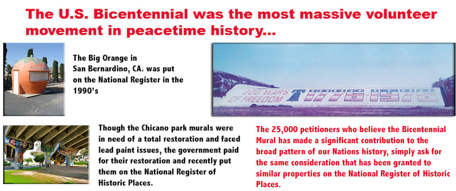
- This October, with no public debate, the Army Corp of Engineers has decided to strip off one of the largest Murals in the United States. The beloved 1776 – 1976 Prado Dam Mural in Corona, CA.
- It’s unimaginable to think that such a decision could be made without a “policy” set in place for a total, vintage restoration of the mural. But to date their only statement has been “”Any plan for follow-on actions regarding repainting of the spillway are undetermined at this time“.
- The Corp has also stated in most vague terms that “They did not want to paint a new mural until the construction on the spillway was complete so that they would not have to protect the Mural area” (which is not a real issue) What is not in this statement was the fact that The Corp will not raise the spillway until 800 to 1,000 acres are purchased on the back side of the Dam. At that point they will need to secure the allotted funds to raise the spillway.
- Here’s the clincher for those of you who think your going to be re-painting the Mural next year. When asked about a time table from the Orange County Water District and Corp, the only comment I received was due to a lack of funds (up words of $300 million) the project has now dragged on for 15 years. That’s right, it could easily take another 15 years!
How To Save The Mural
- Demand the Corp. release a policy Statement of their commitment to a full restoration, before they strip the Mural. Our friends at Congressman Calvert’s office have yet to receive such a policy statement from the Corp. So as time is of the essence it’s time to contact the Corp, local politicians and the press before it’s too late.
- Only when we get the statement, can we petition to repaint the Mural on the freshly striped concrete. With new anti graffiti paints and an organization to protect the mural from any damage can we be able to convince the Corp. and all those concerned that the Mural is ready to be restored.
- Contact the Army Core Of Engineers Greg Fuderer Gregory.A.Fuderer@usace.army.mil,
- Contact Senior Public Affairs Specialist Army Corp of Engineers. 213-479-8698
Please see web site Friends Of The Prado Dam Mural, for more info.
spacer
Sunday, March 22, 2015CHINO HILLS, Calif. (KABC) — The 74-year-old Prado Dam in Chino Hills was originally built for flood control to protect San Bernardino County from mountain runoff, and now a $2.3 billion modernization has reconfigured the dam for multiple uses.
“The number on capacity that we have here for the dam is for flood control, that’s our primary mission. So if we did have a flood threat we’ll make sure that we do have sufficient capacity to handle that flood,” said David Van Dorpe with U.S. Army Corps of Engineers. “Right now there’s not very much water behind our dam. We’re hoping that we do get a little more rain here in the spring before we go into the dry summer months.”
The drought has not produced much runoff to store water, but once the project is complete the dam will be able to store most of the rainfall and runoff.
In the years past, much of it would flow from the Santa Ana River down to the ocean, engineers said.
But the Prado Dam is best known for its patriotic mural, which was painted in 1976. It can be seen on the 91 Freeway traveling through Corona.
Upon closer inspection, the mural is faded, damaged by weather and defaced with graffiti. Dam engineers said the mural will have to be removed.
“When it was originally painted in 1976, they used lead-based paints. We can’t risk getting that lead-based paints either into our environment, or our water supply, or to the ocean so the mural it does have to come down,” Dorpe said.
A public hearing on the mural will be held at Corona High School on April 9. The removal process will begin at the end of April.


spacer
Supporters say the mural could be sealed in a way that would eliminate the environmental risk and preserve the chipped and faded paint.
“It certainly appears to be one of the last highly-visible either artworks or things of any kind associated with the bicentennial nationally, anywhere. And we hope that it will be preserved,” said Daniel Paul, an architectural historian who is lobbying to preserve the mural.
The Mural Conservancy of Los Angeles has filed a complaint to save the mural, and plans to file a temporary restraining order as well. The group Friends of the Prado Dam Mural have collected more than 8,000 signatures to preserve the mural.
The purpose of this group is to rally forces to save the existing Prado Dam mural as a Vintage Restoration. Please contact your public officials to let them know what you want done.
 http://friendsofthepradodammural.com/
Thanks for join us in this fight!
Friends of the Prado Dam Mural
 In May of 2014 there was a Public Notice on the L.A. Army Corps Website, stating they would be wiping out the Prado Dam Mural without determining if Historic properties are present or engaging the public. On August 6th 2014, the Corps Public Affairs specialist stated there are no plans to repaint the spillway. Then on October 15th 2014 the Corps announced they would seek public input on a replacement Mural. It was now clear that the Corps did not recognize the historical significance of the mural. In May of 2014 there was a Public Notice on the L.A. Army Corps Website, stating they would be wiping out the Prado Dam Mural without determining if Historic properties are present or engaging the public. On August 6th 2014, the Corps Public Affairs specialist stated there are no plans to repaint the spillway. Then on October 15th 2014 the Corps announced they would seek public input on a replacement Mural. It was now clear that the Corps did not recognize the historical significance of the mural.
Because of the outpouring from a Petition drive by the Public and their elected officials calling for the mural to be preserved, the L.A. Army Corps Of Engineers held a Public meeting at the Corona Preforming Arts Theater on April 9th 2015. Over 300 mural supporters attended and unanimously supported the History and significance of the Mural. The supporters were told by the Committee that there passion was heard loud and clear. |
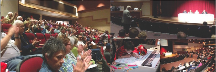 Mural Supporters at Corona Performing Arts Center
|
| It was an amazing night! 50 supporters got up to speak, even city council members voiced their support for the mural. One of the supporters was present during the 1938 flood of the former City of Prado. Then a young man stood up and said he would be 83 for the Countries Tricentennial and he wanted the Bicentennial Mural preserved, the applause was inspiring! |
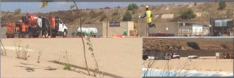 Top of the Prado Dam Spillway |
To the dismay of the public, on June 8th 2015, the Army Corps placed equipment on top of the Prado Dam spillway, to destroy the Bicentennial Mural. |
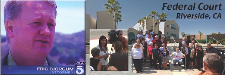 Supporters Go to Federal Court For an Injunction |
Just hours before the Mural was to be destroyed, Attorney Eric Bjorgum, representing the Mural Conservancy of LA and Mural artist Ron Kammeyer went to Federal court and got a temporary injunction, halting the murals’ destruction. On August 25th 2015 Federal Judge Jesus Bernal handed down the court’s decision that plaintiffs have met the standard for entry of a preliminary injunction stopping further work on the Bicentennial Freedom Mural pending the final resolution of the case. Since the Judges decision, the Army Corps has agreed to assess the eligibility of the Mural for the National Record Of Historic Places, in consultation with the California State Historic Preservation Office. Both parties have now agreed to put on hold their Federal case until this important, Section 106, review of the Mural is completed. Over the next few months, consulting parties and the Public will weigh in on the Historic significance of the Mural. |
Donate TODAY For The Mural’s Spring 2023 Repaint!!
 |
|
 |

Technical Tour of the Prado Dam
ORANGE COUNTY BRANCH NEWSLETTER
ENVIRONMENTAL AND WATER RESOURCES INSTITUTE
 By Remi Candaele M.S., P.E.
JUNE 2018

John Sweeten (USACE) discussing the improvements of Prado Dam
John Sweeten welcomed the attendees and shared the history of the dam: how it was constructed in 1941, and serves as the primary flood control facility that protects much of the Santa Ana Region in Orange County. Because of the growing urbanization, sediment accumulation, and the necessity by OCWD to store additional water in response to the drought, the embankment has recently been raised by 28.4 feet to 594.4 feet NGVD29. Upon acquiring facilities that are within the inundation area, the spillway will also be raised.

Prado Dam looking downstream

The ASCE OC EWRI Committee would like to thank John Sweeten for the insightful technical. Additional acknowledgments to the EWRI Committee (Roger Chung, Jennifer Marks, Ben Smith) for welcoming the attendees.
Feds Say Famed Corona Mural Does Not Qualify as National Treasure


A 42-year-old patriotic mural in Corona’s Prado Dam does not meet the necessary criteria for preservation as a federally protected landmark, according to the U.S. Army Corps of Engineers.
The agency on Thursday released a final determination regarding the status of the Bicentennial Mural, advising the California Office of Historic Preservation that it had concluded its study of the issue and could not find justification for retaining what’s left of the artwork under standards established by the National Historic Preservation Act.
The Corps last year issued a preliminary finding that the mural did not qualify for inclusion on the National Register of Historic Places. Additional evaluation since that time has not changed the Corps’ original determination, agency officials said.
They noted that more than 200 letters and a petition containing 30,000 signatures had been received, urging the government to find exceptions that would permit the beloved mural to be maintained. However, the Corps could not identify any means by which to meet terms of eligibility, officials said.
The first criterion for preservation would be that the edifice be at least 50 years old, and the mural falls short of that by nearly a decade, according to the Corps.
“National register eligibility demands evidence of exceptional importance for properties less than 50 years of age,” the Corps’ letter to the California Office of Historic Preservation states. “The difficulty with establishing the Bicentennial as its own significant event is that its `significance’ is derived from the significance of the event it is commemorating — the founding of the United States.”
“The Corps has … found that the Bicentennial did not have any verifiable effect on cultural or civic institutions, legislative development, social ordering, or on any other thematic subject,” the letter continues. “Commemorative properties typically honor a person, place, or event in history and achieve memorial status as the years pass. However important such persons or milestones may be, historic monuments cannot be listed in the National Register of Historic Places for their a association with the individuals or events for which they were created.”
“Because it is a commemorative property, the mural cannot be eligible unless it derives significance from aspects other than from the Bicentennial it proclaims,” according to the Corps.
The future of the mural is in doubt. The Corps still has plans to dismantle it, barring any further legal challenges.
The Riverside County Board of Supervisors, along with city councils in Corona, Eastvale and Norco, have passed resolutions urging restoration and preservation of the display.
In 2015, the Mural Conservancy of Los Angeles federally sued the Corps to halt moves toward removing the mural. A U.S. District Court judge in Riverside signed a restraining order barring any work at the site until all options for the mural’s future were explored.
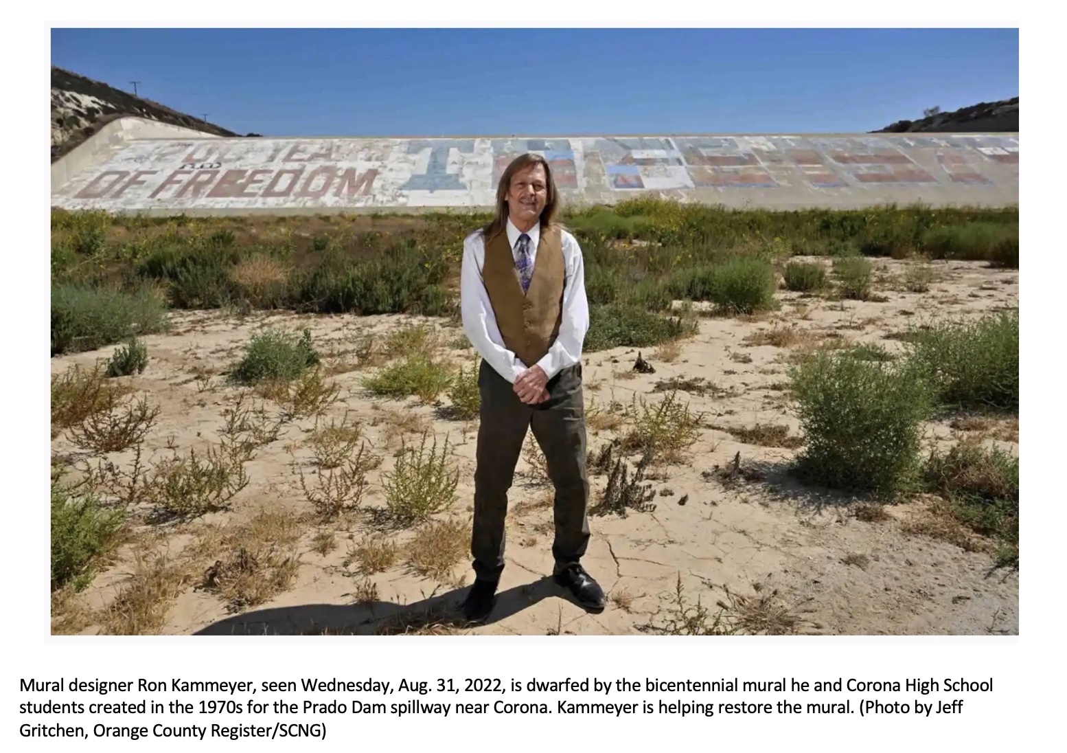
The Corps, which controls Prado Dam, issued findings in 2014 that the best way to proceed was to remove the dilapidated mural, which is 106 feet tall and stretches 2,280 feet across. The deconstruction plan ran into stiff opposition from area activists, led by Ron Kammeyer, who helped create the mural, which the Corps argues poses a hazard due to lead paint decay in the spillway.
The mural, situated inside the flood control channel for the Santa Ana River, was painted in May 1976 to celebrate America’s 200th birthday. More than 30 Corona High School students spent several weekends voluntarily working on the project.
When completed, the mural read “200 Years of Freedom,” with a space depicting the Liberty Bell, followed by “1776-1976” painted in red, white and blue.
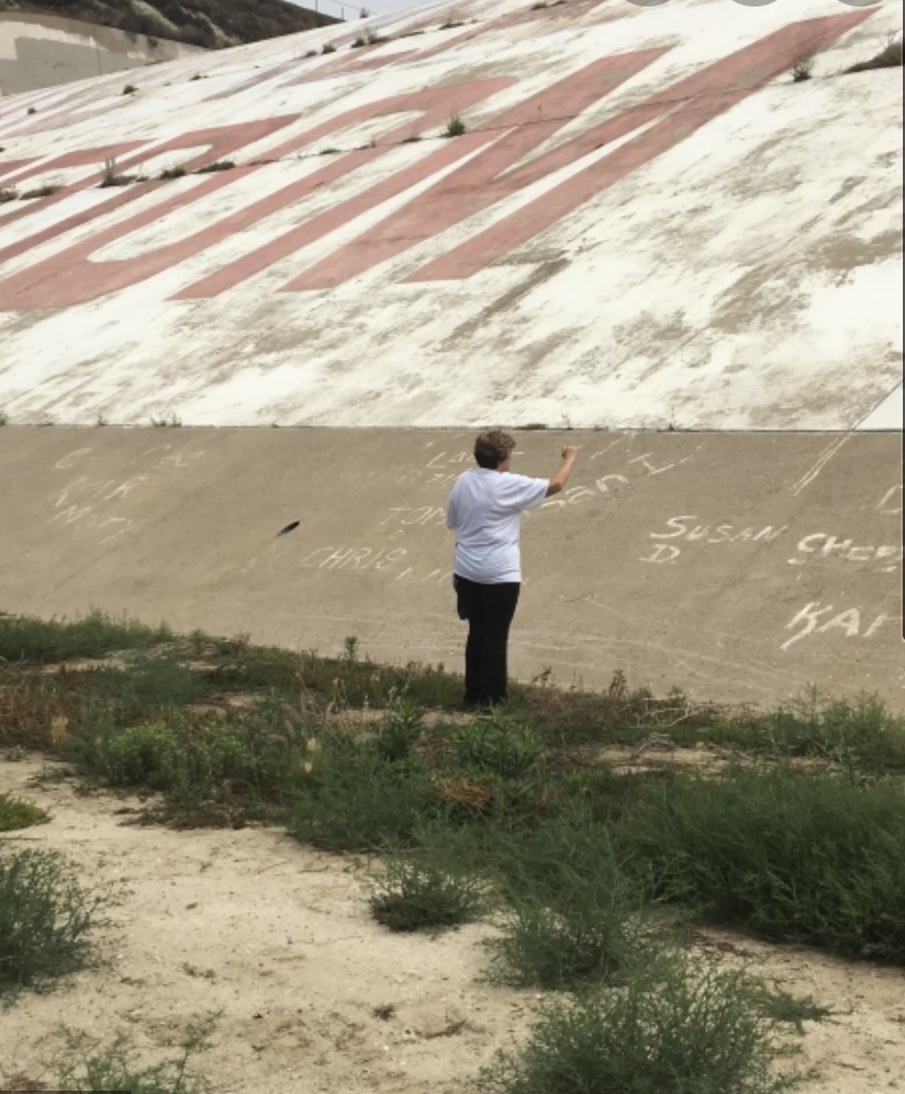
Over the years, the display has suffered weather-related decay and graffiti vandalism, blotting out some of the original scheme, though it’s still visible from portions of the Corona (71) Expressway and the Riverside (91) Freeway.
More information is available at friendsofthepradodammural.com .
spacer
Save The Largest Patriotic Mural In America

![]()
| Your signatures did it: It took time, but we never gave up and now we’re now green lit to have the Mural repainted this Spring. Our next step is to raise the funds. You can go to our donate link below, under updates. (pradodammural.com)
At six times the size of Mount Rushmore, the Bicentennial Mural at the Prado Dam has established itself as a Gateway to the Inland Empire. It was painted in 1976 by 20 girls, and 10 boys from Corona High for the 200th anniversary of the Declaration of Independence. it’s message is inspiring, not only does it “EXPRESS THE IDEALS OF OUR NATION”, it’s also been accepted as public art. But unlike other monuments of it’s kind, it has no ones face on it, so it directly impacts the observer. This beloved Mural, like the Bicentennial, brings people together with the spirit of volunteerism, friendship, and working together. Like so many have told us, “I know I’m home when I see it”. The mural’s lead paint removal is slated for early fall by the U.S. Army Corps of Engineers. It will then be restored to the original design by the Spring of 2023 using funds raised by the Bicentennial Freedom Mural Conservancy (a 501 (c) 3, the Friends of the Prado Dam Mural and contributions from local businesses. Let us share it with the world again, by donating to repaint it for the Fall of 2023. Thank you’s go out to Congressman Ken Calvert, Riverside County Supervisor Karen Spiegel, the Army Corps Engineers, and the Los Angeles Mural Conservancy, for all their hard work to bring this beloved mural back to it’s former glory! The battle is not over until the project is complete: To sign the petition, click the following link to the webpage: |
spacer

Prado, located on the Santa Ana River in Corona, is an earth-filled dam which was built in 1941. The dam is normally dry, the Corps reports, and has never experienced a large enough storm to breach the spillway.
However, the latest examination determined that a significant flooding could indeed breach the spillway, which would put the approximately 1.4 million people who live in 29 cities downstream of the dam in possible danger, along with $61 billion worth of property.
Engineers are specifically concerned about how well the concrete portion of the spillway would hold up in flood event, the Corps told The Los Angeles Times.
Cities from Newport Beach to Anaheim, including the Disneyland resort, would be vulnerable, the Times reports.
According to the Corps, a modification project is expected to begin in 2021 to “reduce the risks associated with the spillway.”
Amid heavy rain in February 2017, nearly 200,000 people who live downstream of the Oroville Dam in Northern California were forced to evacuate after authorities feared that its spillway might fail.
In December of 1963, the Baldwin Hills Dam failed, sending 292 million gallons of water gushing into several West Los Angeles neighborhoods. Five people were killed, 65 homes were destroyed and another 210 homes were damaged. That dam is now a park.
spacer
Prado Dam Failure Could Flood Dozens Of OC Communities
The 78-year-old earthen dam is all that stands between 1.4 million people and floodwaters during the next huge series of Pacific storms.


ORANGE COUNTY, CA — Federal engineers have raised an alarm that a “significant flood event,” such as a series of strong Pacific storms, could breach the spillway of the aging Prado Dam, in Orange County. Such an event has the potential to drown out dozens of downstream communities, from Anaheim’s Disneyland to Newport Beach, the Army Corps of Engineers Los Angeles District reported…
Given concerns that Prado Dam poses a flood threat to much of Orange County, the agency is collaborating with Los Angeles, Orange and Riverside counties and several dozen municipalities to develop emergency plans to implement before repairs to the dams are completed.
“A troubling theme is emerging as the Corps reviews its portfolio of large flood control systems that were built a long time ago and are now showing signs of severe stress,” said Daniel Swain, a UCLA climate scientist told the LA Times. “Federal engineers are finding that these systems are not as resilient as they thought they were and that the frequency of what were regarded as once-in-a-lifetime storms is increasing significantly.”spacer

spacer
Prado Dam Mural Restoration Promise by Original Artist Ron Kammeyer
![]()
2.19K subscribers
spacer
![]()
Forecast Informed Reservoir Operations
FIRO is a reservoir-operations strategy that better informs decisions to retain or release water by integrating additional flexibility in operation policies and rules with enhanced monitoring and improved weather and water forecasts (American Meteorological Society; 2020).
FIRO is being developed and tested as a collaborative effort in the Russian River Basin (Lake Mendocino), the Santa Ana River Basin (Prado Dam), and the Yuba-Feather River Basins that engages experts and stakeholders in civil engineering, hydrology, meteorology, biology, economics and climate from several federal, state and local, universities and others. There is significant interest and support for developing FIRO at other appropriate locations in the Western U.S. and elsewhere.
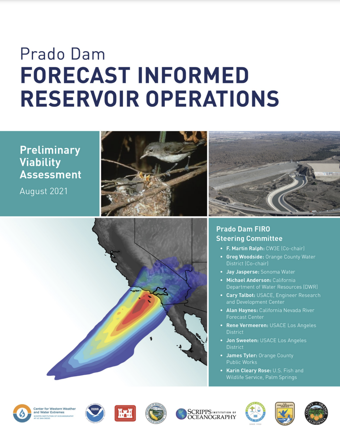
To increase the efficiency of stormwater capture at Prado Dam, CW3E is collaborating with the Orange County Water District (OCWD) and U.S. Army Corps of Engineers (USACE), Los Angeles District to see if the lessons learned implementing FIRO at Lake Mendocino can be transferred and applied to the Santa Ana River Watershed. Prado Dam is located in Riverside County near the City of Corona at the upper end of the Lower Santa Ana River Canyon, about 30.5 miles (49 kilometers) upstream of the Pacific Ocean (see figure 1). This natural constriction controls 2,255 square miles (5,840 square kilometers) of the 2,450 square mile (6345 square kilometer) Santa Ana River watershed.

Figure 1. Map of the Santa Ana River Watershed.
Prado Dam, constructed in April 1941 by the USACE, Los Angeles District, is the downstream element of the Santa Ana River flood control system and provides flood control and water conservation storage for Orange County, California. Since its construction, OCWD and the USACE have worked together to maximize the capture of stormwater behind the dam, an important source of water supply to the Orange County Groundwater Basin. Currently, OCWD is allowed to temporarily conserve up to 10,000 acre-feet (AF) of water behind the dam during flood season (Oct-Feb.) and 20,000 acre-feet of water in the non-flood season (March-Sept) (figure 2). FIRO is being studied to assess the feasibility of allowing 20,000 AF of water to be conserved behind the dam year-round.
The purpose of Prado Dam is to collect runoff from uncontrolled drainage areas upstream along with releases from other storage facilities. Generally, when the water surface elevation in the reservoir pool is below the top of the buffer pool elevation (498.0 feet during the flood season, 505.0 feet during the non-flood season), water conservation releases are made to help fill the groundwater recharge facilities. When the water level in the reservoir exceeds the buffer pool, flood control releases are made in an effort to drain the reservoir back to the top of the buffer pool as quickly and safely as possible. Recently, the existing dam and reservoir have been enlarged and the release capacity of the outlet has been increased to provide additional capacity for storage of flood waters and sediments and to take advantage of the increased downstream channel capacity. Once the ongoing construction of the Corps of Engineers’ Santa Ana River project (Reach 9 Project) is completed, the new outlet works will allow for increased flood control releases and greatly improve the level of flood protection to the communities of Orange County in the Santa Ana River flood plain.

Figure 2. Current water conservation pool program at Prado Dam. Source: OCWD
Over the past 25 years, OCWD has captured and recharged an average of 55,000 AF of stormwater per year, with a maximum of 117,000 AF in 1995. For planning purposes, OCWD estimates that 40,000 AF of stormwater will be captured and recharged in an average year. This represents enough water for 320,000 people annually. For comparison, the cost to purchase imported water to replace this supply is approximately $40 million. Further, the decreasing reliability of imported water due to the fragile Bay-Delta, oversubscribed Colorado River, and changes in weather patterns make the capture of local stormwater even more important.

Figure 3. Precipitation over the Santa Ana River Watershed (lower blue line), outflow (orange), inflow (green), and water surface elevation (upper blue) at Prado Dam during February 2017. Source: OCWD
In February 2017, a strong atmospheric river made landfall over the Santa Ana River Watershed and produced significant precipitation. Prior to the event, the USACE released approximately 6,500 AF of previously captured stormwater to create additional storage. This water was released at a rate more than 4,000 cfs, meaning most of the water was not captured by groundwater recharge plants and flowed into the Pacific Ocean. When the AR made landfall the peak inflow to Prado Dam reached 7,000 cfs. After the event, about 900 AF on unused storage space remained, representing approximately $1 million worth of water that was not captured (figure 3).
American Meteorological Society, cited 2020: Forecast-informed reservoir operations. Glossary of Meteorology. [Available online at http://glossary.ametsoc.org/wiki/Forecast-informed_reservoir_operations.]
Prado Dam Mural Celebrating America’s 200th Birthday To Be Replaced
The Bicentennial Mural painted on the Prado Dam spillway crest is set to be wiped away this fall by the U.S. Army Corps of Engineers.

CORONA, CA — A four-decade-old patriotic mural in Corona’s Prado Dam will be removed and replaced with a new display intended to replicate all the features of the original, which was created by a phalanx of volunteers to celebrate America’s 200th birthday, officials said Thursday.
The famed Bicentennial Mural painted on the spillway crest is set to be wiped away this fall by the U.S. Army Corps of Engineers, which owns and operates the dam. However, immediately after its removal, the Riverside County Flood Control & Water Conservation District will inaugurate a replacement project that will be virtually identical to the original.
“The mural will be restored to its bright red, white and blue hues through partnerships with several government agencies and community groups for another generation to enjoy,” according to the district statement.
The replacement effort will be formally announced during a ceremony on the afternoon of Sept. 8 at the site.
“The Corps has granted a five-year license for repainting the mural,” Army Corps of Engineers spokeswoman Dena O’Dell told City News Service. “Once the original is removed, they can start the replacement project.”
Repainting the mural is expected to require a couple months worth of work. No date has been set for the job to get underway, but it’s likely to involve multiple parties, including volunteers from the nonprofit Friends of the Prado Dam Mural.
Rep. Ken Calvert, R-Corona, secured $2.5 million for the removal and replacement project in a federal appropriations bill earlier this year. The new display will be permitted to remain in place for at least five years.
The Corps has been immovable in its position that the original mural must go because of lead paint hazards.
Preservation advocates sued in federal court seeking to prevent the Corps from proceeding with dismantling the iconic display, but the litigation ended last year in favor of the Corps.
Efforts to have the National Park Service declare the spillway display a national landmark did not gain traction.
Among the criteria used by Keeper of the National Register of Historic Places Joy Beasley to disqualify the mural from preservation protection in 2019 was “current massive over-painting, loss of original paint through normal wear and the addition of other non-historic graffiti,” all of which, she said, had “severely altered the mural’s original design and commemorative intent.”
In 2017, the Corps received more than 200 letters and a petition containing 30,000 signatures, urging the government to find exceptions that would permit the Bicentennial Mural to be maintained.
According to the Corps, the first criterion for preservation would be that the structure be at least 50 years old, and the mural falls short of that.
Officials further stated that the commemorative aspects of the mural were insufficient for federal recognition because it was created to honor one thing — the nation’s 200th birthday — and that was done with celebratory intent, not because the people behind the artwork were endeavoring to create something permanent.
“However important such milestones may be, historic monuments cannot be listed in the National Register of Historic Places for their association with … events for which they were created,” the government stated.
In July 2015, the Mural Conservancy of Los Angeles federally sued the Corps to halt moves toward removing the mural. A U.S. District Court judge in Riverside issued an injunction barring any work at the site until all options for the mural’s future were explored. Ultimately, the injunction was lifted.
The Corps issued findings in 2014 that the best way to proceed was to remove the dilapidated edifice, which is 106 feet tall and stretches 2,280 feet across. The deconstruction plan ran into stiff opposition from area activists, led by Ron Kammeyer, who helped create the mural, which the Corps maintains poses a hazard due to the lead paint decay.
The mural, situated inside the flood control channel for the Santa Ana River, was painted in May 1976. More than 30 Corona High School students spent several weekends voluntarily working on the project.
When completed, the mural read “200 Years of Freedom,” with a space depicting the Liberty Bell, followed by “1776-1976” painted in red, white and blue.
Over the years, the display has suffered weather-related decay and graffiti vandalism, blotting out some of the original scheme, though it’s still visible from portions of the Corona (71) Expressway and the Riverside (91) Freeway.
An aging patriotic mural on the Prado Dam near Corona — visible to millions of drivers traveling east on the 91 Freeway — has been called the “gateway” or “marquee to the Inland Empire.”
And after graffiti, lead paint concerns, and a long legal battle with the US Army Corps of Engineers — which controls the Prado Dam — the nearly 50-year-old mural’s long-awaited restoration is about to happen — using the same design as in its 1976 debut.
The Bicentennial Freedom Mural on the dam’s spillway is the size of six Mt. Rushmore monuments, at 120 feet tall and 664 feet long, with a 40-degree slope.
With a faded liberty bell and 13 stars representing the 13 colonies, the red-, white-and-blue-mural was painted by Corona High School students to mark the nation’s bicentennial in 1976. Its slogan celebrated “200 Years of Freedom.”
That year, the Vietnam War was a fresh memory and Gerald Ford was president, promising to mark the nation’s patriotism with public events and large-scale displays. Ford knew about the freedom mural idea conceived by high school students, and later said that it should be preserved, according to the Friends of Prado Dam Mural’s website.
“It’s the largest patriotic mural in America, and one of the most beloved,” said landscape architect Ron Kammeyer, one of the mural’s original designers and a Corona High graduate. “More than a third of a million vehicles look at it every day.”
But in early 2015, the fate of the mural near the 91 and 71 freeways was unclear after the Army Corps of Engineers announced plans to begin removing the fading, gigantic painting. Officials wanted to raise the spillway’s height and start long-planned improvements to the flood dam, first built in 1941, and surrounding the Prado Basin.
Kammeyer and the Mural Conservancy of Los Angeles sued in May 2015 seeking to end those plans. Soon after, as crews were ready to begin removing the faded mural, a federal judge issued an injunction temporarily blocking the Corps from altering or destroying the mural. The mural did not qualify for preservation as a national landmark, officials said in 2019.
Kammeyer said he fought “tenaciously,” rounding up thousands of letters in support of keeping the mural.
“I showed up in court and there were all these lawyers … you’d think I was going to blow up the dam. I’m just trying to restore it,” Kammeyer said. “President Ford said that America’s bicentennial was the highlight of his presidency. He said the mural needed a fresh coat of paint … For me, (this) represents 20-plus years of struggle, of making that promise to our president. It reminds people of that moment in time.”
In April, US District Judge Jesus G. Bernal dismissed the lawsuit and lifted the federal injunction. Though supporters were initially alarmed, the organizers have since worked with Army Corps officials to arrange for the mural to be fully repainted, with work to begin later this year.
Corps spokesperson Dena ODell said in April that the judge’s ruling means the federal agency can proceed with removing and abating the lead-based paint on the Prado Dam mural.
Riverside County spokesperson Brooke Federico said that the county’s flood control district is committed to working with federal and local partners to get the mural restored.
Federal and county leaders met with mural advocates to sign an agreement and to discuss a plan and timeline to begin the restoration.
The groups will first remove the toxic lead paint and other damage before repainting, Kammeyer said.
The goal is to have the mural “completely restored, hopefully, by July 4 of 2023,” he said.
Earlier this year, Rep. Ken Calvert, R-Corona, secured $2.5 million in federal dollars to remove the lead paint on the spillway, Calvert spokesperson Jason Gagnon wrote in an email.
The money will be used by the Army Corps of Engineers to remove paint and graffiti and begin the restoration, with aid from the Riverside County Flood Control and Water Conservation District, Orange County Water District and the non-profit Friends of the Prado Dam Mural.
In a Tuesday, Aug. 30, statement, Calvert — who once called the mural “more graffiti than mural” and a “bad image” — expressed his support. He called it “as a source of pride for Corona residents and everyone in our region.”
“The desire to restore the mural to its original condition is something that unites people across the political spectrum, and Im thrilled that Ive been able to contribute along with the other stakeholders to make that restoration a reality,” Calvert said.
Peter Usle, of the Friends of the Prado Dam Mural — which is leading fundraising efforts — said five city councils — Corona, Eastvale, Norco, Chino and Chino Hills — signed resolutions “in support of returning the mural to its former glory.”
“Not only does it express the ideals of our nation, its also been accepted as public art, and unlike other monuments of its kind, no one’s face is on it. So when viewing it, it touches you directly,” Usle said. “This beloved mural, like the 1976 Bicentennial itself, brings people together with the spirit of volunteerism, friendship and working together. Like so many have told us, I know Im home when I see it.”
A private groundbreaking ceremony will be staged at the Prado Dam spillway Thursday, Sept. 8, with federal and county officials and some original mural painters from Corona High.
Donations for the mural’s restoration can be made online at pradodammural.com.
Staff writer David Downey contributed to this report.
spacer
Restoration of Prado Dam patriotic mural near Corona set to start
Artwork created by Corona High students in 1976 and visible off the 91 Freeway has fallen into disrepair
")
An aging patriotic mural on the Prado Dam near Corona — visible to millions of drivers traveling east on the 91 Freeway — has been called the “gateway” or “marquee to the Inland Empire.”
And after graffiti, lead paint concerns, and a long legal battle with the U.S. Army Corps of Engineers — which controls the Prado Dam — the nearly 50-year-old mural’s long-awaited restoration is about to happen — using the same design as in its 1976 debut.
The Bicentennial Freedom Mural on the dam’s spillway is the size of six Mt. Rushmore monuments, at 120 feet tall and 664 feet long, with a 40-degree slope.
With a faded liberty bell and 13 stars representing the 13 colonies, the red-, white-and-blue-mural was painted by Corona High School students to mark the nation’s bicentennial in 1976. Its slogan celebrated “200 Years of Freedom.”
 spacer
That year, the Vietnam War was a fresh memory and Gerald Ford was president, promising to mark the nation’s patriotism with public events and large-scale displays. Ford knew about the freedom mural idea conceived by high school students, and later said that it should be preserved, according to the Friends of Prado Dam Mural’s website.
“It’s the largest patriotic mural in America, and one of the most beloved,” said landscape architect Ron Kammeyer, one of the mural’s original designers and a Corona High graduate. “More than a third of a million vehicles look at it every day.”
But in early 2015, the fate of the mural near the 91 and 71 freeways was unclear after the Army Corps of Engineers announced plans to begin removing the fading, gigantic painting. Officials wanted to raise the spillway’s height and start long-planned improvements to the flood dam, first built in 1941, and surrounding the Prado Basin.
Kammeyer and the Mural Conservancy of Los Angeles sued in May 2015 seeking to end those plans. Soon after, as crews were ready to begin removing the faded mural, a federal judge issued an injunction temporarily blocking the Corps from altering or destroying the mural. The mural did not qualify for preservation as a national landmark, officials said in 2019.
Kammeyer said he fought “tenaciously,” rounding up thousands of letters in support of keeping the mural.
“I showed up in court and there were all these lawyers … you’d think I was going to blow up the dam. I’m just trying to restore it,” Kammeyer said. “President Ford said that America’s bicentennial was the highlight of his presidency. He said the mural needed a fresh coat of paint … For me, (this) represents 20-plus years of struggle, of making that promise to our president. It reminds people of that moment in time.”
In April, U.S. District Judge Jesus G. Bernal dismissed the lawsuit and lifted the federal injunction. Though supporters were initially alarmed, the organizers have since worked with Army Corps officials to arrange for the mural to be fully repainted, with work to begin later this year.
Corps spokesperson Dena O’Dell said in April that the judge’s ruling means the federal agency “can proceed with removing and abating the lead-based paint on the Prado Dam mural.”
Riverside County spokesperson Brooke Federico said that the county’s flood control district is “committed to working with federal and local partners to get the mural restored.”
Federal and county leaders met with mural advocates to sign an agreement and to discuss a plan and timeline to begin the restoration.
The groups will first remove the toxic lead paint and other damage before repainting, Kammeyer said.
The goal is to have the mural “completely restored, hopefully, by July 4 of 2023,” he said.
 spacer
Earlier this year, Rep. Ken Calvert, R-Corona, secured $2.5 million in federal dollars to remove the lead paint on the spillway, Calvert spokesperson Jason Gagnon wrote in an email.
The money will be used by the Army Corps of Engineers to remove paint and graffiti and begin the restoration, with aid from the Riverside County Flood Control and Water Conservation District, Orange County Water District and the Friends of the Prado Dam Mural.
In a Tuesday, Aug. 30, statement, Calvert — who once called the mural “more graffiti than mural” and a “bad image” — expressed his support. He called it “as a source of pride for Corona residents and everyone in our region.”
“The desire to restore the mural to its original condition is something that unites people across the political spectrum, and I’m thrilled that I’ve been able to contribute along with the other stakeholders to make that restoration a reality,” Calvert said.
“Not only does it express the ideals of our nation, it’s also been accepted as public art, and unlike other monuments of its kind, no one’s face is on it. So when viewing it, it touches you directly,” Usle said. “This beloved mural, like the 1976 Bicentennial itself, brings people together with the spirit of volunteerism, friendship and working together. Like so many have told us, I know I’m home when I see it.”
A private groundbreaking ceremony will be staged at the Prado Dam spillway Thursday, Sept. 8, with federal and county officials and some original mural painters from Corona High.
Donations for the mural’s restoration can be made online at pradodammural.com.
Staff writer David Downey contributed to this report.
spacer
Mural Restoration, Bigger Than 6 Mt. Rushmores, On Prado Dam Bicentennial Mural Near Corona and Riverside, CA Set To Start
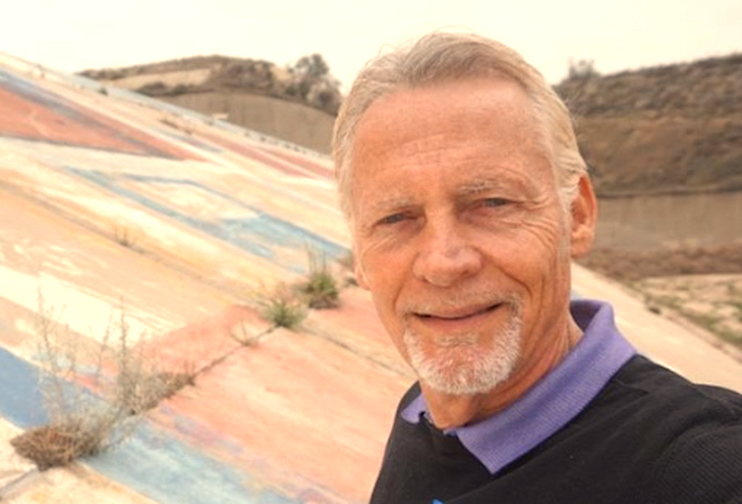
Scott M. Haskins, Art Conservator standing on the 120 feet tall and 664 feet long mural with a 40-degree slope, consulting with special interest groups, the Army Corp of Engineers, City officials, community groups, lawyers and the original artist.
The Orange County Register came out yesterday with an article that said the restoration of the Prado Dam Freedom Bicentennial Mural is supposed to begin next week. I was immediately contacted by several sources wondering if I was in charge or involved since for years I’ve been posting on social media about my consultations on the project. But in response to the question, the answer is, I don’t know if I’m still involved.
I was officially asked and established as the Head of the Project by the person in charge and, in fact, the Army Corp of Engineers at one point said that they would not approve the project going forward if our firm, FACLdidn’t handle or oversee the project. But there are a lot of politics involved and outside of my relationship with the original artist of the mural, Ron Kammeyer, and the legal representation for saving the mural, I’ve gotten smiles, compliments and handshakes but not meaningful contact.
Ron was the first to contact me to assure me. But the vibe is that its in the hands of bureaucrats who may proceed without the benefit of my expertise. Here is some background on the fight to save this symbol of freedom as a historical part of the nation’s Bicentennial in 1976.
Prado Dam Patriotic Mural near Corona Set to Start Restoration
The control of the Prado Dam located off of the 91 Freeway, (with its Bicentennial Freedom Mural on the dam’s spillway the size of six Mt. Rushmore monuments, at 120 feet tall and 664 feet long, with a 40-degree slope) is a complicated matter: the U.S. Army Corps of Engineers controls the Prado Dam, a water-control spillway that has never been used since it was built in the pre-WWII 1941; the water rights are controlled by the City of Riverside; the vegetation and landscape around-along-surrounding the dam is overseen by the City of Corona. 5 communities totaling 7 million people (Orange County and Inland Empire) feel emotionally connected with it as “theirs” (and their politicians have all had something to say about this political fight to save the mural or sand blast it as the Army Corp of Engineers has wanted to do.
But, as you might guess, the government’s technical arguments for sand blasting the mural are not logical, don’t make sense. The artist’s rights legislation, V.A.R.A. has been tossed around but the prevailing weighty matter is whether it was a good political move and was the population in the area in favor of saving or sand blasting. The public opinion has been in overwhelming to save it.
Visible to almost a 1/3 of a million drivers a day traveling east on the 91 Freeway, today’s faded liberty bell and 13 stars representing the 13 colonies tagged with graffiti, still evokes a patriotic response from people. The red- white-and-blue-mural painted by Corona High School students to mark the nation’s bicentennial in 1976 has as its slogan, “200 Years of Freedom.”
Kammeyer, one of the mural’s original designers and artists, tells the story of speaking with then, US President Gerald Ford, and said that it should be preserved, according to the Friends of Prado Dam Mural’s website. “It’s the largest patriotic mural in America, and one of the most beloved,” said landscape architect
Kammeyer and the Mural Conservancy of Los Angeles sued the Army Corp of Engineers in May 2015 seeking to stop their plans to sand blast off the graffiti and the mural. Soon after, as crews were ready to begin removing the faded mural, a federal judge issued an injunction temporarily blocking the Corps from altering or destroying the mural. The mural did not qualify for preservation as a national landmark, officials said in 2019. In April, U.S. District Judge Jesus G. Bernal dismissed the lawsuit and lifted the federal injunction. Though supporters of restoring the mural were initially alarmed, the organizers have since worked with Army Corps officials and with the expertise and help of Fine Art Conservation Laboratories and Scott M. Haskins to arrange for the mural to be fully restored, with work to begin later this year. Corps spokesperson Dena O’Dell said in April that the judge’s ruling means the federal agency “can proceed with removing and abating the lead-based paint on the Prado Dam mural.” Riverside County spokesperson Brooke Federico said that the county’s flood control district is “committed to working with federal and local partners to get the mural restored.”Federal and county leaders met with mural advocates to sign an agreement and to discuss a plan and timeline to begin the restoration. Earlier this year, Rep. Ken Calvert, R-Corona, secured $2.5 million to be used by the Army Corps of Engineers to remove paint and graffiti and begin the restoration, with aid from the Riverside County Flood Control and Water Conservation District, Orange County Water District and the Friends of the Prado Dam Mural.
On a Tuesday, Aug. 30, statement, Calvert — who once called the mural “more graffiti than mural” and a “bad image” — expressed his support. He called it “as a source of pride for Corona residents and everyone in our region.” “The desire to restore the mural to its original condition is something that unites people across the political spectrum, and I’m thrilled that I’ve been able to contribute along with the other stakeholders to make that restoration a reality,” Calvert said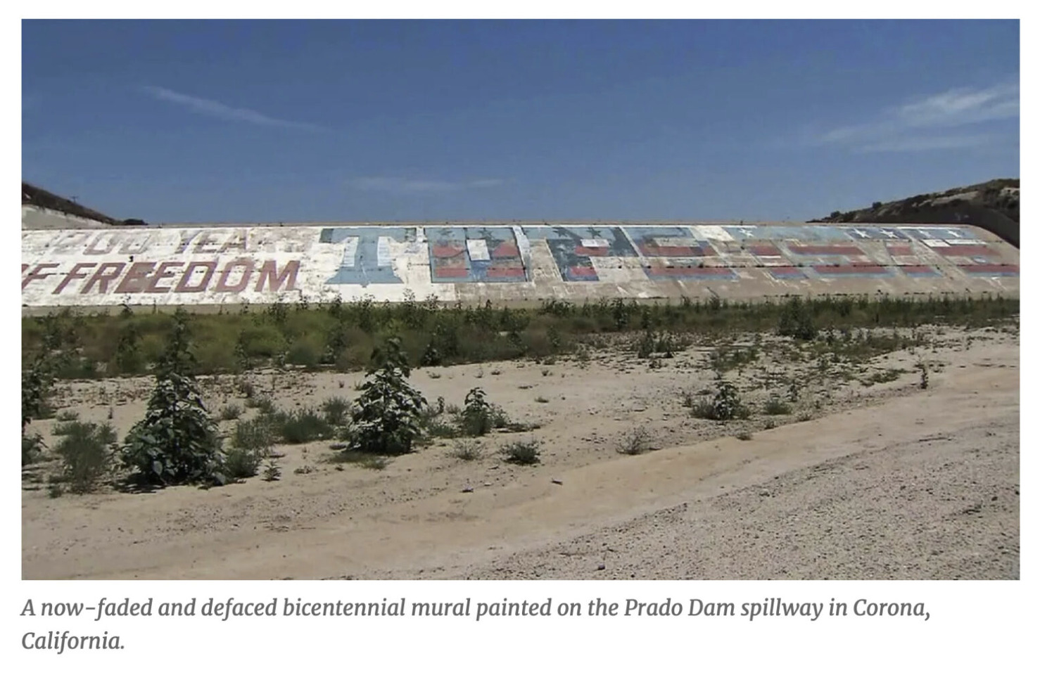 Kammeyer said he fought “tenaciously,” rounding up thousands of letters in support of keeping the mural. For me, (this) represents 20-plus years of struggle, of making that promise to our president. It reminds people of that moment in time.” Kammeyer said. The goal is to have the mural “completely restored, hopefully, by July 4 of 2023.” Peter Usle, from the Friends of the Prado Dam Mural which is leading fundraising efforts — said five city councils — Corona, Eastvale, Norco, Chino and Chino Hills — signed resolutions “in support of returning the mural to its former glory.” “Not only does it express the ideals of our nation, it’s also been accepted as public art, and unlike other monuments of its kind, no one’s face is on it. So when viewing it, it touches you directly,” Usle said. This beloved mural, like the 1976 Bicentennial itself, brings people together with the spirit of patriotism and like you can readily hear said from those who work and live in the area, I know I’m home when I see it.
_________________
Its a bit of a coup to get an article syndicated, and its certainly prestigious, as additional “proof” that the info and the author are considered far and wide authoritative and an expert in the field. So, enjoy and trust our content!! This article was syndicated for USA national redistribution.
When something is published, usually by a news source, and is made available through different venues for redistribution then it is said to be syndicated. Publications that are syndicated are usually considered of value as being from an expert, educational, new worthy or valuable for wide popular interest. See syndication page at the renowned publicity site: https://www.expertclick.com/NRWire/Releasedetails.aspx?id=275283
spacer
Groundbreaking event kicks off Prado Dam mural restoration with local leaders, advocates
September 9, 2022
NEWS RELEASE
Forty-six years after the Prado Dam bicentennial mural was initially painted, the mural will be restored to its bright red, white and blue hues. Supporters celebrated the upcoming mural restoration at a groundbreaking event on Thursday September 8 at the mural site.
The project is made possible through partnerships with several government agencies and community groups, including the Bicentennial Freedom Mural Conservancy, Friends of the Prado Dam Mural, Riverside County Flood Control and Water Conservation District, Riverside County Regional Park & Open-Space District, and the U.S. Army Corps of Engineers. The beloved mural’s restoration will result in a new generation of supporters of the iconic Inland Empire landmark.
“One of my major goals as I entered office was to work restore this important mural,” said Supervisor Karen Spiegel, District 2, a key champion of the mural’s restoration. “I have witnessed the community, elected officials, and my hometown friends and family come together in this effort. To see the restoration realized will bring much pride to our region.”
Due to environmental concerns of the lead-based paint commonly used in 1976 when the mural was originally painted, the U.S. Army Corps of Engineers has committed to removing the existing mural. For that reason, a coalition of nonprofits, local agencies, and the U.S. Army Corps of Engineers collaborated to restore the mural.
Representative Ken Calvert, Congressional District 42, was also an instrumental leader in securing a path to the mural’s restoration.
“I was proud to secure $2.5 million to support this effort because as someone who was born and raised in this community, I understand the significance of the bicentennial mural to the residents in Corona and the Inland Empire,” said Representative Calvert. “It is now my honor to celebrate this groundbreaking milestone, and I look forward to the completed restoration in the spring.”
The original Prado Dam mural spans 76,800 square feet and was completed in June 1976, by 30 high school students from Corona High School to celebrate our nation’s bicentennial. The bicentennial mural paint removal is slated for early fall by the U.S. Army Corps of Engineers. It will be restored to the original design by Spring 2023 using funds raised by the Friends of the Prado Dam Mural, the Bicentennial Freedom Mural Conservancy and contributions from local businesses.
To learn more about the Prado Dam bicentennial mural restoration, visit: http://friendsofthepradodammural.com/ or contact Peter Usle at peterusle@aol.com.
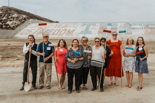
Caption: Original Prado Dam Mural painters participated in the groundbreaking ceremony at Prado Dam.

Caption: Local leaders including Riverside County Supervisor Karen Spiegel, Congressman Ken Calvert, County CEO Jeff Van Wagenen, Flood Control Chief Engineer Jason Uhley and U.S. Army Corps of Engineers Colonel Julie A. Balten participated in the groundbreaking ceremony at Prado Dam.
It’s all about dem BONES!
By Jody Robinson
There’s a certain mystique that comes alongside the signs which state “National Register of Historic Places.” Even more so, the places which are waiting to be named.
Occasionally in disrepair, like the Prado Dam Mural in Corona, California, these places hold significance to a great many, yet have often yet to be recognized for their cultural and historic significance. Status doesn’t matter to Jeff McCabe, owner of One Way Painting, based in Orange, California. Luckily enough, the pursuit of a singular passion has been enough to keep Jeff pushing for a complete repair and repaint of the Prado Dam.
The journey began in 2012, when Jeff passed by the mural on the 91 freeway, but unlike over 300,000 other drivers that see it on their daily commute, Jeff took notice of the state it was in.

“I wanted to repaint the dam after seeing it fall into disrepair,” he says. “It was being tagged. As a sign of our patriotism, it felt like people were disrespecting our flag and country.”
Jeff, like many others, was born in 1976. A Bicentennial Baby as his mom called him, the mural has always held a special place in his heart. The mural was originally painted the year he was born, by the students of Corona High School. Part of a school project and contest, Ron and Perry brought 30 of their friends along and over two weeks, painted the mural.
Celebrating America’s 200 years of freedom, the unveiling of the mural was part of the Bicentennial celebrations that took place all over the States. “Ten years in the making, with close to 60,000 events planned,” reporter Dave Mecham said “it was like the 4th of July on steroids, celebrated throughout the entire year.”
After years of attempted connections, Jeff finally made headway with the Army Corp of Engineers. And not too soon. By chance his brother Jim “saw online that the Corp was settling up to strip the mural, and that there was a group of the original artists, now in their 60’s, who were trying to save it.”
Joining forces, Jeff, Jim, and the former Corona High students formed the Bicentennial Freedom Mural Conservancy, whose sole purpose is to repaint the mural and preserve it indefinitely, for future generations to enjoy. Key major contributors include Dunn-Edwards, Rust-Oleam and Orange County-based Veteran Air.
“Upon completion of the repainting of the dam, there will be an unveiling, dedication and ribbon cutting ceremony.” A labor of love, like the first time around, the mural is still a symbol of American resiliency, hard work, and dedication. Just ask the moms who fed the original 30 students, or each individual private donation to cover labor and materials, insurance, equipment, worker’s compensation, and insurance. Mystique or no, the Prado Dam mural is here to stay.
spacer