
WE have a WATER CRISIS in the USA. Whether you are aware of it or not, our water supply is dire straights. This has been coming for some time. They have been systematically constructing this crisis for years. They started destroying our dams and manipulating our weather to create a crisis. I know your mind is screaming “CONSPIRACY THEORY”. That is what you are conditioned to think. You better get over that, and quick! Your world is about to cave in, due to your lack of diligence.
This is not just a water problem. It would be bad enough it only affected how much water we can drink or whether we are able to grow food. Those two factors right there are enough to give you nightmares. But, this also affects our POWER SUPPLY!! Electricity that is created by Water moving through dams will be suddenly cut off.
Think about how much we depend on electricity. Our grid is already pushed to the max. We have an outage in my Texas neighborhood every time there is a storm or wind. Our phones, TV, Lights, Heat, Air Conditioning all depend on Electricity to one degree or another.
That is why to me, the idea of putting EVERYBODY on a Cellphone and or Computer across the GLOBE and into an Electric Vehicle is insane? These idiots who think they are so much smarter than all of us…are they really too stupid to see the consequences??? Or are they just too greedy to care???
Anyway that is a topic for another Post. Today we are going to focus on the Water Crisis in the USA. If you have not already see my series entitled “It’s a DAM Shame” check it out below:
spacer
Its a DAM Shame – Part 1 ; Part 2; Part 3, Part 4, Part 5
spacer
We are going to take a look at what is currently going on with our nations DAMS and the rivers and lakes surrounding them.
Most of the articles included in this post are not printed here in full. You can visit their individual webpages by clicking on the title link. Only excerpts are included here, with a few exceptions. The information is shared here for educational purposes only. I take no credit for the material or the photos. Anything typed in green represents my comments or additions. This material is presented free of charge and I take no compensation from this webpage.
spacer

Today, it’s three-quarters empty, intentionally kept low because of concerns it could fail under the strain of too much water.
During “a big earthquake, you never know what’s going to happen, if this is going to hold,” said Samuel Santos, a longtime resident who frequently fishes near the dam.
Seismic instability and a spillway in need of “significant repair” led El Capitan to be added to a growing list of dams rated in poor condition or worse that would likely cause deaths downstream if they failed.
 The dam at El Capitan Reservoir is seen Friday, April 8, 2022, in Lakeside, California. AP PHOTO/GREGORY BULL
An Associated Press analysis tallied more than 2,200 high-hazard dams in poor or unsatisfactory condition across the U.S. — up substantially from a similar AP review conducted three years ago. The actual number is likely even higher, although it’s unclear because some states don’t track such data and many federal agencies refuse to release details about their dams’ conditions.
The nation’s dams are on average over a half-century old and often present more of a hazard than envisioned when designed because homes, businesses or highways have cropped up below them. Meanwhile, a warming atmosphere can bring stronger storms with heavier rainfall that could overwhelm aging dams.
“All of a sudden, you’ve got older dams with a lower design criteria that now can potentially cause loss of life if they fail,” said Del Shannon, an engineer who is president of the U.S. Society on Dams. (THIS DID NOT OCCUR ALL OF A SUDDEN!! They have known about this for at least 20 years. They have done nothing to correct the problem. They have actually done a lot to contribute to it.)
“The number of deficient, high-hazard dams is increasing,” he said, adding that without investment in upgrades, that number will continue to rise.
Decades of deferred maintenance has worsened the problem. But a changing climate and extreme floods — such as the one that caused the failure of two Michigan dams and the evacuation of 10,000 people in 2020 — have brought a renewed focus to an often overlooked aspect of America’s critical infrastructure.
The $1 trillion infrastructure bill signed last year by President Joe Biden will pump about $3 billion into dam-related projects, including hundreds of millions for state dam safety programs and repairs. (millions of dollars is just a spit in a can when applied to this issue. Trillions might have made a difference, even billions could help… million of dollars is a joke.)
It marks “a tremendous leap and jump of funding,” said Kayed Lakhia, director of the National Dam Safety Program at the Federal Emergency Management Agency.
Yet it’s still just a fraction of the nearly $76 billion needed to fix the almost 89,000 dams owned by individuals, companies, community associations, state and local governments, and other entities besides the federal government, according to a report by the Association of State Dam Safety Officials.
Isn’t it amazing how they can confiscate people land and entire city block of homes for eminent domain when they want to build a football stadium. But they can’t take control of dams that affect our nation’s waterways? Sadly, even if they did, they would do nothing more for those dams than they have for the ones already under their control/supervision.
spacer

___
The U.S. Army Corps of Engineers lists about 92,000 dams in its nationwide database, most of which are privately owned and regulated by states. Dams are classified according to the risk posed by failure, ranging from low to significant to high. A high hazard means lives could be lost if the dam fails.
Dams also are assessed by their condition. Those in the worst shape — categorized as poor or unsatisfactory — can have a variety of problems including cracks and erosion that could undermine a dam, or spillway outlets unable to release all the water after extraordinary rainfall.
The number of high-hazard dams in poor or unsatisfactory condition has risen partly because of stricter regulation. Some state programs, infused with millions of additional dollars, have stepped up inspections, reassessed whether old dams endanger new downstream developments and worked to identify dams long ago abandoned by their owners. Some also are updating the precipitation tools used to evaluate the risks.
New York has about twice the number of high-hazard dams in poor condition as it did in 2018, when the AP collected data for its earlier analysis. The increase came as officials pushed to assess all high-hazard dams that were previously unrated.
SO, what they are telling us is that these dams, that are currently listed as dangerous, have been at high hazard risk for a VERY LONG TIME, which makes the risk even greater that they are about to fail!!
spacer

The number of high-hazard dams in deficient condition in South Carolina rose by a third from 2018 to 2021, after lawmakers more than doubled annual funding for the state’s dam safety program. More than 70 dams failed in the state amid heavy rains in 2015 and 2016. Since then, South Carolina has ramped up staffing, undertaken more regular inspections and begun mapping potential flood zones for low-hazard dams to determine if they should be reclassified as high hazard.
“When you had a storm of that magnitude and you have it happen again the next year, and dams continue to fail, we’ve got to be able to provide a response,” said Jill Stewart, the state’s director of dam safety and stormwater permitting.
Rhode Island examined the capacity of all its dam spillways after five dams failed during a storm in 2010. A 2019 study found that a quarter of its high-hazard dams couldn’t hold up to a 100-year storm — an event with a 1% chance of happening any year — and 17% couldn’t pass a 500-year storm, which has a 0.2% chance of occurring in a year.
The state was sharing the findings with dam owners and could require some to upgrade their spillways to meet state regulations.
Many old dams “are undersized for the kind of storms that we’re getting today and will be getting in the future,” said David Chopy, administrator of the Office of Compliance and Inspection at the Rhode Island Department of Environmental Management.
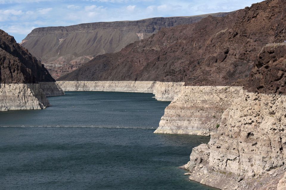
Since 2019, California regulators have downgraded four of San Diego’s water supply dams from fair to poor condition because of deterioration and concerns they could fail because of an earthquake or extraordinary rainfall. As a result, the high-hazard dams at El Capitan, Hodges and Morena reservoirs all are restricted to holding less than half their capacities. The dam at Lower Otay Reservoir, also high hazard and in poor condition, is not restricted.
The lower water means Santos, who has been coming to El Capitan Reservoir since childhood, can’t find relief from shade trees when he fishes from the receding banks. His children don’t want to join him because it’s so hot.
“It’s sad to see it, because it’s just like a duck pond compared to what it used to be,” said another longtime resident, Bob Neal, who said his father-in-law helped build the dam in the 1930s.
The dam’s poor condition also means less water is stored to prepare for drought, which has become particularly severe in the West. San Diego gets an average of just 10 inches of rain annually.
“These reservoirs are very important,” said Republican state Sen. Brian Jones, whose district includes the El Capitan and Lake Hodges dams. “We need to start spending the money on them to retrofit them, to get them up again back to full capacity.
Jones is among several lawmakers pushing the state to carry out a 2014 ballot proposition that authorized billions of dollars for reservoir projects. San Diego’s mayor also has urged the state to allot at least $3 billion for dam repairs statewide.
For many dams, problems develop gradually and risks can be reduced by temporary measures, such as lowering water levels, until repairs can be made, said Ryan Stack, chief engineer at Missouri’s dam safety program. (BUT, they are not making repairs. POOR MAINTENANCE IS THE MAJOR CONTRIBUTOR TO THE PROBLEM)
“Unsatisfactory doesn’t necessarily mean helicopters and bells-and-whistles and everything going off for an immediate crisis,” Stack said.
But the risk from old, inadequate dams has become painfully evident in recent years.
In 2019, a rural Nebraska dam failed under extreme pressure from a raging flood of ice chunks, killing a man whose home was beneath the dam. An independent investigation determined that state regulators should have classified the dam as “high hazard,” which could have led to a plan to increase its flood capacity and better warn residents downstream. The public utility that owned the dam agreed this year to a $2.5 million settlement for the man’s family while a lawsuit continues against the state. (How is it they can afford to pay out absorbedent settlements, but can’t afford to maintain, repair and update to avoid loss of life and property?)
In 2020, central Michigan’s Edenville Dam failed following heavy rainfall. The rupture unleashed a torrent on the Tittabawassee River, leading to the failure of Sanford Dam downstream and the evacuation of about 10,000 people. (How many of those people lost their homes and/or businesses and/or vehicles permanently?)
The high-hazard Edenville Dam, built in 1924, had been rated in unsatisfactory condition in 2018 and lost its federal hydropower license due to a variety of issues, including a spillway incapable of standing up to a severe flood. (Why was it not shut down?)
An investigatory report released Wednesday found that Edenville dam had deficiencies with its earthen embankment that could have been been caught and corrected if engineers had gone beyond visual inspections and conducted a more comprehensive review of the dam’s design and construction. Regulators across the country should learn from the Michigan failures, said John France, an engineer who led the investigation.
“No one has X-ray eyes,” France said Thursday. “You would have to look at the records, you would have to look at the test borings that were done and assimilate that all together.” (But, shouldn’t that be standard procedure when dealing with structures that support the nation’s infrastructure and can possibly cause risk to life and property to millions of people? If the don’t want the responsibility, they don’t need to own or operate a dam!)
After the dam failures, Michigan beefed up its 2022 budget with $19 million for dam safety, plus money to hire more regulatory staff. Democratic Gov. Gretchen Whitmer recently signed legislation providing an additional $250 million for dams, including about $200 million to repair those damaged by the 2020 floods.

The plan prioritizes high-risk dams “that can be ticking time bombs if they are not addressed,” said state Rep. Roger Hauck, a Republican whose district experienced flooding from the dam failures. “Dragging our feet or failing to get it done will only open the door to other catastrophes down the line.”
Other states also are pumping more money into dam safety. After Kansas exempted thousands of dams from state regulation in 2013, its allotment of annual federal dam safety funds plunged, leading to a decline in staffing and delays in handling permits and inspections. A budget passed by the Legislature this year will double state funding and staff for the dam safety office.
Facing a projected 20-year backlog of work, Missouri lawmakers last year added $75,000 to hire an additional dam safety engineer. But it’s taken 10 months to find someone qualified to fill the position. (10 months just to hire one engineer?? Meanwhile, nothing is being done to clear the backlog, and certainly nothing to resolve dam issues, since they only allotted money for the engineer.)
Addressing the problems posed by old, unsafe dams can be challenging. Repairs can be costly and take years to complete. Attempts to remove dams — and empty the lakes they hold back — can spawn legal battles and a public outcry from those who rely on them for recreation or to sustain nearby property values.
A pair of high-hazard dams built in the mid-1800s near Cleveland are among those in need of major repair. Upper Shaker Lake, commonly known as Horseshoe Lake, was drained as a precaution after it developed sinkholes and cracks. The cities of Cleveland Heights and Shaker Heights, which jointly manage the dams, last year approved a $28.3 million plan to remove Horseshoe Lake Dam, return the area to a free-flowing stream and rebuild Lower Shaker Lake Dam.
But the plan faces backlash from community members who formed a nonprofit to try to save Horseshoe Lake. They hired a law firm and engineering company, launched a fundraising drive and gathered about 2,000 online petition signatures.

“The lake is a beautiful, calming feature that is the central park of the Heights neighborhood,” said musician Bert Stratton, a resident helping to lead the efforts. “It’s where people come to congregate, and they have for over 100 years.”
The Northeast Ohio Regional Sewer District, which manages stormwater projects, said Horseshoe Lake provides little flood-control benefit and that the district won’t pay to rebuild it.
“People need to understand there is a major risk at this facility,” including the “probable loss of life if the dam blew out,” said Frank Greenland, the district’s director of watershed programs.
Decades of procrastination on repairs has led to the deterioration of other dams across the country. Some owners find it difficult to justify the costs of improving structures without facing an emergency.
There’s an attitude among some dam owners of “oh, we’ll take care of it next year; oh, we’ll take care of it in three years; oh, let’s put together a plan,” said Bob Travis, managing partner of Risk Management Matters LLC, a consultant for community associations. “Meanwhile, that dam is getting older and older and older.”
spacer
So, we have seen that the issues with our dams can cause serious and even deadly problems when our crazy weathers gets out of hand and dilapidated dams are overwhelmed by flooding and high winds.
We also have an opposite problem when our nation is hit with outrageous heat, wildfires, blistering winds and NO RAIN or Very Little Precipitation, be that rain or snow. Lets take a look at what our Drought situation looks like currently.
Here is the Drought map from 2021 for a comparison.
spacer
 United States Drought Data June 2021
spacer
HERE IS WHERE WE STAND THIS MONTH. MAY 2022

United States Drought Data May 2022
Drought and Flooding both impact our infrastructure. We are going to take a look at what is happening and how much worse it is getting. They can promise to throw money at the problem all they want. But, until that money is actually applied to work being down to FIX the problem, it means nothing. They can drag their feet with committees to study the need, inspections, calculations, meetings, hiring staff, struggling to hire staff, battling local laws and regulations, battling local citizens who protest, fighting in court with people who have been injured, and using the funds to pay huge settlements. Meanwhile, we could all die of thirst or be washed away in a flood while the dams remain in dangerously negligent disrepair.
spacer
Dam providing power to millions nears critically low water level
By Benjamin J. Hulac CQ-Roll Call (TNS)
Jan 12, 2022

AP PhotoWill Thelander, a partner in his family’s farming business, talks about expected water shortages in Arizona that will impact his operation in Casa Grande, Ariz., Thursday, July 22, 2021. The Colorado River has been a go-to source of water for cities, tribes and farmers in the U.S. West for decades. But climate change, drought and increased demand are taking a toll. The U.S. Bureau of Reclamation is expected to declare the first-ever mandatory cuts from the river for 2022. (AP Photo/Darryl Webb)
Glen Canyon Dam, completed in 1963 and brought online two years later, is at 27 percent capacity, the lowest since it was filled, Bureau of Reclamation Commissioner Camille Touton told the Senate Energy and Natural Resources Committee Tuesday.
“The levels at Lake Powell, we are operating in conditions that we’ve never operated before,” Touton said.
The Colorado River Basin, which feeds Lake Powell and powers the Glen Canyon Dam, is in a 22-year drought. Due to human-caused climate change, Earth’s atmosphere is warming, driving droughts to be more common and harsher, according to the NASA. (This is Climate Change propaganda. We have proven over and over that Scientists, NASA and DARPA are creating the climate change. It is not natural, nor is it caused by regular humans living their lives, nor is it caused by farm animals farting, nor too many people over populating the land.)
Touton’s testimony came a day after the National Oceanic and Atmospheric Administration said the U.S. experienced its fourth-warmest year on record in 2021, driven in part by the warmest December on record.
Citing a forecast the agency released last month, Touton said the levels of Lake Powell and Lake Mead, which powers the Hoover Dam, are both at historically low levels. The forecast projected Powell could drop below 3,525 feet by next month.
“This elevation is critical because it is just 35 feet above the minimum power production pool elevation of 3,490 feet,” Touton said in a written statement. That’s the lowest point at which Glen Canyon Dam can generate electricity.
“The continued extremely dry hydrology combined with already low reservoir levels means we are entering new and unpredictable operational conditions at Glen Canyon Dam, and other key facilities across the West,” she said.
Glen Canyon generates electricity for about 5.8 million people in Western states, according to 2019 figures from the bureau.
The agency announced last week it was changing its scheduled releases of water this year from the dam but would still release the same volume as part of an effort to maintain the minimum water level.
Asked by Sen. Martin Heinrich, D-N.M., how climate change was affecting the agency’s work, Touton said the bureau has installed new turbines that can operate at lower water levels, including at the Hoover Dam.
“When your fuel is based on water, you need to be able to look at it from both a water supply and also a hydropower perspective on how you keep those reservoirs up to protect both of those resources,” she said.
Sen. Mark Kelly, D-Ariz., aked about the potential Lake Mead could dry up and trigger a shutoff of Hoover Dam.
“Current modeling does not project Lake Mead to decline to dead pool,” Touton said, “within the next five years.”
The term “dead pool” describes the point at which turbines in a dam no longer turn.
© 2022 CQ-Roll Call, Inc.
Distributed by Tribune Content Agency, LLC.
spacer

Hoover Dam, one of the most iconic dams ever constructed, has reached its lowest water level in history.
Hoover Dam is an arch-gravity dam made of concrete and is located at the Black Canyon, Colorado. It was completed in 1936 to divert the Colorado river with the aim to efficiently provide water for agriculture, generate hydroelectric power and control flooding. The project was a pioneering construction that started during the Great Depression and provided occupation for numerous laborers. Nonetheless, many laborers lost their lives during its construction. Its height is about 220 meters and its reservoir capacity approximately 35 square kilometers. The dam currently provides water to 25 million people in the western United States. More on the history of the Hoover dam can be found here.
In early June 2021, the water level of the dam dropped to 326.6 meters above sea level setting the lowest level in history when the previous record was documented in 2016. The reservoir’s annual high and low Elevations from 1935 to 2020 can be found here.
The conditions of the reservoir are concerning since only one drop of more than 40 meters has been observed during the past 2 decades. It is currently only 37% full and the federal government officially declared a water shortage. The problematic situation derives from the extreme drought that has recently struck the Western United Stated. Droughts are natural phenomena that periodically occur and their impact has been controlled over the years, however, scientists agree that their frequency and intensity have increased, According to the U.S. Bureau of Reclamation, the current period is the driest one that the Western United States have experienced in 115 years.
As the conditions keep deteriorating, officials are implementing emergency measures. Arizona declared an emergency and ordered evacuations after 586.8 square kilometers of land were devastated by fires. The Regional Water Authority in Sacramento suggested that providers of water should drill more wells admitting that this is a temporary solution. Moreover, it recommended that customers voluntarily reduce their water consumption by 10%. In California, 41 out of the 58 counties declared a drought emergency.
At this point, officials anticipate July’s monsoon season to strike in the southwestern States and provide a temporal solution. “We’re just desperately looking to the forecast to see when the monsoon might show up,” Michael Crimmins, a University of Arizona climate scientist, stated.
(When did the United States start having a MONSOON SEASON?? We used to hear about those happening in foreign islands…not in the Continental Unites States of America. Just like Tsunami’s which were almost unheard of anywhere. And only recently they started announcing El Nino and Winter Bomb Cyclones.)
spacer
Las Vegas’ water intake now visible at drought-stricken Lake Mead
Lake Mead and Lake Powell upstream are the largest human-made reservoirs in the U.S., part of a system that provides water to more than 40 million people

spacer
![]()
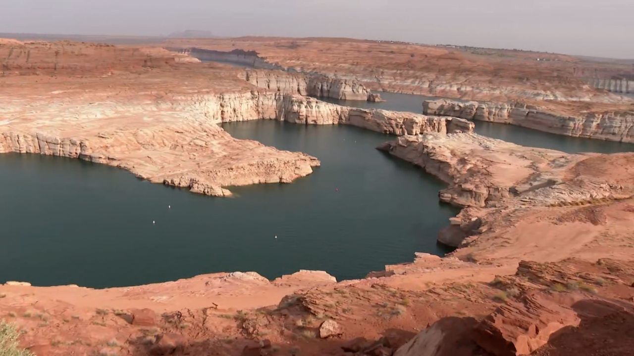
Lake Powell, the country’s second-largest reservoir, is drying up.
The situation is critical: if water levels at the lake were to drop another 32 feet, all hydroelectricity production would be halted at the reservoir’s Glen Canyon Dam.
The West’s climate change-induced water crisis is now triggering a potential energy crisis for millions of people in the Southwest who rely on the dam as a power source. Over the past several years, the Glen Canyon Dam has lost about 16 percent of its capacity to generate power. The water levels at Lake Powell have dropped around 100 feet in the last three years.
Bob Martin, deputy power manager for the Glen Canyon Dam, pointed toward what’s called the “bathtub ring” on the canyon walls. The miles of white rock represent this region’s problem.
“That’s where the water has bleached out the rock – and that’s how high the water was at one point,” Martin told CNN.
As water levels decline, so does hydropower production. The dam harnesses the gravitational force of the Colorado River’s water to generate power for as many as 5.8 million homes and businesses in seven states, including Nevada and New Mexico.
Bryan Hill runs the public power utility in Page, Arizona, where the federal dam is located, and likens the situation to judgment day.
“We’re knocking on the door of judgment day – judgment day being when we don’t have any water to give anybody.”
Forty percent of Page’s power comes from the Glen Canyon Dam. Without it, they’ll be forced to make up that electricity with fossil fuels like natural gas, which emits planet-warming gases and will exacerbate the West’s water crisis.
Loss of power at the dam would also mean higher energy costs for customers as the price of fossil fuels skyrockets.
“If nothing changes, in other words, if we don’t start getting some moisture for Page, in particular, we are looking at an additional 25 to 30% in power costs,” Hill told CNN.
The federal government – which technically owns the hydropower flowing through federally managed dams – sells the electricity to states for what is often far less than the commercial market price. In a worst-case scenario, the Interior Department projects the dam could stop producing power by January.
The agency is now weighing an emergency action that would buy the dam more time.

In a letter to seven Western states this month, the Interior Department recommended releasing less water from Lake Powell to downstream states this year. The proposal calls for holding back the equivalent of 42.6 billion gallons of water in Lake Powell, which will mean deeper cuts to the amount of water people can use in Arizona, California, Colorado, Nevada, New Mexico, Utah and Wyoming.
More than 110 billion gallons of water have already been held back so far this year.

Inside the Glen Canyon Dam, the current water level is still producing energy.
At the dam’s power plant there are eight generators. The force of water traveling through 15-foot diameter pipes hits and spins turbines which then generate power. If water levels at Lake Powell drop just another 32 feet, those generators will stop spinning.
The climate crisis is forcing both federal and state governments to make tough choices and take drastic measures just to keep both power and water flowing to Americans in the Southwest.
The Interior Department is expected to make a final decision on how to handle the dire situation at the dam by early May.
| The Daily Digest |
Mother nature reveals the dark secrets of Nevada’s Lake Mead
Zeleb.es – 1h ago
I am not impressed that they found a few bodies. After all this is VEGAS! You would expect a lot more. Heck, they found more bodies in little bitty Lake Como in Fort Worth, Texas.
What does concern me in all these photos is the level of the lake and how dry the ground looks. People these are our major reservoirs. Drought and Famine are at our door.

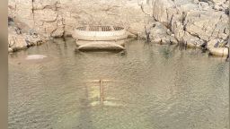
Historic drought at Lake Mead

Secrets at the bottom of the lake

Bones in a barrel (not the same barrel)
The police believe that the barrel may be from the 1980s based on the personal items inside the barrel. According to Lt. Ray Spencer from the Las Vegas Metro Police, it is believed that the individual inside the barrel was killed by a gunshot wound approximately 40 years ago.

It will be difficult to discover the identity of the remains
When the Las Vegas Metro Police addressed the local news station regarding the discovery, they said it would take a lot of work to discover the identity of the individual who was found in the barrel.
Photo: Fox5 News

Authorities expect to find more bodies
Lt. Spencer also said, “I would say there is a very good chance as the water level drops that we are going to find additional human remains.”

More human remains found
Lt. Spencer’s suspicions were correct, and on May 7, 2022, more human remains were found at Lake Mead. The Guardian reported that National Park Service rangers responded to a call that reported more human remains found in Callville Bay.

Found by two sisters paddleboarding

*(CNN) — Against the backdrop of the water crisis in the Colorado River Basin, where the country’s largest reservoirs are plunging at an alarming rate, California’s two largest reservoirs — Shasta Lake and Lake Oroville — are facing a similar struggle.
Years of low rainfall and snowpack and more intense heat waves have fed directly to the state’s multiyear, unrelenting drought conditions, rapidly draining statewide reservoirs.
And according to this week’s report from the US Drought Monitor, the two major reservoirs are at “critically low levels” at the point of the year when they should be the highest.
This week, Shasta Lake is only at 40% of its total capacity, the lowest it has ever been at the start of May since record-keeping began in 1977. Meanwhile, further south, Lake Oroville is at 55% of its capacity, which is 70% of where it should be around this time on average.
spacer

Shasta Lake is the largest reservoir in the state and the cornerstone of California’s Central Valley Project, a complex water system made of 19 dams and reservoirs as well as more than 500 miles of canals, stretching from Redding to the north, all the way south to the drought-stricken landscapes of Bakersfield.
Shasta Lake’s water levels are now less than half of historical average. According to the US Bureau of Reclamation, only agriculture customers who are senior water right holders and some irrigation districts in the Eastern San Joaquin Valley will receive the Central Valley Project water deliveries this year.
“We anticipate that in the Sacramento Valley alone, over 350,000 acres of farmland will be fallowed,” Mary Lee Knecht, public affairs officer for the Bureau’s California-Great Basin Region, told CNN. For perspective, it’s an area larger than Los Angeles. “Cities and towns that receive [Central Valley Project] water supply, including Silicon Valley communities, have been reduced to health and safety needs only.”
spacer
Consequences of Severe Drought and Climate Change Ripple Across California
A lot is at stake with the plummeting supply, said Jessica Gable with Food & Water Watch, a nonprofit advocacy group focused on food and water security as well as climate change. The impending summer heat and the water shortages, she said, will hit California’s most vulnerable populations, particularly those in farming communities, the hardest.
“Communities across California are going to suffer this year during the drought, and it’s just a question of how much more they suffer,” Gable told CNN. “It’s usually the most vulnerable communities who are going to suffer the worst, so usually the Central Valley comes to mind because this is an already arid part of the state with most of the state’s agriculture and most of the state’s energy development, which are both water-intensive industries.”
‘Only 5%’ of water to be supplied
Lake Oroville is the largest reservoir in California’s State Water Project system, which is separate from the Central Valley Project, operated by the California Department of Water Resources (DWR). It provides water to 27 million Californians and 750,000 acres of farmland.
Last year, Oroville took a major hit after water levels plunged to just 24% of total capacity, forcing a crucial California hydroelectric power plant to shut down for the first time since it opened in 1967. The lake’s water level sat well below boat ramps, and exposed intake pipes which usually sent water to power the dam.
Although heavy storms toward the end of 2021 alleviated the lake’s record-low levels, resuming the power plant’s operations, state water officials are wary of another dire situation as the drought worsens this summer.
“The fact that this facility shut down last August; that never happened before, and the prospects that it will happen again are very real,” California Gov. Gavin Newsom said at a news conference in April while touring the Oroville Dam, noting the climate crisis is changing the way water is being delivered across the region.
According to the DWR, Oroville’s low reservoir levels are pushing water agencies relying on the state project to “only receive 5% of their requested supplies in 2022,” Ryan Endean, spokesperson for the DWR, told CNN. “Those water agencies are being urged to enact mandatory water use restrictions in order to stretch their available supplies through the summer and fall.”
The Bureau of Reclamation and the DWR, in concert with federal and state agencies, are also taking unprecedented measures to protect endangered winter-run Chinook salmon for the third drought year in a row. Reclamation officials are in the process of securing temporary chilling units to cool water down at one of their fish hatcheries.
Both reservoirs are a vital part of the state’s larger water system, interconnected by canals and rivers. So even if the smaller reservoirs have been replenished by winter precipitation, the plunging water levels in Shasta and Oroville could still affect and drain the rest of the water system.
The water level on Folsom Lake, for instance, reached nearly 450 feet above sea level this week, which is 108% of its historical average around this time of year. But with Shasta and Oroville’s low water levels, annual water releases from Folsom Lake this summer may need to be bigger than normal to make up for the other reservoirs’ significant shortages.
California depends on storms and wintertime precipitation to build up snowpack in the Sierra Nevada, which then gradually melts during the spring and replenishes reservoirs.
Facing back-to-back dry years and record-breaking heat waves pushing the drought into historic territory, California got a taste of the rain it was looking for in October, when the first big storm of the season pushed onshore. Then in late December, more than 17 feet of snow fell in the Sierra Nevada, which researchers said was enough to break decades-old records.
But precipitation flatlined in January, and water content in the state’s snowpack this year was just 4% of normal by the end of winter.
Further down the state in Southern California, water district officials announced unprecedented water restrictions last week, demanding businesses and residents in parts of Los Angeles, Ventura and San Bernardino counties to cut outdoor watering to one day a week beginning June 1.
Gable said as California enters a future much hotter and drier than anyone has experienced before, officials and residents need to rethink the way water is managed across the board, otherwise the state will continue to be unprepared.
“Water is supposed to be a human right,” Gable said. “But we are not thinking that, and I think until that changes, then unfortunately, water scarcity is going to continue to be a symptom of the worsening climate crisis.”
spacer
So, there you have it. This weather manipulation and water crisis is designed to get the general public to accept that water is not a RIGHT. That water is not provided by GOD, but by the state, who will decide who gets it and where. Capisce?
The water supply forecast for the spring and summer of 2022 is below average for almost all Oregon watersheds, except for some in northwest Oregon, where forecasts are near-normal. Most of the areas projected to be below average are already stressed due to drought conditions for much of the past 2 years.
Precipitation so far this water year (October 1, 2021 to present) is highly variable around the state but mostly below average. Portions of northwest and northeast Oregon are near or above average, while central, southeast, and southwest Oregon are below average. Seasonal precipitation is particularly low relative to average for central and southeast Oregon. Mountain snowpack has been nearly unchanged since early January. February and March are typically months where snowpack continues to accumulate, but only the northern Cascades had minor increases. As of early April, several snow monitoring stations in south-central and southeast Oregon already had complete melt-out for the season. Seasonal snowpack was below normal for all but the far-northern Cascades in the vicinity of Mt. Hood.
Substantial precipitation and mountain snow accumulation is possible through April and May. However, amounts are unlikely make a significant dent in seasonal deficits to long-term precipitation, snowpack, soil moisture, and reservoir storage, especially for the southern half of Oregon. The following counties already have received drought declarations from the Governor’s office: Crook, Gilliam, Harney, Jackson, Jefferson, Klamath, and Morrow. Additional counties are likely to request drought declarations this spring.

The next update to this outlook will be issued by May 10, 2022.
Precipitation for the 2022 water year thus far (Oct 1, 2021 through Mar 7, 2022) ranges from 55 to 100 percent of average in Oregon. The lowest totals relative to average have been in southwest Oregon, areas that have also been below average for much of the past two years. The highest totals, 90 to 100 percent, have been in the northern Cascades and in portions of northeast Oregon.
March precipitation was below average for all but northwest and north-central Oregon, ranging from 10 to 100 percent of average. Precipitation totals were near zero for much of south-central, central, and eastern Oregon, all areas that are already experiencing extreme or exceptional drought. March temperatures were 2 to 5 degrees above average for most of the state, including all of the Cascade Range.

www.nwrfc.noaa.gov/water_supply/wy_summary/wy_summary.php
NOAA NWS – California-Nevada River Forecast Center (Klamath basin)
www.cnrfc.noaa.gov/water_resources_update.php
As of early April, mountain snowpack is near average for the northern Cascades, including 116 percent of average for the Hood-Sandy-Lower Deschutes area, but below average for the rest of the state and especially so for the southern half of the state, ranging from 20 to 50 percent. Minimal snow accumulation has occurred since early January, apart from areas around Mt. Hood in the northern Cascades, so the percent-of-median values have dropped at most SNOTEL snow monitoring stations in February and March. Additionally, most of
the existing snowpack in southern Oregon melted in late March and early April.
spacer

NOAA National Weather Service – Northwest River Forecast Center
www.nwrfc.noaa.gov/snow/
USDA Natural Resources Conservation Service
www.nrcs.usda.gov/wps/portal/nrcs/main/or/snow/
The Climate Prediction Center produces monthly and seasonal outlooks, in which there is a weighing of the odds of near normal, above normal, or below normal temperatures and precipitation.
The April outlook shows a slightly-enhanced likelihood of below-average temperatures and above-average precipitation for northern Oregon, with equal chances for temperatures and precipitation in southern Oregon.
The outlook for May through July indicates a slightly enhanced probability of below-average precipitation for all of Oregon. For temperatures, there is a slightly-enhanced probability of above-average temperatures for southeast Oregon, with equal chance of near, above or below average for the rest of the state.
Visit www.cpc.ncep.noaa.gov for more about seasonal outlooks.
spacer


Storage for most irrigation reservoirs across the state is much below average, with multiple reservoirs in central and southwest Oregon at record low levels coming into this water year. The combination of low carryover storage from last water year and below-average precipitation and snowpack so far this water year means that reservoir storage is unlikely to be sufficient to meet all demands this summer, especially for the southern half of the state. While some reservoirs have refilled with recent precipitation and snowmelt, major deficits
remain as of early April.
Owyhee Reservoir, the largest irrigation project in the state, has storage of about 305,208 acre-feet, 43 percent of capacity, as of early April. This is 59 percent of average for this time of year.
Reservoir data is provided by the Natural Resources Conservation Service, the Bureau of Reclamation, and the
US Army Corps of Engineers.
Additional reservoir information:
www.nwd-wc.usace.army.mil/nwp/teacup/willamette/
www.usbr.gov/pn/hydromet/select.html
www.wcc.nrcs.usda.gov/basin.html
Water supply forecasts for April-September runoff volume are below average for most of the state, most notably for central and almost all of southern Oregon. The only area near average is northwest Oregon, especially watersheds draining the northern Cascades in the vicinity of Mt. Hood.
The forecast for the Columbia River at The Dalles, which is a good index of conditions across the Columbia Basin, is 97 percent of average for April-September, a decrease of 1 percent from a month ago

NOAA National Weather Service – Northwest River Forecast Center: www.nwrfc.noaa.gov/ws/
USDA Natural Resources Conservation Service: www.wcc.nrcs.usda.gov/wsf/

Americans wondering whether a nearby dam could be dangerous can look up the condition and hazard ratings of tens of thousands of dams nationwide using an online database run by the federal government.
 © Provided by Associated PressFILE – Water starts to flow from the lower jet flow gates at Hoover Dam near Boulder City, Nev., Thursday June 11, 1998, during testing of the newly installed jet flow gates. Americans wondering whether a nearby dam could be dangerous can look up the condition and hazard ratings of tens of thousands of dams nationwide using an online database run by the federal government. But they won’t find the condition of Hoover Dam, which impounds one the nation’s largest reservoirs on the border of Nevada and Arizona. (AP Photo/Lennox McLendon, File)
But they won’t find the condition of Hoover Dam, which impounds one the nation’s largest reservoirs on the border of Nevada and Arizona. Nor is there any condition listed for California’s Oroville Dam, the country’s tallest, which underwent a $1 billion makeover after its spillway failed.

National Inventory of Dams.
The lack of publicly available data about potentially hazardous dams has raised concern among some experts.
“These structures impact people, and this is what we’re obviously most worried about. So it is important to share this information,” said Del Shannon, a Colorado-based engineer who has assessed hundreds of dams and is president of the U.S. Society on Dams.
For much of the past couple of decades, the U.S. Army Corps of Engineers declined to reveal the conditions of dams in the National Inventory of Dams — which it maintains — citing security concerns stemming from the Sept. 11, 2001, terror attacks.
But in a move toward greater transparency, the Corps launched an updated website late last year that includes hazard ratings and condition assessments for more than one-quarter of the roughly 92,000 structures.
Yet the status of many dams remains a mystery. That’s because some federal agencies failed to update their data. The Corps also allowed federal agencies and states to restrict the release of information about the dams they oversee, and some continue to do so citing terrorism concerns.
The Associated Press used information obtained by public records requests to states to supplement data in the National Inventory of Dams, tallying over 2,200 high-hazard dams that are in poor or unsatisfactory condition in 48 states and Puerto Rico. But the conditions remain unknown for more than 4,600 high-hazard dams that could cause a loss of life if they fail.

Dam conditions typically are categorized as satisfactory, fair, poor or unsatisfactory.
In the Corps’ database, nearly two-thirds of the 18 federal entities that own or oversee dams provided no condition assessments. That includes the largest federal regulator of dams, the Federal Energy Regulatory Commission, which oversees more than 1,750 dams in 42 states. A FERC spokeswoman said the agency is overhauling its assessment process and intends to have conditions available this summer.

The Corps also declined to include condition assessments for the roughly 740 dams it owns, which include some of the largest in the nation. Instead, the agency posted its own “risk assessments,” ranging from “very low” to “very high.”

Garrison Dam, which constrains the Missouri River in North Dakota to form one of the nation’s largest reservoirs, is described in the database as “safe” but “high risk.” The Corps says the dam’s failure could trigger a cascading failure of downstream dams resulting “in swift, deep, and life-threatening flooding in numerous communities.”
No other entity uses the Corps’ risk-rating system, making it hard to compare the Corps’ dams to others. The Corps said it uses the risk categories to make repairs “in the most effective manner within a constrained budget.”
“The risk assessment information that we’re sharing is actually better information to help people be prepared for a potential issue at a dam,” said Rebecca Ragon, the Corps’ National Inventory of Dams manager.
The AP’s review also found that some federal departments lack consistent policies for releasing dam data. The Bureau of Land Management and the U.S. Fish and Wildlife Service— both part of the U.S. Department of Interior — disclosed hazard and condition details for their dams.
But the department’s Bureau of Reclamation, which oversees 430 dams in the West, denied the AP’s public records request for dam conditions, citing a legal exemption for “information compiled for law enforcement purposes.” The bureau said in an email that disclosing dam conditions “would compromise the protection of our facilities and allow targeted attacks of critical infrastructure.”
Data from some states is also limited or missing.
Alabama has no agency to regulate dams, so there are no condition or hazard ratings for its roughly 2,200 dams.
Illinois doesn’t assign condition ratings, because lumping dams into categories “is terribly subjective” and doesn’t “have enough value to justify the resources that it takes to do it,” said state dam safety engineer Paul Mauer Jr. However, the state works with dam owners to make needed repairs.
New Jersey and Texas provided AP a total number of poor or unsatisfactory high-hazard dams but did not identify them by name. New Jersey has not released dam conditions but plans to do so by the end of May under a recent policy change. Texas declined to release hazard classifications, citing a state law that keeps confidential the “technical details” of critical infrastructure that’s vulnerable to terrorism.
The National Inventory of Dams contains neither the hazard classification nor a condition for the Rockwall-Forney Dam, which impounds Lake Ray Hubbard to supply water to more than 1 million people in the Dallas area.
A 2021 inspection document provided to the AP by Dallas shows the dam is classified as high hazard and has several issues, including a fractured floodgate and a large void in the rocks lining the left side. A more in-depth inspection report isn’t complete.
Though an overall condition assessment is not available, “none of these things are of immediate concern,” said Sally U. Mills-Wright, assistant director for water production at Dallas Water Utilities.
Without access to information, it’s hard for the public to verify that.
Because dam failures carry big consequences, the public should be made aware of a dam’s hazard rating and what lies in its downstream flood zone, said Travis Attanasio, a former dam inspector who is president-elect of the Texas section of the American Society of Civil Engineers.
spacer
“You may not necessarily be in flood plain, but if a dam were to break, you could still be facing a lot of water,” he said.
NOW, this Water Crisis is certainly not limited to the US. Like all the issues of today, it is a GLOBAL ISSUE. Don’t you find that alarming that EVERY PROBLEM TODAY IS A GLOBAL PROBLEM? That is not natural or organic.
Yes, I understand that we all share the world, and we should care about what is happening in other nations. We need to help carry the burdens of those less fortunate. I believe with all my heart that the people of the United States have always believed and practiced that truth. At least the ones who KNOW GOD. Granted we are probably no longer the majority. BUT, throughout the history of the United States we have always been the first to send aid, send missionaries, send money. Don’t let them remove that truth from your memory.