Dear People… we are living in the last of the last days. If you don’t think we are currently living in tribulation you cannot be paying attention. The crazy life you are trying to eek out for yourself has kept you distracted from the reality around you. You are too busy to recognize the actual events occurring around you, let alone the signs coming from God.
Time is not eternal. It has set limits. The time for this current dispensation is rapidly coming to a close. As God prepares to separate the goats from the sheep and move His people to the next level He is putting the WORLD into a time of TESTING. He is shaking the sheaves over the threshing floor. We are in a time of SHAKING. God want to see who truly belongs to HIM and who will be joining the Fallen in the pits of Hell.
Inspite of what its claimed in the media, the level of Seismic Activity we are witnessing is not “normal”. Anyone over 60 years old can tell you, we have NEVER seen anything like this before. When I was growing up the only place in America that ever had earthquakes was California. Now they are experienced in every part of our nation and all around the world.
When I was growing up, there were very few places where volcanos erupted. Places like Hawaii, Japan, Indonesia.. but now they are going off all over.
We are seeling landslides, flooding, sinkholes, cracks in the earth, and even mountains sinking. The elite are using these events to coral people into submitting to their “Climate” Agenda. Giving up your rights for the empty promise of safety they cannot provide is not a viable answer.
God is still in control. This should be evident by the low numbers of deaths related to these events. When you really think about these catastrophes it is amazing that more people have not been killed.
You can take comfort in the truth that GOD is in control and that what is happening was already prophesied in His word.
Hebrews 12
Him that speaketh from heaven…26 Whose voice then shook the earth: but now he hath promised, saying, Yet once more I shake not the earth only, but also heaven.
27 And this word, Yet once more, signifieth the removing of those things that are shaken, as of things that are made, that those things which cannot be shaken may remain.
Haggai 2
…Be strong, all ye people of the land, saith the Lord, and work: for I am with you, saith the Lord of hosts:
5 According to the word that I covenanted with you when ye came out of Egypt, so my spirit remaineth among you: fear ye not.
6 For thus saith the Lord of hosts; Yet once, it is a little while, and I will shake the heavens, and the earth, and the sea, and the dry land;
7 And I will shake all nations, and the desire of all nations shall come: and I will fill this house with glory, saith the Lord of hosts
Isaiah 40
3 The voice of him that crieth in the wilderness, Prepare ye the way of the Lord, make straight in the desert a highway for our God.
4 Every valley shall be exalted, and every mountain and hill shall be made low: and the crooked shall be made straight, and the rough places plain:
5 And the glory of the Lord shall be revealed, and all flesh shall see it together: for the mouth of the Lord hath spoken it.
Do not allow FEAR to enter into your spirit. Fear has torment. Fear does not come from God. It comes from the DECEIVER/the ADVERSARY/the FATHER OF ALL LIES. God promises to give you peace. Peace that passes all understanding. Peace in the mist of the Storm. “Yea, though I walk through the valley of the shadow of death, I will fear no evil for though art with me. They rod and they staff they comfort me.”
Get as close as you can to God. Put your trust in HIM and nothing else. He will walk you through anything that you go through. I promise.
spacer
Millions Could Be Washed Away
RESTORED: 10/6/26 TAGS: La Palma, volcanic activity, Earthquakes, Tsunami, Tsunami Travel Times, Atlantic Ocean, Pacific Ocean, Fault Lines, Flooding, Canary Islands, US East Coast, US West Coast, New Madrid Fault Line, Fracking, NOAA, NAFTA, Super Highway, Nuclear Power Plants, Dams, Geo-Magnetic Storms, CME, Electro-Magnetic Waves, Frequencies, Sound Waves, Geo Engineering, Weather Manipulation, Glaciers, Global Warming, … Click Here to Read More

10/04/2026 — STRANGE THINGS found as seismic activity spreads — ANCIENT HIDDEN SITES having EQ’s
 Worldwide Earthquakes — LIVE
Real-time interactive map of earthquakes worldwide, updated live from EMSC/SeismicPortal. Filter by region, country, magnitude, …
Total Number of Earthquakes in 2020 (VolcanoDiscovery)
According to VolcanoDiscovery’s 2020 earthquake archive, there were 208,257 earthquakes below magnitude 2 recorded worldwide in 2020, plus additional quakes of higher magnitudes, for a total of 347,009 earthquakes of all magnitudes recorded in 2020 VolcanoDiscovery.
According to the VolcanoDiscovery 2021 archive, there were 27,805 earthquakes worldwide in 2021 of magnitudes up to 7.0 Volcanoes & Earthquakes.
Breakdown by magnitude (VolcanoDiscovery, Jan–Dec 2021) Volcanoes & Earthquakes
- Magnitude 7.0+: 2 quakes
- Magnitude 6.0–6.9: 11 quakes
- Magnitude 5.0–5.9: 166 quakes
- Magnitude 4.0–4.9: 1,172 quakes
- Magnitude 3.0–3.9: 3,764 quakes
- Magnitude 2.0–2.9: 7,489 quakes
- Below magnitude 2.0: 15,201 quakes (generally not felt by people)
Total: 27,805 earthquakes (all magnitudes recorded in the archive) Volcanoes & Earthquakes.
Total Number of Earthquakes in 2022 (VolcanoDiscovery)
- 11 quakes above magnitude 7
- 119 quakes between magnitude 6 and 7
- 1,728 quakes between magnitude 5 and 6
- 20,746 quakes between magnitude 4 and 5
- 45,057 quakes between magnitude 3 and 4
- 101,518 quakes between magnitude 2 and 3
- 285,888 quakes below magnitude 2 that people normally don’t feel.
VolcanoDiscovery’s 2022 earthquake archive records 15,438 total earthquakes worldwide of all magnitudes for the year VolcanoDiscovery.
According to the USGS and other seismic databases, 15,438 earthquakes of magnitude 2.5 or greater were recorded worldwide in 2022 grokipedia.com.

Worldwide earthquake counts for 2023 vary by magnitude threshold: USGS recorded 16,178 earthquakes of magnitude 4.0+ and VolcanoDiscovery reported 499,303 total earthquakes across all magnitudes.
Different agencies report different totals because they use different minimum magnitudes and detection methods.
Final Consolidated View
- All magnitudes: ~499,303 earthquakes worldwide (VolcanoDiscovery).
- Magnitude ≥4.0: ~16,178 earthquakes (USGS).
- Magnitude ≥6.0: ~129 earthquakes (CENC).
These figures reflect different cataloging standards but collectively describe global seismic activity in 2023.
Worldwide, 2024 recorded between 14,132 (USG) and 547,533 (VolcanoDiscovery) earthquakes, depending on the magnitude threshold used.
The USGS ComCat catalog counted 14,132 earthquakes of magnitude 4.0+, while broader monitoring sources such as VolcanoDiscovery reported 547,533 total earthquakes, including microquakes below magnitude 2.
Breakdown by Magnitude (2024)
USGS ComCat (M4+)
|
VolcanoDiscovery (All Magnitudes)
|
Firenzemeteo (M2.5+)
|
WORLDWIDE REPORT FOR 2025
In 2025, global earthquake counts ranged from about 8,445 M4.5+ events (USGS) to 696,674 total recorded quakes of all magnitudes (VolcanoDiscovery).
Summary of Reported 2025 Earthquake Totals
Different agencies report different totals depending on magnitude thresholds and cataloging methods:
. USGS (M4.5+ earthquakes)
|
VolcanoDiscovery (all magnitudes)
|
PlainQuake (M4+ earthquakes)
Firenzemeteo (M2.5+ earthquakes)
|
Final Note: The most comprehensive count for 2025 is the VolcanoDiscovery total of 696,674 earthquakes, which includes all magnitudes. VolcanoDiscovery
SPACER
2024 547,533
2025 696,674
NOW, LET’S LOOK AT THE MONTHLY REPORT FOR 2026
spacer
Worldwide Earthquakes in January 2026
In January 2026, 8,848 earthquakes were recorded worldwide, with the largest being a magnitude 6.7 near Tobelo, Indonesia on 10 January earthquake.now.
Key Statistics
- Total events: 8,848 earthquakes of all magnitudes earthquake.now
- Average per day: ~285 events earthquake.now
- The United States recorded the highest number of events (7,965), followed by Puerto Rico (183), Russia (67), Indonesia (65), and the Philippines (60) earthquake.now.
earthquake.nowEarthquakes in the United States, January 2026 — 7965 RecordedJan 1, 2026 · How many earthquakes hit the United States in January 2026? 7965 earthquakes were recorded in the United States …
Global Earthquakes in February 2026
In February 2026, 7,278 earthquakes were recorded worldwide, including one magnitude‑7.1 event in Malaysia and 11 quakes of magnitude 6.0 or greater .
Overall statistics
- Total events (all magnitudes): 7,278 earthquakes earthquake.now
- Average per day: ~260 events earthquake.now
- Magnitude distribution (≥2.0):
- M7.0+: 1 quake
- M6.0–6.9: 11 quakes
- M5.0–5.9: 133 quakes
- M4.0–4.9: 1,172 quakes
- M3.0–3.9: 4,979 quakes
- M2.0–2.9: 10,915 quakes VolcanoDiscovery
- Depth: 92% shallow (<70 km), 7% intermediate, 1% deep earthquake.now
- Most active countries: United States (6,467 events), Puerto Rico (117), U.S. Virgin Islands (85), Japan (62), Russia (58) earthquake.now
Summary: February 2026 saw a high but typical global seismic activity level, with the United States recording the highest number of events, 6,467 earthquake.now+1.
Worldwide Earthquakes in March 2026
In March 2026, 9,803 earthquakes were recorded worldwide — the largest being a magnitude 7.5 quake near Neiafu, Tonga on 24 March earthquake.now.
Global totals and activity
- Total events: 9,803 earthquakes of all magnitudes earthquake.now.
- Daily average: ~316 events/day earthquake.now.
- Magnitude distribution:
- M ≥ 7: 2 events
- M 6.0–6.9: 15 events
- M 5.0–5.9: 161 events
- M 4.0–4.9: 1,450 events
- M 3.0–3.9: 5,818 events
- M 2.0–2.9: 12,479 events VolcanoDiscovery.
- Depth: 91% shallow (<70 km), 8% intermediate (70–300 km), 1% deep (>300 km) earthquake.now.
- Most active regions: United States (8,825 events), Puerto Rico (157), Japan (83), U.S. Virgin Islands (69), Russia (60) earthquake.now.
Summary: March 2026 saw a high seismic activity level, with over 9,800 recorded quakes globally, the most active region once again was the United States with 8,825 events.
Total Number of Earthquakes in March 2026 Worldwide
In March2026 a total of 9,803 earthquakes were recorded worldwide earthquake.now+1.
- Magnitude distribution:
- M ≥ 7.0: 2 events
- M 6.0–6.9: 15 events
- M 5.0–5.9: 161 events
- M 4.0–4.9: 1,450 events
- M 3.0–3.9: 5,818 events
- M 2.0–2.9: 12,479 events VolcanoDiscovery
- Most active regions: United States (8,825 events), Puerto Rico (157), Japan (83), U.S. Virgin Islands (69), Russia (60) earthquake.now.
Once again, the most active area was the United States with 8,825 earthquakes.
Total Number of Earthquakes in April 2026 Worldwide
Total number of earthquakes in April of 9,611 were recorded worldwide earthquake.now+1.
According to the Earthquake.now archive, this figure represents an average of about 320 earthquakes per day globally earthquake.now. The month’s largest event was a magnitude 7.8 earthquake near Ternate, Indonesia on 1 April 2026, at a depth of 10 km earthquake.now.
Breakdown by Magnitude Range earthquake.now
- Magnitude -2: 56 events
- Magnitude -1: 333 events
- Magnitude 0: 2,094 events
- Magnitude 1: 4,450 events
- Magnitude 2: 1,550 events
- Magnitude 3: 454 events
- Magnitude 4+: 674 events
- Magnitude 5+: 164 events
- Magnitude 6+: 11 events (including 2 events ≥7.0) VolcanoDiscovery
- Most active regions: United States (8,634 events), Puerto Rico (172), U.S. Virgin Islands (129), Indonesia (124), and Japan (66) earthquake.now.
Once again, the most active region was the United States with 8,634 earthquakes
Worldwide Earthquakes in May 2026
In May 2026, 9,058 earthquakes were recorded globally, with the largest being a magnitude 6.9 quake near Calama, Chile, on 25 May earthquake.now.
- Magnitude distribution (Earthquake.now) earthquake.now:
- M ≥ 6: 12 events
- M 5.0–5.9: 295 events
- M 4.0–4.9: 2,041 events
- M 3.0–3.9: 4,180 events
- M 2.0–2.9: 1,551 events
- M < 2.0: 1,080 events
- Most active regions: United States (8,197), Puerto Rico (173), U.S. Virgin Islands (60), Japan (57), Chile (56) earthquake.now
June 2026 Global Earthquake Statistics — VolcanoDiscovery Archive
According to VolcanoDiscovery’s June 2026 earthquake archive, there were 49,247 earthquakes worldwide of magnitudes up to 7.8 during that month VolcanoDiscovery.
Breakdown by magnitude VolcanoDiscovery
- ≥ 7.0: 3 quakes
- 6.0–6.9: 18 quakes
- 5.0–5.9: 189 quakes
- 4.0–4.9: 1,580 quakes
- 3.0–3.9: 6,410 quakes
- 2.0–2.9: 14,136 quakes
- < 2.0: 26,911 quakes (generally not felt by people)
Strongest event VolcanoDiscovery
- Magnitude 7.8 — Celebes Sea, 50 km SW of Malapatan, Philippines.
Context
This total includes all recorded quakes in the month, from minor tremors to major events. The majority were below magnitude 2, which are typically imperceptible to humans. The archive also provides a detailed list and map of each quake, including date, time, magnitude, depth, and nearest volcano or tectonic feature VolcanoDiscovery.
VolcanoDiscovery’s archive and USGS data show that in June 2026, the United States recorded thousands of earthquakes of all magnitudes, with tens of thousands of smaller events detected by seismic networks.
SPACER
Worldwide Earthquakes in July 2026
In July 2026, there were over 43,000 recorded earthquakes globally, including one magnitude‑7.3 quake and ten magnitude‑6+ events, with the largest being a M7.3 offshore Chiapas, Mexico on 17 July VolcanoDiscovery+1.
Global Statistics
According to VolcanoDiscovery’s July 2026 archive, 43,929 quakes were recorded worldwide with magnitudes up to 7.3 VolcanoDiscovery:
- ≥7.0: 1 quake
- 6.0–6.9: 10 quakes
- 5.0–5.9: 244 quakes
- 4.0–4.9: 1,962 quakes
- 3.0–3.9: 6,501 quakes
- 2.0–2.9: 12,150 quakes
- <2.0: 23,061 quakes (mostly imperceptible)
- Most active regions: United States (7,756 events), Puerto Rico (157), Philippines (122), Japan (56), Russia (54) earthquake.now
Once again, the United States was the most active region with 7,750 earthquakes.
Earthquake.now reports a slightly different count (8,752 events) but notes the largest was a M7.4 near Puerto Madero, Mexico on 17 July at 10 km depth earthquake.now. VolcanoDiscovery’s list confirms the M7.3 offshore Chiapas, Mexico as the top event VolcanoDiscovery.
Summary: July 2026 saw a global seismic pattern with high numbers of small quakes and a few moderate–strong events, led by a major M7.3 offshore Mexico. No magnitude‑8 or higher quakes occurred that month VolcanoDiscovery+1.
Earthquakes in August 2026 — Global Total
In August 2026, a total of 8,918 earthquakes were recorded worldwide earthquake.now.
Key facts from August 2026 seismic data
- Total events: 8,918 earthquakes globally earthquake.now
- Largest quake: Magnitude 7.7 near Ende, Indonesia on 14 August 2026, at a depth of 10 km earthquake.now
- Other notable quakes:
- M7.4, San José del Palmar, Colombia (10 Aug) earthquake.now
- M6.9, Pematangsiantar, Indonesia (15 Aug) earthquake.now
- M6.7, Scotia Sea (22 Aug) earthquake.now
- Magnitude distribution:
- M0: 2,363 events
- M1: 3,752 events
- M2: 1,436 events
- M3: 397 events earthquake.now
- Top countries by event count: United States (7,870), Indonesia (186), Puerto Rico (158), Mexico (78), U.S. Virgin Islands (73) earthquake.now
Worldwide Earthquakes in September 2026
In September 2026, 8,079 earthquakes were recorded worldwide, with the largest being a magnitude 7.0 quake near Tadine, New Caledonia on 25 September earthquake.now.
- Magnitude distribution:
- M –2: 11 events
- M –1: 216 events
- M 0: 1,871 events
- M 1: 3,517 events
- M 2: 1,382 events
- M 3: 397 events earthquake.now
- Depth: 92% shallow (< 70 km), 7% intermediate (70–300 km), 1% deep (> 300 km) earthquake.now
- Most active countries: United States (7,106), Puerto Rico (273), Indonesia (73), Mexico (50), Japan (48) earthquake.now
Largest earthquakes of September 2026
- M 7.0 – Tadine, New Caledonia, 17 km depth, 25 Sept earthquake.now
- M 6.6 – Tadine, New Caledonia, 10 km depth, 25 Sept earthquake.now
- M 6.5 – Nikolski, United States, 98 km depth, 17 Sept earthquake.now
- M 6.5 – Teluknaga, Indonesia, 372 km depth, 11 Sept earthquake.now
- M 6.4 – Kainantu, Papua New Guinea, 104.3 km depth, 20 Sept earthquake.now
And, once again the United States was the most active region with 7,106 earthquake
So, what is going on in the USA? Why do we lead the pack every month by a huge margin? Is it related to the FRACKING?? Do you think? Or some combination of technologies that they are perfecting on their quest to become a type 1 civilization that controls everything about their planet?
Scientists find an “earthquake gate” as California fault stress hits a 1,000-year high
- Date:
- October 2, 2026
- Source:
- University of Bern
- Summary:
- Researchers say stress on Southern California’s San Andreas and San Jacinto faults has reached some of the highest levels seen in a 1,000-year simulation. Because both faults are highly stressed at the same time, the Cajon Pass junction may be increasingly primed for a rupture that could cross both systems, although the study does not predict when an earthquake will happen.

Two of the most important fault systems in Southern California are the San Andreas and San Jacinto faults. Together, they accommodate much of the tectonic motion in the region. Northeast of Los Angeles, the two systems come close together at Cajon Pass – a complicated geological junction where a rupture traveling along one fault may, under the right conditions, continue onto the other.
That possibility matters because the broader Los Angeles region has not experienced a comparable major earthquake since the magnitude 7.9 Fort Tejon earthquake in 1857. During that long quiet period, tectonic stress has continued to build along parts of the fault system, raising longstanding questions about how a future large rupture might unfold.
California fault stress reaches extreme levels
A new study led by Dr. Liliane Burkhard of the Division of Space Research and Planetary Sciences (WP) at the Physics Institute of the University of Bern has now taken a much longer view of that risk. An international team modeled roughly 1,000 years of earthquake activity along the southern San Andreas and San Jacinto fault systems to estimate the amount of stress currently concentrated around Cajon Pass.
The research also involved scientists from the University of Hawaiʻi at Mānoa, the U.S. Geological Survey Earthquake Science Center in Pasadena and the Scripps Institution of Oceanography at UC San Diego.
Their results suggest that tectonic stresses in parts of the system have reached, and in some locations surpassed, the highest values found anywhere in the model’s 1,000-year history.
The researchers also describe Cajon Pass as an “earthquake gate“: a fault junction that may help determine whether a large earthquake remains limited to one fault or continues across both fault systems. The study has just been published in Journal of Geophysical Research: Solid Earth.
Fears of ‘the big one’ rise as researchers find a SECOND fault line that runs parallel to San Andreas in Southern California
- San Andreas fault is longest in California and one of the most dangerous
- Newly identified strike-slip fault in Salton Sea, just west of San Andreas
- ‘Big one’ could kill hundreds and cause billions of dollars of damage
- See more news from California at www.dailymail.co.uk/california

Researchers have revealed a newly discovered fault line running parallel to the San Andreas fault in Southern California.
The new Salton Trough Fault, which runs parallel to the San Andreas Fault, could impact current seismic hazard models in the earthquake-prone region that includes the greater Los Angeles area, seismologists say.
The newly identified strike-slip fault within the Salton Sea, just west of the San Andreas Fault, is in an area where a swarm of nearly 200 small earthquakes hit last week, raising concerns they might trigger a larger earthquake on the southern San Andreas Fault.
Scroll down for video

The new Salton Trough Fault, which runs parallel to the San Andreas Fault, could impact the earthquake-prone region that includes the greater LA area, seismologists say. It is in an area where a swarm of nearly 200 small earthquakes hit last week, raising concerns they might trigger a larger earthquake on the southern San Andreas Fault.
‘To aid in accurately assessing seismic hazard and reducing risk in a tectonically active region, it is crucial to correctly identify and locate faults before earthquakes happen,’ said Valerie Sahakian, a Scripps alumna, and lead author of the study.
The research team used a suite of instruments, including multi-channel seismic data, ocean-bottom seismometers, and light detection and ranging, or lidar, to precisely map the deformation within the various sediment layers in and around the sea’s bottom.
They imaged the newly identified strike-slip fault within the Salton Sea, just west of the San Andreas Fault.
spacer

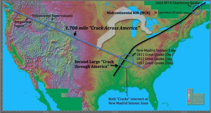
– Scientists Found a 1,700 Mile Crack Across the USA. Here’s What You Need to Know:
Is America at risk for Great earthquakes spanning across the full United States? “Cracks Across America”, in Rift zones, may conceal large fracture type faults where scientists may not be able to identify where these hidden fractures may unleash catastrophic earthquakes.
LOS ANGELES, CA (California Network) – In Nov 1981, a study was published that rocked the scientific world, and sparked concern in FEMA circles, in which a 1,700 mile “Crack Across America” was discovered. Worse yet, this crack cuts through the New Madrid Seismic Zone, where in 1811 and 1812 three giant earthquakes devastatingly struck the center of America. Scientists have been struggling, since then, to answer the question of what risk this mega feature may pose to our heartland today. Recently, and less known, is a study from an independent geologic research set of work [2], that has identified a possible second “Crack Through America” that crosses into and through the same volatile New Madrid Seismic Zone.
The original 1,700 mile “Crack Across America” was found using modern day gravity mapping satellite data, and using computers, to process the measurements [1]. In 1981, Dr. Raymond E. Arvidson of Washington University in St. Louis used data processing techniques where 600,000 discrete gravity measurements, from 20 years of scientific data gathering, to synthesize a map. The results revealed an astonishing ancient rift in the North American crust that extends some 1,700 miles from Idaho to the southern Appalachian Mountains. New discoveries, from more recent research, has extended this “Crack” anomaly in where it combines with a MegaShear [3] zone to the middle of Washington State and possibly with the Olympic-Wallowa Lineament (OWL) [2] – which reaches to the Pacific Ocean near Port Angeles Washington. Thus the total length may total nearly 2,200 miles.
This ancient rift, estimated to be a billion years old, was dubbed the “Missouri Gravity Low” in the eastern most section of the “Crack Across America”. Another rift, 60 miles by 30 miles, underlying the Mississippi river valley, called the “Reelfoot Rift”, was found to cross through the Missouri Gravity Low and head to the northeast/southwest. These two rift zones intersect at the New Madrid Seismic Zone. Over 4,000 small earthquakes have been mapped within these intersecting “rift” regions since 1974.
A maverick geologist, Jack Reed, performed a study in mapping the frequency and location of larger magnitude earthquakes trending along the northeast trending lineament of the “ReelFoot Rift”. The resulting data indicated another concerning revelation – that a possible second “Crack Through America” connects the Reelfoot Rift with the well known St. Lawrence rift zone in Canada. Just as the New Madrid Seismic zone revealed its active potential in its “rift zones”, a magnitude 7.9 earthquake, in 1663, struck near Charlevoix and revealed its power in the St. Lawrence rift zone.
Perhaps a partial clue to what may link to the existence and nature of the “Crack Across America” and the “Crack Through America” is the Midcontinential Rift (MCR) System. Research has identified that a movement direction of the MCR, from tremendous intraplate pressure, forced a southern expansion of this large rift, where the southern edge traversed directly towards the New Madrid Seismic Zone. The Midcontinental Rift thus forms a horseshoe that straddles and reaches, by its tips, at or near the two major “Crack” lineaments. Intraplate pressure could be intensified into these intersecting lineaments, including the resulting pressure(s) at the New Madrid Seismic Zone.
What can make these – 70-90 mile wide and thousands of miles long – low gravity crack lineament features so dangerous is their hidden fractures, buried in the earth’s crust below. These low gravity areas are called “Rift zones” where the continental crust tried to pull itself apart, but failed. The thinning of the crust enabled lighter density young rock to intrude, thus resulting in the lower gravity characteristics in the rift zones. Other recent studies have suggested that the thinning of the crust may occur from the delamination of heavier crustal rock “falling” down into the earth’s mantle. However, in the case of linear features of these long distance “lineament rift zones”, the case of random delamination from “falling” into the mantle would not be able to explain these highly organized structures.
What is known, is that these linear rift zones have exhibited the ability to unleash very large earthquakes. This has been aptly demonstrated by the three 1811-1812 New Madrid M7-M8 earthquakes and the large 1663 M7.9 Charlevoix Earthquake. Since the regularity of such earthquakes are measured in centuries, scientists are unable to identify if any section of these linear rift zones may be at risk of a sudden large earthquake.
The bigger the length and depth of a buried fracture and its subsequent pressure induced release, the greater the chances for this rupture to unleash a giant earthquake. Indeed, the three 1811 to 1812 M7-M8 earthquakes had rupture release areas comparable to any single biggest locked segment of the San Andreas CA fault region could do – except in the New Madrid quakes, it did it all in the same location with each huge quake spaced only a month apart. With thousands of miles of possible buried fractures within these lineaments, it’s possible that changes in intraplate pressure may be all that is necessary to activate a segment. Another unanswered question is if Yellowstone Supervolcano is susceptible or interactive with this lineament. Indeed, in 2002, geologists observed distant triggering of earthquake swarming at Yellowstone from the M7.9 Denali Alaska earthquake [4]. As the Denali earthquake was 2,000 miles distant, what would happen if a large earthquake within a rift zone lineament was much closer to Yellowstone? Certainly it would be useful to know if there were any susceptible buried fractures in the nearby lineament that traverses near Yellowstone Supervolcano.

However, scientists are placed at a disadvantage, in earthquake risk assessment, since any hidden fractures are buried deep in what is called the “Midcontinental Basement”. Without having any data to the size, length, and number of any hidden fractures, it renders any risk analysis “blind”. Only a paleogeologic assessment of past locations, patterns, frequency, and magnitude of earthquakes are scientists able to form a type of a risk assessment. Compounding any risk assessment is understanding the rupture process of these hidden fractures. Scientists refer to these as “Intraplate earthquakes” as the quake occurs within the interior of a tectonic plate. Pressure, within the buried fracture (i.e. “fault”), may instigate an earthquake. GPS, strain sensors, and even inSAR (interferometric Synthetic Aperature Radar) are of no use to proffering answers to these questions as these fractures are inaccessible since they are deep below – while the sediment or crust above hides any telltale sign of crustal creep or stress.

Because of risk assessment uncertainty, FEMA and other emergency agencies are left to estimating the risk to America’s infrastructure based on a worst case paleogeologic history (i.e. the maximum at any moment). Indeed, in 1999 (inverted 666) there is a difference of viewpoints, regarding cost tradeoffs of implementation and/or upgrades of rigorous seismic building codes, between the scientific community and the emergency management organizations. Complicating this situation is that earthquakes, that occur in the central or eastern United States, affect much larger areas than similar magnitudes in the western United States. The FEMA guide references that the 1906 M7.8 San Francisco CA earthquake was felt 350 miles away in the middle of Nevada. In contrast, the 1811 New Madrid Earthquake was reported to have rung church bells in Boston, Massachusetts, 1,000 miles away. Differences in the geologic makeup of the earth’s crust east and west of the Rocky Mountains are noted to be the cause of this stronger conduction of the earthquake’s P-waves and S-waves creating the distant shaking contrast.
As the rate of earthquakes have been increasing in the New Madrid Seismic Zone and in other parts of the Central United States, such as in Oklahoma, there are concerns that intraplate tectonic pressure may be driving these trends. Other areas, such as the Wabash Valley and East Tennessee Seismic zones also produce earthquakes on a regular basis. Quoting from the CUSEC – “Depending on earthquake magnitude and location, each of these zones could impact multiple states, causing major physical, social and economic disruption in a region that is home to more than forty million people.”… “On April 18, 2008, a magnitude 5.4 earthquake struck near Mt. Carmel, Illinois. This relatively minor earthquake was felt in 28 states and Canada and was responsible for an estimated $3 million in non-structural damages and damaged at least 240 structures in Illinois alone. The Mt. Carmel earthquake shows the widespread impact a larger earthquake might have on the region”
Scientists now believe the Eastern U.S. could have a major quake of its own, and events like the New Madrid Great quakes may happen again, but there is no way to guess where or when.
Fig4-Crack In America


spacer
Eclipses and Little-known Faults


- The shadow will be 70 miles in diameter.
- The eclipse is the first to be fully contained within the USA.
- The eclipse will divide the nation in two.
- The eclipse will trace the 1,700 mile “crack across America” fault.
- The eclipse will occur 33 days before a once-in-7,000 years Revelation 12 sign.
- It will happen 2,422 days or 346 weeks or 6.6 years from a second, criss-crossing eclipse.
- It happens on the last day of the year in the Hebrew calendar.
- It traces through a second large fault running Northeast from the New Madrid seismic zone.
- It will be 120 miles in diameter.
- It occurs 10 years after the first blood moon of the 2014-2015 tetrad.
spacer
Do You Know About The 3 Eclipses That Will Combine To Create A Giant “Aleph” Over America?
by Michael

I am about to share something with you that is truly remarkable. The paths of three eclipses will combine to form a giant “Aleph” over America, and hardly anyone knows about this. Of course the Aleph is the first letter in the Hebrew alphabet. The second letter in the Hebrew alphabet is Bet. Most people don’t realize this, but our word “alphabet” originally came from a combination of Aleph and Bet. But is the fact that a giant “Aleph” will soon be completed over the United States significant? I believe that it is, and I will explain why in this article.
In the 21st chapter of Luke, Jesus warned us that “there shall be signs in the sun, and in the moon, and in the stars” in the last days.
So we should be watching for such things.
In order for an eclipse to happen, both the sun and the moon must be involved. Previously, I have explained how the “Great American Eclipse” of 2017 would later combine with the “Great American Eclipse” of 2024 to create a giant “X” across America. The following is an excerpt from my book entitled “7 Year Apocalypse”…
Well, what would you say if I told you that an enormous “X” that is in the process of being marked across the United States will be completed in the year 2024?
I know that may sound very strange, but stick with me and you will soon understand what I am talking about.
On August 21st, 2017 the “Great American Eclipse” made headlines all over the world. It was the very first solar eclipse since 1918 that was able to be seen all the way from the west coast to the east coast. In the U.S., the path of the eclipse started in Oregon, it continued all the way across the continental United States, and it exited the country in South Carolina.
But what makes that eclipse unlike any other is the fact that it will combine with another historic eclipse in 2024 to form a giant “X” across America.
On April 8th, 2024 another “Great American Eclipse” will make headlines all over the planet. The path of that eclipse will cross over the states of Texas, Oklahoma, Arkansas, Missouri, Illinois, Kentucky, Tennessee, Michigan, Indiana, Ohio, Pennsylvania, New York, Vermont, New Hampshire and Maine. If you plot the paths of the 2017 eclipse and the 2024 eclipse on the same map, you will clearly see that they combine to form a massive “X” right over the heartland of the continental United States.
The map below shows roughly what that giant “X” will look like…

The precise intersection formed by the Great American Eclipse of 2017 and the Great American Eclipse of 2024 covers portions of the states of Kentucky, Illinois and Missouri.
If you closely examine this area on a map, you will see that it falls right in the middle of the New Madrid Fault Zone.
In several of my books I have discussed the fact that someday there will be an absolutely catastrophic earthquake along the New Madrid Fault Zone. It will be so massive that it will permanently alter the geography of the United States, and you won’t want to be anywhere around when that quake finally arrives.
But now we are discovering that there is even more to the story.
On October 14th, 2023 an annular solar eclipse will cross the United States from Oregon to Texas.
If you overlay the path of that annular solar eclipse on top of the paths of the Great American Eclipse of 2017 and the Great American Eclipse of 2024, you will see that those three eclipses actually combine to create a giant “Aleph” across America.
A tweet that was posted by Randy Sevy about this phenomenon has created quite a stir…
I just saw this and got the shivers. Look at that. Those are the 2017, 2023 and 2024 solar eclipses on the United States. That’s God’s signature. That’s an Aleph. 𐤀
The Aleph is the first letter of the Hebrew alphabet. The Aleph in Hebrew has a numerical value of one. The Aleph is also representative of God and the oneness of God. The One true God.
The Aleph is also made of three lines. Also the number of God; The Father, the Son, and the Holy Spirit. The number three biblically represents divine wholeness, completeness and perfection.
This Aleph 𐤀 is from the Paleo-Hebrew script, also Palaeo-Hebrew, Proto-Hebrew or Old Hebrew. The writing system found in ancient inscriptions of biblical Israel and Judah.
When you look at the map that Randy Sevy shared on Twitter, there is no doubt that it looks like an Aleph…
So what does all of this mean?
I am not entirely sure.
But let me share something else with you.
If you do a Google search for when the new moon in Jerusalem will be in October 2023, you will discover that it will be on October 14th.
And that is the day when the annular solar eclipse will cross our country from Oregon to Texas.
If you do a Google search for when the new moon in Jerusalem will be in April 2024, you will discover that it will be on April 8th.
And that is the day when the “Great American Eclipse” crosses America and completes the Aleph.
By the way, April 8th also happens to be the first day of the first month on the Hebrew calendar.
In other words, a brand new Biblical year begins on that date.
I find it hard to believe that this is just a coincidence.
I think that God is trying to tell us something.
Of course He has been trying to warn us in hundreds of different ways, but most people don’t want to listen.
The signs of the end times are literally being fulfilled all around us, but most of us refuse to see the truth.
I will continue to do my best to sound the alarm, and I want to thank you for helping me to do that.spacer

Here’s why experts are warning California about ‘The Big One’
The most significant seismic event in California’s history – an earthquake of 7.9 magnitude – occurred in 1857 and ruptured about 225 miles on the San Andreas Fault. That earthquake, dubbed the last “Big One,” killed two people and produced shaking that lasted between one and three minutes.
Since then, California has exploded in population and has been rattled by many major earthquakes, some far more deadly and similarly strong. But Californians have also grown familiar with the existential dread of another “Big One” looming.
Researchers have long warned there will be another massive earthquake in Southern California. They just don’t know when.
A recent study says warning signs continue to grow in 2026. The San Andreas and San Jacinto fault systems have reached the highest stress levels seen in the past 1,000 years, according to a study conducted at the University of Hawaiʻi at Mānoa.
The San Andreas fault runs throughout the state, passing through San Francisco and San Bernardino, while the San Jacinto fault is in Southern California and runs through Riverside, San Diego and Imperial Counties.

Unable to view our graphics? Click here to see them.
Why the San Andreas Fault is so risky
Faults rupture on the San Andreas Fault approximately every 150 years, according to UCLA professor Jonathan Stewart, who studies earthquake engineering.
But it’s been over 300 years since the last “large rupture” occurred south of the 1857 Fort Tejon earthquake, Stewart said. “As far we know it didn’t produce a large rupture since around 1690. To the present that’s a lot more than 150 years, so there’s a lot of build-up. That doesn’t mean it’s going to happen immediately, it just means there is more stress built-up.”
When the earthquake happens, it is likely to cause a lot of damage. One major concern is the state’s water systems.
“An earthquake like this would rupture most, if not all of the major aqueducts bringing water into Southern California,” Stewart said. “Most people will not be in a collapsed structure after this earthquake, but everybody’s going to be affected by water problems.”


Study highlights longstanding risk
To investigate the probability of an earthquake occurring, researchers built a physics-based simulation and fed it the earthquake history from the region. By doing so, they were able to estimate how much stress has built up along the southern San Andreas and San Jacinto fault systems.
The results suggest that catastrophe may be near.
“Right now, with stress at historically high levels across the region and more than 160 years elapsed since the last major rupture, the system is in a critically loaded state,” lead author Liliane Burkhard said.
Most importantly, the Cajon Pass, at the junction of the San Andreas and San Jacinto faults, could facilitate a joint rupture of the two faults. This scenario, according to the study, would probably be “significantly more damaging” than a single-fault event.

Earth’s tectonic plates and boundaries

How do the fault lines rupture?
The San Andreas and San Jacinto faults are strike-slip faults, which typically cause horizontal displacement. Both faults comprise the geologic boundary between the Pacific Plate and the North American Plate.
If a major earthquake occurs on the San Andreas fault, it is likely to produce surface rupture, which occurs when a fault breaks through to the surface. Most earthquakes, however, do not produce surface rupture, according to USGS.
In a major rupture, strong shaking could cause severe damage near the fault and in areas built on soft or water-saturated soils, which can amplify shaking. Rupture can directly offset roads, buildings, and other structures that span the fault trace.
Although the study helps explain the risk associated with the California fault lines, Burkhard emphasized that it shouldn’t serve as a forecast.
“This is not a prediction of when an earthquake will happen,” Burkhard said. “However, studies like this are important contributions to national and global earthquake hazard research in that we are using rigorous, quantitative science to better understand the risk facing millions of people.”
SPACER

EDGAR CAYCE PREDICTED FUTURE FLOODING OF THE WORLD BELOW ARE RENDITIONS OF WHAT HE SAW.FOR THE UNITED STATES. The U.S. Navy adopted his map. World Maps Library – Complete Resources: Edgar Cayce Maps North America
 |
 |
| Map Of The Future United Sates According To Edgar Cayce | Future map of North America by Gordon-Michael Scallion / Matrix Institute |
SPACER
SPACERUPDATE ADDED 9/11/24; UPDATE ADDED 9/13/24 This is not the first time I have visited this topic, but the gravity of the situation demands attention. I have no doubt in my mind that they plan on causing the earth to be flooded. They love to show the Map of the Prediction of what the USA … Click Here to Read More

spacer
Seismologists are warning about a new fault line activity – and some say it’s being downplayed
Something is shifting beneath our feet, and the scientific community is increasingly vocal about it. Across North America and beyond, seismologists have been raising alarms about fault systems that are showing new or elevated activity – systems that sit beneath densely populated cities, many of which were never designed to absorb a serious earthquake. The warnings are not coming from fringe voices. They are emerging from university research labs, federal geological surveys, and peer-reviewed journals.
What makes the current moment feel different is not one single dramatic discovery. It’s a convergence. Multiple fault systems, from the Pacific Coast to the Midwest to the Canadian Yukon, are drawing simultaneous scrutiny. New technologies are revealing faults that were hidden for centuries. And fresh research is beginning to suggest that existing hazard models – the very models used to write building codes and set insurance rates – may be underestimating what these faults are actually capable of.
The West Coast Fault Connection No One Saw Coming

New research suggests the Cascadia subduction zone and the San Andreas fault can “sync up,” triggering earthquakes within minutes or hours of each other – a rare synchronization that could dramatically increase the scale of a major West Coast disaster, meaning multiple regions could be hit at nearly the same time. The research, published in 2025 and receiving wide attention in early 2026, reframes what many experts previously thought was a manageable, if serious, risk. Chris Goldfinger, a marine geologist at Oregon State University and the study’s lead author, put it plainly: “We’re used to hearing the ‘Big One’ – Cascadia – being this catastrophic huge thing. It turns out it’s not the worst case scenario.” To investigate this possibility, Goldfinger and his colleagues examined sediment cores taken from the ocean floor, which preserve roughly 3,100 years of geological history. The team focused on turbidites – layers of sediment left behind by underwater landslides often triggered by earthquakes. By comparing turbidite layers from areas influenced by both fault systems, researchers identified similarities in their structure and timing, pointing to a potential synchronization between the two faults. It is, by any measure, one of the most significant recalibrations of Pacific Coast seismic risk in decades.
The Hayward Fault: An Overdue Threat Beneath Millions

The Hayward fault, part of the San Andreas fault system, runs 74 miles through the San Francisco Bay Area, and research shows the seismically active fault is well overdue for an earthquake. The past five major earthquakes on the Hayward fault have occurred roughly every 140 years on average, and we are now well beyond that interval since the fault’s last major event in 1868, according to the UC Berkeley Seismology Lab. That’s not a distant future concern – it’s a statistical reality that geologists have been quietly absorbing for years. The U.S. Geological Survey estimates a roughly one-in-seven chance of a magnitude 6.7 or larger event by 2034, and about one-in-three chance before 2043 – making the Hayward fault the most dangerous in the Bay Area. The cities on and immediately near the fault include Oakland, Berkeley, Hayward, Fremont, San Leandro, Richmond, El Cerrito, and Milpitas, putting millions at risk. Scientists studying this fault are not just monitoring it; they are actively modeling it, trying to understand what a modern rupture would mean for bridges, hospitals, and water infrastructure.
Southern California’s 1,000-Year Stress High

The ground beneath Southern California is holding a historic amount of strain. With the San Andreas and San Jacinto faults hitting a 1,000-year stress high, the Cajon Pass stands as the critical junction that will shape the region’s next major disaster.
This isn’t alarmist rhetoric – it reflects the accumulated geological pressure that builds when tectonic plates are locked in place for extended periods. The longer the interval between major releases, the more energy that remains stored in the crust.


A region of the infamous San Andreas Fault could produce an earthquake any day, scientists suspect. The San Andreas Fault, which forms the border between two enormous tectonic plates beneath Earth’s surface, stretches for more than 800 miles through California – and the plates are relatively static, meaning they can build up large pressures over time.
A paper published in Frontiers in Earth Science, by researchers from UC Berkeley, the U.S. Geological Survey, and Italy’s National Institute of Geophysics and Volcanology, focused on a section of the fault near Parkfield, California – a region that produces earthquakes in a rough pattern of every 22 years, more or less.
The Newly Awakened Fault in Canada’s Yukon

The Tintina fault in Canada’s Yukon Territory, once thought to be dormant for millions of years, has been showing signs of seismic activity – raising concerns among researchers about the potential for future earthquakes. This finding could have serious implications for the region’s infrastructure, including nearby highways and mining operations.
The fault stretches over 1,000 kilometers from the Yukon into Alaska. It’s a reminder that not all dangerous faults are in places people have been watching closely.
Researchers from the University of Victoria, the Geological Survey of Canada, and the University of Alberta used high-resolution topographic data from satellite images, as well as LIDAR surveys conducted by drones and aircraft – technology that gave scientists a clearer view of the landforms in the region, revealing offsets in the Earth’s surface that indicate seismic activity. Among the most significant discoveries was evidence of fault scarps, a feature caused by vertical shifts along a fault line.
Many geologists argue that remote, vegetation-covered terrain has long hidden seismic hazards that simply haven’t been mapped yet.
The Midwest’s Sleeping Giant: New Madrid

There is broad agreement in the scientific community that a continuing concern exists for a major destructive earthquake in the New Madrid seismic zone, with many structures in Memphis, Tennessee, St. Louis, Missouri, and other communities in the central Mississippi River Valley region being vulnerable and at risk from severe ground shaking. What’s particularly unsettling about New Madrid is the physics of the region. When earthquakes do occur in the Midwest, the destruction covers more than 20 times the area compared to a similar event in California, due to geologic differences between the two regions. Scientists estimate that the probability of a magnitude 6.0 or larger earthquake occurring in the New Madrid seismic zone within any 50-year period is somewhere between roughly one-quarter and two-fifths. Most structures in the region were not built to withstand earthquake shaking, as they have been in more seismically active areas like California – and earthquake preparations have lagged far behind. The combination of a scientifically credible risk and a deeply underprepared built environment is exactly what concerns scientists most.
spacer
spacer
Unknown Faults Keep Striking Without Warning

Even more concerning to researchers is the high rate of damaging earthquakes caused by unknown faults. In a span of only 13 years, scientists recorded at least four powerful earthquakes generated by previously unidentified active faults in the Philippines alone – including events in Negros Oriental in 2012, Bohol in 2013, Zambales in 2019, and northern Cebu in 2025.
The pattern reinforces a troubling truth: official fault maps are incomplete, sometimes dangerously so. There are many faults that have not been discovered because they are concealed by vegetation or young sediment, while others have not been found because detailed geologic studies necessary to locate them have simply not been completed.
There are also known faults that remain poorly understood. This is not a problem limited to developing nations.
In Washington State alone, each fault generally produces an earthquake infrequently – on the order of every 1,000 to 10,000 years – which can make it difficult to know how concerned communities should be about them.
SPACER
SPACER
What the Myanmar Earthquake Revealed About Risk Models

SPACERA rare, ultra-long earthquake in Myanmar in 2025 revealed that mature faults can deliver their full force directly to the surface – a discovery that could mean stronger shaking near faults like California’s San Andreas than current models predict. The implications go well beyond Myanmar. As lead researcher Eric Lindsey explained, “on mature, smooth faults, the energy is highly focused and comes right to the surface” – which means the ground shaking near the fault line might be more intense than current hazard models predict for these types of faults. Insurance catastrophe models may be underestimating earthquake losses because they fail to account for a class of seismic events linked to most insured earthquake losses over the past decade, according to new research from MS Amlin. The study found that so-called supershear earthquakes accounted for roughly two-thirds of insured earthquake losses since 2016 – equivalent to $13.2 billion – despite being absent from seismic hazard assessments, building design standards, and insurance catastrophe models. That gap between what the models assume and what nature actually does is precisely where the “downplayed” argument gains its strongest footing.
SPASCER
SPACER
Why Some Scientists Say the Risks Are Being Minimized

Scientists and their partners have revealed that nearly 75 percent of the United States could experience damaging earthquake shaking – a finding that emphasizes seismic hazards span a significant part of the country. Yet many of the communities sitting inside these hazard zones have little awareness of the threat and even less in the way of preparation.
The gap between what researchers know and what local governments act on has been a persistent frustration in the seismological community for years. The 2025 Myanmar earthquake ruptured 475 kilometers of fault – more than twice the length predicted by existing magnitude scaling relationships – and the anomalous length exposed a vast population to violent near-fault shaking.
Standard probabilistic seismic hazard analyses use scaling relations that do not account for such long ruptures at moderate magnitudes – a limitation that, in conjunction with increased population exposure, contributes to a potential mischaracterization of seismic risk. That word – mischaracterization – is doing a lot of work.
For the researchers who use it, it is a careful scientific way of saying that what is officially presented as acceptable risk may not, in fact, be acceptable at all.
What Comes Next

The honest answer is that no one can predict the next major earthquake. Predicting earthquakes with high precision remains an elusive goal for seismologists – while we cannot definitively say when a major earthquake will occur, we can analyze seismic activity, geological data, and statistical probabilities to identify potential risk zones.
The tools are improving. LIDAR scanning, ocean floor sediment cores, satellite-based deformation mapping, and machine learning are all giving researchers a far more detailed picture than was possible even a decade ago.
What is growing harder to accept, though, is the idea that this expanding knowledge is being matched with equal urgency on the policy side. When a 2026 study shows fault systems can synchronize across hundreds of miles of coastline, when hidden faults keep generating surprise earthquakes in populated areas, and when risk models are shown to miss categories of damage that account for billions in real-world losses, the conversation needs to go somewhere beyond the journal pages.
The science is telling a consistent story. The question is whether the people responsible for preparing cities and writing building codes are truly listening.

Earth “Opening Up” — What’s Happening Worldwide
Recent research shows that Earth is experiencing multiple large-scale “opening” processes in different regions, from tectonic plates tearing apart to continental rifts and massive sinkhole collapses.
1. Tectonic plates splitting beneath the Pacific Northwest
Scientists have, for the first time, directly observed a subduction zone in the act of breaking apart off the coast of Vancouver Island in the Cascadia region ScienceDaily+1. Here, the Juan de Fuca and Explorer plates are sliding beneath the North American plate, but seismic imaging shows they are tearing into fragments rather than sinking smoothly. This “train wreck” of a subduction zone is a rare, real-time view of how these powerful geological systems eventually fail, offering clues to earthquake risks and the lifecycle of tectonic plates.
2. The East African Rift — a continent splitting open
The East African Rift stretches 2,000 miles from the Red Sea to Mozambique and is actively pulling the Somali and Nubian plates apart Earth.com. Seismic models show the crust is thinning in some areas, with magma rising to push the land open. If the current rate continues, a new sea similar in size to the Red Sea could form in 20–30 million years, potentially evolving into a smaller Atlantic-like ocean. This rifting is driven by mantle plumes and volcanic activity, and it is the largest ongoing continental split on Earth.
3. Massive sinkhole collapses worldwide
In addition to plate-scale movements, giant sinkholes are opening across the globe, from China to Mexico to Turkey YouTube. These form when soluble rocks dissolve underground, creating vast voids that eventually collapse. Recent satellite data show some are expanding faster than expected, exposing ancient river systems, fossil records, and isolated ecosystems. These events reshape landscapes and raise questions about ground stability.
4. Urban gullies in Central Africa
In the Democratic Republic of the Congo, massive “urban gullies” are tearing through cities, displacing tens of thousands of people www.sciencenewstoday.org. These deep, wide chasms form when rainwater erodes sandy, sloped terrain, often worsened by poor drainage and unplanned urban growth. They can appear suddenly and swallow infrastructure and homes.
In summary:
- Pacific Northwest: Subduction zone breaking apart in real time.
- East Africa: Continental rifting toward a new ocean basin.
- Global: Sinkhole collapses exposing hidden underground worlds.
- Central Africa: Urban gullies destroying communities.
These processes are not the same event, but they all represent “Earth opening up” in different ways — from deep tectonic changes to surface collapses — and they are being studied to improve hazard prediction and understand planetary evolution.
spacer
Don’t let yourself be fooled by their lies. They are studying these events for the same reason they have been mapping everything, so that they can gain full control of everything. They cause these events and then they study the fallout. How the environment responds, how people respond, how governments respond.
SPACER

2.34M subscribers
spacer

60.9K subscribers
 • Science News & Documentaries Discover the fascinating world of science, current science news and exciting space documentaries in this ultimate playlist! Stay up to date on the latest discoveries in physics, astronomy, biology and technology, as well as groundbreaking research results. Explore the secrets of the universe, black holes, exoplanets and future space missions with high-quality documentaries and analysis. Whether you are interested in astrophysics, quantum mechanics or the latest scientific breakthroughs, you will find a wealth of knowledge and fascinating insights here. Subscribe now and immerse yourself in the world of science! #Science #Space #ScienceNews #Documentary #Science, #Space, #Astronomy, #Universe, #Space travel, #Research, #Physics, #Technology, #spacenews
 spacer

687K subscribers
From tectonic rifts to erosion gullies and groundwater-induced fissures, massive cracks are appearing across the globe, with serious environmental and human impacts.
1. Tectonic Rifts — Africa’s East African Rift
A major example is the East African Rift, a 1,860‑mile (3,000 km) zone where the Somali and Nubian tectonic plates are pulling apart Africa Times.
Kenya’s large crack in 2025 highlighted the rift’s instability, with parts of highways collapsing Africa Times.
Scientists say the Turkana Rift in Kenya and Ethiopia is in a “late‑stage” rifting phase, with crust thinning and “necking” that could eventually split the continent and form a new ocean abcnews.com.
This is a natural geological process driven by mantle plumes and plate motion, but it poses seismic and volcanic hazards.
2. Urban Gullies — Central Africa’s Hidden Hazard
In the Democratic Republic of the Congo (DRC), new research mapped 2,922 massive erosion channels across 26 cities www.sciencenewstoday.org+1.
These “urban gullies” can stretch hundreds of meters, swallow roads, and displace tens of thousands of people www.sciencenewstoday.org.
Between 2004 and 2023, they displaced nearly 118,600 people; by 2023, 3.2 million lived near active channels www.sciencenewstoday.org+1.
Causes: sandy soils, steep slopes, poor drainage, and rapid urban growth without infrastructure. Heavy rains turn runoff into destructive streams.
3. Groundwater‑Induced Fissures — Southwestern US
In Arizona, Utah, and California, large fissures are forming due to over‑pumping of aquifers WION.
Removing too much groundwater causes the land to sag and crack — these are not natural but human‑caused WION.
Over 169 miles of fissures are mapped in Arizona alone; they threaten homes, roads, and infrastructure.
The problem is linked to unsustainable water use, with aquifers potentially taking centuries to recover.
4. Why These Cracks Matter
Tectonic rifts shape continents over millions of years but can cause earthquakes, volcanic eruptions, and land subsidence.
Urban gullies destroy infrastructure, displace communities, and worsen with climate change and urban expansion.
Groundwater fissures threaten water security, infrastructure, and property values.
In short: “Huge cracks” worldwide range from natural geological rifts to human‑driven land failures. They can be slow‑forming or sudden, and all carry significant risks to people, economies, and the environment. Monitoring, sustainable land/water use, and urban planning are key to reducing their impact.
spacer
This is the game they are playing on your mind. Give up your rights for safety. They will not only monitor all water usage, they ration it, police it and punish anyone who does not follow orders. They will also TAX it. You can believe it or not, but they also plan to TAX sunshine and the air you breathe.
spacer
Scientists confirm that giant Earth cracks are devouring entire cities
New satellite maps show fast-growing erosion channels across the DRC, exposing over 3.2 million people to a hidden urban hazard.

Across the Democratic Republic of the Congo, fast-growing ground fractures are quietly reshaping cities. New research shows that more than 3.2 million people now live next to these expanding erosion channels.
These erosion channels are features that can deepen, widen, and carve through entire neighborhoods in just a few rainy seasons.
The mapping effort, led by Matthias Vanmaercke, a geographer at KU Leuven, along with Congolese partners, reveals a hazard that grows alongside urban expansion.
Dozens of rapidly developing cities are affected, and the new dataset offers the clearest picture yet of just how far these fractures reach – and how quickly they advance.
Mapping the erosion channels
These fissures are urban gullies, erosion channels that begin when stormwater cuts into loose soil and continues deepening. They can slice through neighborhoods and sever roads within a few rainy seasons.
Researchers mapped 2,922 distinct features across 26 Congolese cities using recent satellite images paired with historical aerial photos.
Together, those channels stretch about 459 miles, a length comparable to the distance from New York City to Pittsburgh.
In Kinshasa alone, hundreds of separate channels carve through densely built districts, forcing emergency repairs and detours.
The dataset shows a hazard that is not a one-off event but a persistent urban process that expands with each intense storm.
Cities fuel erosion channel growth
When rain hits roofs and pavement, it becomes runoff, rainwater that flows over hard surfaces rather than soaking into the ground.
That flow races downhill, gathers in streets, and scours exposed soils where drainage is missing or clogged.
Roads matter because they collect and redirect water into narrow paths that act like flumes. Most mapped channels physically connect to the road network, so poorly drained streets can turn from infrastructure into engines of erosion during downpours.
Vegetation removal leaves bare, sandy hillsides that slough away under concentrated flow. Added impermeable surfaces, such as asphalt and concrete that block infiltration, increase the volume and speed of water that reaches vulnerable slopes.
These features differ from sinkholes, sudden collapses caused by underground voids in soluble rock. Urban gullies lengthen and widen over years, so the footprint expands even when the head of the channel appears quiet.
Risk hotspots mapped
By 2023, about 2.7 million residents lived within 328 feet of an active channel, a distance where property damage and access problems are common.
Another half million people occupied zones the authors expect to erode within a decade if nothing changes.
The exposed population roughly doubled between 2010 and 2023 as cities grew outward and upward. New construction clustered near existing hazard zones, which means today’s planning choices will lock in tomorrow’s risk.
Risk concentrates on steep, sandy plateaus and hillslopes that ring many Congolese cities. In those places, rainfall intensity and fragile soils combine with rapid development, producing the recipe for fast-carving channels after each storm.
Household vulnerability multiplies the danger because many affected neighborhoods lack formal drainage, land titles, or resources to relocate.
The result is a creeping disaster that erodes savings, trust, and infrastructure even before a wall or road collapses.
Erosion channel impact grows rapidly
From 2004 to 2023, an estimated 118,600 people lost homes as erosion channels widened or advanced into blocks that had seemed stable a few years earlier.
Since 2020, the annual displacement rate has averaged about 12,200 residents, a jump that mirrors recent surges in urban growth.
Nearly all mapped features expanded at least once in the observation window, confirming that the threat is dynamic, not static.
Most displacement stems from sidewall widening, the slow outward collapse of steep gully banks, which accounts for roughly two-thirds of uprooted households.
“It’s an underestimated and severely under-researched hazard,” said Vanmaercke. His remark captures a pattern that keeps recurring when cities outpace the infrastructure meant to guide water safely to rivers.
Looking ahead, the authors note that tropical Africa is projected to see heavier downpours in coming decades. More intense rainfall, stacked on rapid urbanization, means the same streets that move people today could channel destructive flows tomorrow.
What smarter city planning can do
Stopping channels early costs less than rebuilding after neighborhoods collapse. Stabilizing a single mature gully can exceed $1 million, a price tag that makes prevention the only workable strategy at city scale.
The first priority is to capture water before it concentrates, using upslope cisterns, terraces, and graded inlets that flow into protected drains.
Well-placed culverts, pipes that carry stormwater under roads, help prevent streets from turning into fast-moving streams.
Where channels already exist, a mix of engineered works and living cover is needed. Vegetation alone rarely holds when banks are tall, but deep-rooted plantings can lock in soil around gabions, retaining walls, or lined channels.
Urban risk plans should explicitly include disaster risk reduction, the planning that cuts deaths and losses through targeted investments.
That means mapping expansion zones, enforcing setbacks, and aligning zoning with hydrology so new streets do not pour water into the next failure.
Lessons from the erosion channels
At its core, this is physics meeting city building. Concentrated water has more power than soil can resist, so it carves a path, picks up more water, and carves deeper.
Cities can break that feedback loop by spreading water out and slowing it down before it gathers force. The science is clear, and the maps show exactly where the next cut could begin.
Local context matters, because a solution that works on one sandy plateau may fail on a clay hillside. Even so, simple actions like maintaining drains and keeping vegetation buffers around streams pay off almost everywhere.
The data give leaders a chance to act before the next rainy season. Early choices about drainage, materials, and road layout will decide whether homes stand or fall when the clouds open.
spacer
Mount St. Helens Is Shaking While It Sinks – YouTube 


Earth Tearing: What world is opening under us? – YouTube
-
Author: Explore Geograph
Cracks in the ocean floor are dynamic geological features formed by tectonic plate movements, including mid-ocean ridges, rift valleys, and internal plate faults, constantly reshaping the seafloor.
What Are Ocean Floor Cracks?
The ocean floor is far from static; it is a dynamic landscape shaped by tectonic forces. The most prominent cracks are found along mid-ocean ridges, which are underwater mountain ranges where tectonic plates diverge. These ridges feature central rift valleys, deep linear depressions where the actual separation of plates occurs, and are sites of volcanic activity where magma rises to form new oceanic crust mikegravel.org. Hydrothermal vents along these cracks release mineral-rich fluids, supporting unique ecosystems mikegravel.org.
Causes of Cracks
Cracks form primarily due to tectonic plate movements. Plates can diverge, converge, or slide past each other, creating fractures in the crust. In some cases, internal stresses within a plate, such as those observed in the Pacific Plate, can generate massive faults and tears thousands of meters deep and hundreds of kilometers long, showing that even oceanic plates are not monolithic geologyin.com+1. These internal cracks can influence how plates move and deform over time.
Rapid Seafloor Spreading
Recent research shows that seafloor spreading is not always slow and continuous. Along fast-spreading ridges like the East Pacific Rise, the crust can fracture rapidly during episodic magmatic intrusions, reshaping ocean basins faster than previously thought Indiatimes.com. In contrast, slower ridges like the Mid-Atlantic Ridge spread at only a few centimeters per year, but still form extensive cracks and new crust over geological timescales Indiatimes.com.
Examples of Cracks
- Mid-Atlantic Ridge: A slow-spreading ridge forming a continuous underwater mountain chain with central rift valleys Indiatimes.com.
- East Pacific Rise: A fast-spreading ridge with rapid episodic cracking and magma intrusions Indiatimes.com.
- Cascadia Subduction Zone: Observed deep fractures and vertical offsets where sections of the oceanic crust are detaching beneath the North American Plate dailygalaxy.com.
- East African Rift (on land): A continental example where a 35-mile fissure opened in Ethiopia, eventually forming a new ocean earthlymission.com.
Implications
These cracks are crucial for understanding plate tectonics, earthquakes, and volcanism. They also create new oceanic crust, influence ocean basin evolution, and host unique ecosystems around hydrothermal vents mikegravel.org. Studying these features helps scientists predict geological hazards and understand Earth’s dynamic interior.
In summary, cracks in the ocean floor are active, evolving features caused by plate divergence, internal stresses, and magmatic activity, ranging from slow-spreading rifts to rapidly fracturing fast-spreading ridges, and they play a central role in shaping the planet’s surface and oceanic ecosystems geologyin.com+3.
spacer

66.9K subscribers
Sinkholes in the USA in 2026
There is no official national total for U.S. sinkholes in 2026, but verified incidents include at least one major case in January in San Diego, with more scattered reports statewide trendsmask.com.
Current situation in 2026
The U.S. Geological Survey (USGS) confirms there is no national database of sinkhole collapses, and many events are never reported trendsmask.com. This means:
- Exact 2026 total: unavailable.
- Verified incidents: only scattered local reports so far, such as a January 15, 2026 sinkhole in San Diego caused by a water main break trendsmask.com.
- Best approach: compile state-by-state incident reports and media coverage, then remove duplicates to get a more complete picture trendsmask.com.
High‑risk states
According to 2026 risk mapping data, Florida, Kentucky, Pennsylvania, and Alabama consistently show the highest sinkhole activity due to soluble bedrock like limestone blogics.co.uk. Other states with karst geology (e.g., Missouri, Tennessee) also have notable risks Interactive Sinkhole Maps.
How to check sinkhole risk
- State geological survey websites and the USGS offer free interactive sinkhole risk maps blogics.co.uk.
- These maps show color‑coded risk zones (red = high, green = low) and historical sinkhole locations blogics.co.uk.
- You can search by address, ZIP code, or coordinates to assess local hazard levels Interactive Sinkhole Maps.
Resources for 2026
- SinkholeMaps.com aggregates data from multiple state agencies for interactive searches in FL, KY, PA, MO, TN Interactive Sinkhole Maps.
- USGS hazard maps and state surveys provide official geological hazard assessments blogics.co.uk.
- 2026 Sinkhole Conference in Albany, NY (Oct 5–9) will feature the latest research on karst geology and mitigation www.sinkholeconference.com.
Practical takeaway
For 2026:
- No precise national count exists; rely on local/state reports.
- Use official risk maps to assess your area’s vulnerability.
- Monitor state geological surveys and local news for new incidents.
- If in a high‑risk zone, consider property insurance and groundwater management practices to reduce risk.
If you need a state‑specific sinkhole report, check your state’s geological survey site or the USGS hazard map tools for the most accurate, up‑to‑date data trendsmask.com+1.

Sinkhole Maps, Information, and News | Interactive Sinkhole Maps
Are you buying a house in a sinkhole-prone area? Use our interactive sinkhole maps to avoid purchasing a sinkhole house!

SPACER
Sinkholes Opening Worldwide — Recent Events and Causes
Massive sinkholes are now being reported across multiple continents, from China’s Guangxi “heavenly pits” to urban collapses in Bangkok, Mexico City, and Japan, often linked to underground erosion, infrastructure failure, and extreme weather www.splashtravels.com+1.
Recent Global Incidents
- China (Guangxi) — In May 2022, explorers entered the Leye Tiankeng, a 630‑ft‑deep, 1,000‑ft‑wide karst sinkhole revealing a hidden prehistoric forest. Guangxi is home to over 90 of the world’s ~300 known “tiankeng” (heavenly pits) www.splashtravels.com.
- Bangkok, Thailand — On Sept. 24, 2025, a 50 m (164 ft) deep sinkhole opened near Vajira Hospital, swallowing vehicles and damaging utilities The Watchers.
- Mexico City, Mexico — A soda delivery truck collapsed into a sinkhole in Iztapalapa borough after drainage system failure The Watchers.
- Japan (Saitama Prefecture) — A sinkhole in Yashio swallowed a truck and trapped its driver; a second nearby opening nearly doubled its size The Watchers.
- Brazil (Buriticupu) — Over 1,200 residents face threats from expanding sinkholes due to erosion; a state of emergency was declared The Watchers.
- UK (Shropshire) — A canal bank collapse created a large sinkhole, pulling narrowboats into the cavity The Watchers.
- Malibu, USA — A sinkhole collapsed a driveway at Nicolas Cage’s beachfront home, prompting evacuations The Watchers.
Causes
Sinkholes form when the ground above collapses into underground voids. Common triggers include YouTube+1:
- Karst terrain erosion — Rainwater dissolves limestone, creating caves and voids.
- Groundwater loss — Over‑pumping or drainage failures remove support.
- Mining or construction — Underground voids left by excavation.
- Extreme weather — Heavy rain or flooding weakens soil and rock.
- Aging infrastructure — Damaged pipes, canals, or foundations.
Why They’re Increasing
Population growth, water scarcity, and climate change are intensifying conditions that weaken the ground YouTube. In karst regions like Guangxi, natural erosion still produces dramatic sinkholes, but human activity and weather extremes are making them more frequent and hazardous in urban and rural areas alike.
In short: Sinkholes are now a global concern, with both natural geological wonders and dangerous urban hazards being reported worldwide. Monitoring, infrastructure upgrades, and climate resilience measures are key to reducing risks.
Giant Sinkholes Are Suddenly Appearing Worldwide – What’s Wrong?
From swallowed streets to gaping craters, these photos capture some of the most dramatic sinkholes that have opened up around the world in recent years.
Published: