
COVERAGE OF THE LA PALMA CONTINUES ON THE FOLLOWING POST: UPDATED ALERT FOR POSSIBLE EAST COAST TSUNAMI CONT’D 6
UPDATE: 11/16/2021; 11:38:26 AM– STAY ALERT – DAY 58 STILL VERY ACTIVE 4.4 Earthquake this morning.
ASH Tornadoes
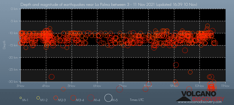
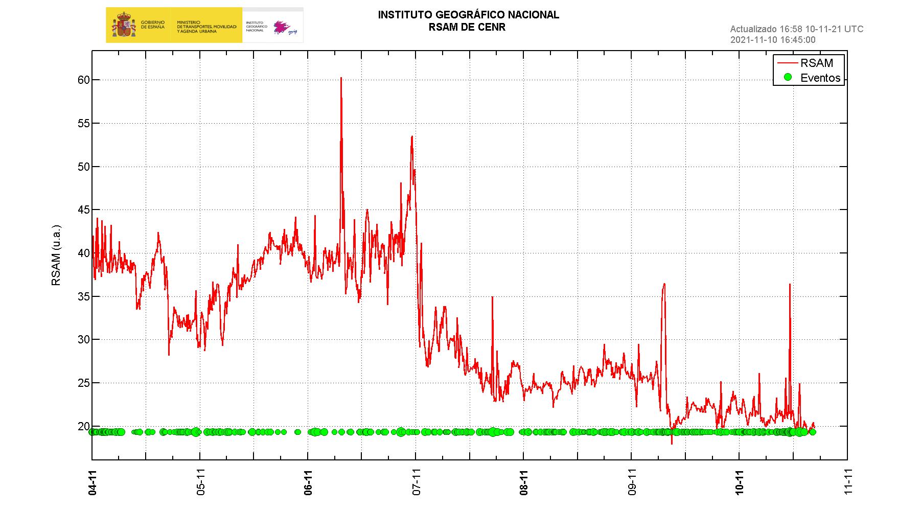
Earthquakes
Things are about to get much worse for the residents of La Palma
THIS VOLCANO IS NOT DYING!!
KEEP WATCH – This Volcanic Activity is FAR FROM OVER! Stay Vigilant. There is still a VERY REAL Possibility of the MEGA TSUNAMI occurring. Keep checking this update. I will be watching the situation until it is truly OVER.
Ok, Folks, this could be crucial not only for those living in the Eastern portion of our Nation, but for all of us. If this thing occurs the way they are predicting, it will devastate our entire nation. Millions of lives will be lost. The rest of us will be affected you can count on it.
If and/when I receive any updates I will add them to this post or create a new one and link it.
I do want to tell you that I had receive notification that the La Palma Alert had been updated to ORANGE or LEVEL However, the postings related to that have been removed from all outlets. I don’t know why or what that means. I will continue to search for updates and documentation of the Alert Status. Which I will post here.
Be PREPARED not Scared!! Have FAITH IN GOD. Keep Looking UP!! OUR REDEMPTION DRAWETH NIGH!
Ok, Folks, this could be crucial not only for those living in the Eastern portion of our Nation, but for all of us. If this thing occurs the way they are predicting, it will devastate our entire nation. Millions of lives will be lost. The rest of us will be affected you can count on it.
If and/when I receive any updates I will add them to this post or create a new one and link it.
Be PREPARED not Scared!! Have FAITH IN GOD. Keep Looking UP!! OUR REDEMPTION DRAWETH NIGH!
Here are the links for all the parts of this coverage of the La Palma Event:
Millions Could Be Washed Away (original post)
-
Cumbre Viejo Volcano Could Mean Disaster for the US EAST COAST
-
UPDATED ALERT FOR POSSIBLE EAST COAST TSUNAMI
-
UPDATED ALERT FOR POSSIBLE EAST COAST TSUNAMI CONTINUED
-
UPDATED ALERT FOR POSSIBLE EAST COAST TSUNAMI CONT’D 2
-
UPDATED ALERT FOR POSSIBLE EAST COAST TSUNAMI CONT’D 3
-
UPDATED ALERT FOR POSSIBLE EAST COAST TSUNAMI CONT’D 4
-
UPDATED ALERT FOR POSSIBLE EAST COAST TSUNAMI CONT’D 5
RESCOURCES FOR INFORMATION ON THE CURRENT SITUATION:
LIVE CAMERAS:
![]() https://kimedia.es/es/play/
https://kimedia.es/es/play/
spacer


 #erupcionlapalmaa3n


SPACER
UPDATE: 11/16/2021; 11:38:26 AM
spacer
![]()
spacer
#LaPalma #Volcano 16 Nov 2021
Still very active since 19th September 2021 #Nature pic.twitter.com/s1bZC8OA1h— Spot On Locations (@SpotOnLocations) November 16, 2021
spacer
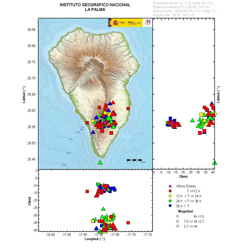
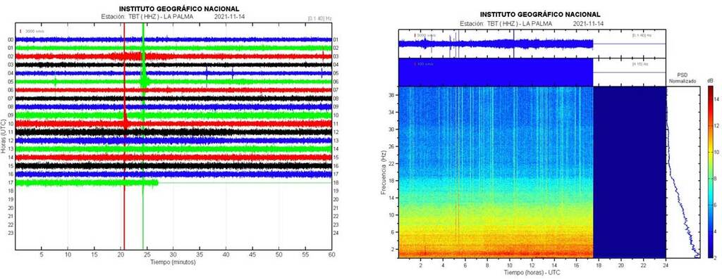
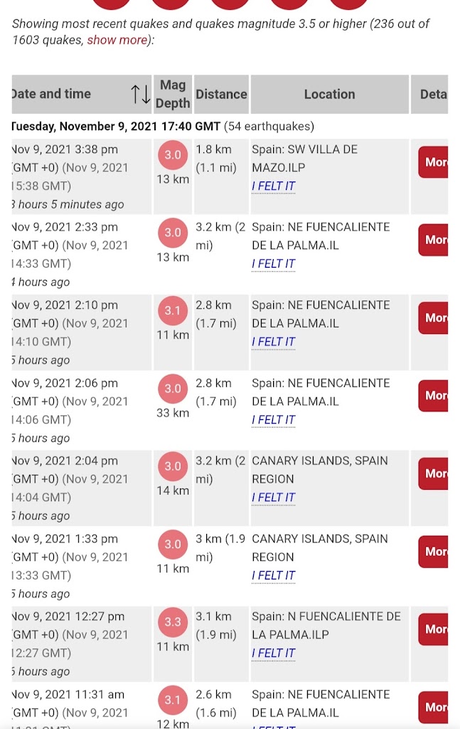
Once again they downgrade the 4.4. Also, look at the group of three highlighted in green. So close together not only in timing but in location.
Date and time |
Mag Depth |
Location | Details | Map |
| Tuesday, November 16, 2021 17:05 GMT (26 earthquakes) | ||||
| Nov 16, 2021 5:05 pm (GMT +0) (Nov 16, 2021 17:05 GMT) 19 minutes ago |
2.6
10 km |
La Palma Island, 13 km southeast of Los Llanos de Aridane, Spain | More | Map |
| Nov 16, 2021 4:57 pm (GMT +0) (Nov 16, 2021 16:57 GMT) 27 minutes ago |
2.6
10 km |
La Palma Island, 14 km southeast of Los Llanos de Aridane, Spain | More | Map |
| Nov 16, 2021 3:48 pm (GMT +0) (Nov 16, 2021 15:48 GMT) 1 hour 35 minutes ago |
3.1
10 km |
La Palma Island, 12 km southeast of Los Llanos de Aridane, Spain I FELT IT |
More | Map |
| Nov 16, 2021 2:59 pm (GMT +0) (Nov 16, 2021 14:59 GMT) 2 hours 24 minutes ago |
2.5
12 km |
La Palma Island, 14 km southeast of Los Llanos de Aridane, Spain | More | Map |
| Nov 16, 2021 2:29 pm (GMT +0) (Nov 16, 2021 14:29 GMT) 2 hours 55 minutes ago |
2.8
34 km |
La Palma Island, 12 km southeast of Los Llanos de Aridane, Spain | More | Map |
| Nov 16, 2021 2:07 pm (GMT +0) (Nov 16, 2021 14:07 GMT) 3 hours 16 minutes ago |
2.9
38 km |
La Palma Island, 14 km southeast of Los Llanos de Aridane, Spain | More | Map |
| Nov 16, 2021 1:27 pm (GMT +0) (Nov 16, 2021 13:27 GMT) 3 hours 57 minutes ago |
4.2
36 km 16 Nov 13:33: Magnitude recalculated from 4.4 to 3.8. Hypocenter depth recalculated from 40.0 to 5.0 km (from 25 to 3.1 mi). Epicenter location corrected by 34 km (21 mi) towards SE. |
La Palma Island, 14 km southeast of Los Llanos de Aridane, Spain I FELT IT – 12 reports |
More | Map |
| Nov 16, 2021 12:32 pm (GMT +0) (Nov 16, 2021 12:32 GMT) 5 hours ago |
3.3
34 km |
La Palma Island, 14 km southeast of Los Llanos de Aridane, Spain I FELT IT |
More | Map |
| Nov 16, 2021 12:16 pm (GMT +0) (Nov 16, 2021 12:16 GMT) 5 hours ago |
2.7
9.7 km |
La Palma Island, 13 km southeast of Los Llanos de Aridane, Spain I FELT IT |
More | Map |
| Nov 16, 2021 11:27 am (GMT +0) (Nov 16, 2021 11:27 GMT) 6 hours ago |
2.9
26 km |
La Palma Island, 17 km southeast of Los Llanos de Aridane, Spain | More | Map |
| Nov 16, 2021 10:40 am (GMT +0) (Nov 16, 2021 10:40 GMT) 7 hours ago |
2.4
11 km |
La Palma Island, 10.9 km southeast of Los Llanos de Aridane, Spain | More | Map |
| Nov 16, 2021 10:37 am (GMT +0) (Nov 16, 2021 10:37 GMT) 7 hours ago |
2.4
10 km |
La Palma Island, 12 km southeast of Los Llanos de Aridane, Spain | More | Map |
| Nov 16, 2021 10:36 am (GMT +0) (Nov 16, 2021 10:36 GMT) 7 hours ago |
2.5
10.4 km |
La Palma Island, 13 km southeast of Los Llanos de Aridane, Spain | More | Map |
spacer
![]()
spacer
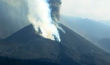
Day 58: Sunrise at the La Palma Volcano, Canary Islands
spacer
![]()
spacer
UPDATE: 11/16/2021; 6:18:40 AM
spacer
![]()
Premiered 38 minutes ago; 11/16/2021; 5:30 AM US CENTRAL TIME
spacer
UPDATE: 11/16/2021; 4:38:15 AM
spacer
![]()
Started streaming 3 hours ago; 11/16/21; 2:20 AM US CENTRAL TIME

spacer
|
@lacronicaverde
·
Yesterday I spent the night with the cocoon of the La Palma volcano. Experts say that it is losing strength. I wish. The terrifying blaze of its night glow spewing lava nonstop is something I will never forget #lapalma
|

spacer
 Lightning strikes in the VOLCANO of La Palma
spacer
![]()
Nov 16, 2021
spacer
NOTICE HOW MANY OF THESE EARTHQUAKES ARE COMING ONLY MINUTES APART! Some occurring at the same moment. I had seen that happen last night. But they erased the two I saw at that time. So, I went back to look. I had to pull some from the IGN because they were not on the Volcano Discovery list.
spacer
| Tuesday, November 16, 2021 06:34 GMT (11 earthquakes) | ||||
| Nov 16, 2021 10:03 am (GMT +0) (Nov 16, 2021 10:03 GMT) 8 minutes ago |
2.6
14 km |
La Palma Island, 13 km southeast of Los Llanos de Aridane, Spain | More | Map |
| Nov 16, 2021 7:51 am (GMT +0) (Nov 16, 2021 07:51 GMT) 2 hours 20 minutes ago |
3.2
34 km |
La Palma Island, 14 km southeast of Los Llanos de Aridane, Spain I FELT IT – 1 report |
More | Map |
| Nov 16, 2021 6:08 am (GMT +0) (Nov 16, 2021 06:08 GMT) 1 hour 15 minutes ago |
2.5
16 km |
La Palma Island, 13 km southeast of Los Llanos de Aridane, Spain | More | Map |
| Nov 16, 2021 6:06 am (GMT +0) (Nov 16, 2021 06:06 GMT) 1 hour 18 minutes ago |
2.5
11 km |
La Palma Island, 14 km southeast of Los Llanos de Aridane, Spain | More | Map |
| Nov 16, 2021 4:30 am (GMT +0) (Nov 16, 2021 04:30 GMT) 2 hours 53 minutes ago |
3.0
34 km |
La Palma Island, 14 km southeast of Los Llanos de Aridane, Spain I FELT IT – 1 report |
More | Map |
| Nov 16, 2021 2:41 am (GMT +0) (Nov 16, 2021 02:41 GMT) 5 hours ago |
3.3
12 km |
La Palma Island, 14 km southeast of Los Llanos de Aridane, Spain I FELT IT |
More | Map |
| Nov 16, 2021 2:00 am (GMT +0) (Nov 16, 2021 02:00 GMT) 5 hours ago |
2.9
14 km |
La Palma Island, 13 km southeast of Los Llanos de Aridane, Spain | More | Map |
| Nov 16, 2021 1:37 am (GMT +0) (Nov 16, 2021 01:37 GMT) 6 hours ago |
2.9
11 km |
La Palma Island, 13 km southeast of Los Llanos de Aridane, Spain 1 report | More | Map |
| Nov 16, 2021 1:26 am (GMT +0) (Nov 16, 2021 01:26 GMT) 6 hours ago |
2.5
10 km |
La Palma Island, 12 km southeast of Los Llanos de Aridane, Spain | More | Map |
| Nov 16, 2021 1:23 am (GMT +0) (Nov 16, 2021 01:23 GMT) 6 hours ago |
2.5
33 km |
La Palma Island, 9.4 km south of Santa Cruz de La Palma, Spain | More | Map |
| Nov 16, 2021 1:01 am (GMT +0) (Nov 16, 2021 01:01 GMT) 6 hours ago |
3.5
5 km |
29 km southeast of Santa Cruz de La Palma, Spain I FELT IT |
More | Map |
| Nov 16, 2021 12:02 am (GMT +0) (Nov 16, 2021 00:02 GMT) 7 hours ago |
2.7
33 km |
La Palma Island, 14 km southeast of Los Llanos de Aridane, Spain | More | Map |
| Monday, November 15, 2021 23:49 GMT (22 earthquakes) | ||||
| 3.3 mbLg | N FUENCALIENTE DE LA PALMA.ILP
2021/11/15 22:56:55
|
35 | + info | |
|
2.7 mbLg |
NE FUENCALIENTE DE LA PALMA.IL
2021/11/15 22:50:11
|
14 | + info | Map |
| 3.4 mbLg | W VILLA DE MAZO.ILP
2021/11/15 16:16:12
|
39 | + info | |
| 3.2 mbLg | NE FUENCALIENTE DE LA PALMA.IL
2021/11/15 16:12:21
|
27 | + info | Map |
|
2.4 mbLg |
SW VILLA DE MAZO.ILP
2021/11/15 14:13:23
|
14 | + info | |
|
3.0 mbLg |
NE FUENCALIENTE DE LA PALMA.IL
2021/11/15 14:10:39
|
14 | + info | Map |
| Nov 15, 2021 10:50 pm (GMT +0) (Nov 15, 2021 22:50 GMT) 9 hours ago |
2.7
14 km |
La Palma Island, 13 km southeast of Los Llanos de Aridane, Spain | More | Map |
| Nov 15, 2021 10:18 pm (GMT +0) (Nov 15, 2021 22:18 GMT) 9 hours ago |
2.6
35 km |
La Palma Island, 14 km southeast of Los Llanos de Aridane, Spain | More | Map |
| Nov 15, 2021 9:53 pm (GMT +0) (Nov 15, 2021 21:53 GMT) 10 hours ago |
2.6
29 km |
La Palma Island, 10.1 km south of Santa Cruz de La Palma, Spain | More | Map |
| Nov 15, 2021 9:11 pm (GMT +0) (Nov 15, 2021 21:11 GMT) 10 hours ago |
2.4
31 km |
La Palma Island, 13 km southeast of Los Llanos de Aridane, Spain | More | Map |
| Nov 15, 2021 8:58 pm (GMT +0) (Nov 15, 2021 20:58 GMT) 10 hours ago |
2.4
13 km |
La Palma Island, 14 km southeast of Los Llanos de Aridane, Spain | More | Map |
| Nov 15, 2021 7:34 pm (GMT +0) (Nov 15, 2021 19:34 GMT) 12 hours ago |
2.7
39 km |
La Palma Island, 12 km southeast of Los Llanos de Aridane, Spain | More | Map |
|
2.7 mbLg |
BE THE STEP.ILP
2021/11/15 06:15:47
|
37 | + info | |
|
2.5 mbLg |
NE FUENCALIENTE DE LA PALMA.IL
2021/11/15 06:13:16
|
16 | + info | Map |
|
2.9 mbLg |
NE FUENCALIENTE DE LA PALMA.IL
2021/11/15 04:34:07
|
fifteen | + info | |
|
2.5 mbLg |
SW VILLA DE MAZO.ILP
2021/11/15 04:31:55
|
12 | + info | Map |
| Nov 15, 2021 4:16 pm (GMT +0) (Nov 15, 2021 16:16 GMT) 4 minutes ago |
3.0
1 km |
30 km southeast of Santa Cruz de La Palma, Spain I FELT IT |
More Epicenter latitude / longitude: 28.44°N / 17.63°W↗ |
Map |
| Nov 15, 2021 4:16 pm (GMT +0) (Nov 15, 2021 16:16 GMT) 4 minutes ago |
3.0
1 km 16:32: Magnitude recalculated from 3.0 to 3.4 Hypocenter depth recalculated from 1.0 to 40.0 km (from 0.6 to 25 mi). |
30 km southeast of Santa Cruz de La Palma, Spain I FELT ITEpicenter location corrected by 25 km (16 mi) towards |
More Epicenter latitude / longitude: 28.5542°N / 17.8243°W↗ |
Map |
| Nov 15, 2021 4:12 pm (GMT +0) (Nov 15, 2021 16:12 GMT) 8 minutes ago
|
3.5
26 km
|
La Palma Island, 15 km southeast of Los Llanos de Aridane, Spain I FELT IT |
More | Map |
|
2.6 mbLg |
NE FUENCALIENTE DE LA PALMA.IL
2021/11/15 04:04:53
|
fifteen | + info | |
|
2.9 mbLg |
NE FUENCALIENTE DE LA PALMA.IL
2021/11/15 04:01:47
|
fifteen | + info | Map |
| Nov 15, 2021 2:10 pm (GMT +0) (Nov 15, 2021 14:10 GMT) 17 hours ago |
3.0
14 km |
La Palma Island, 14 km southeast of Los Llanos de Aridane, Spain I FELT IT |
More | Map |
| Nov 15, 2021 1:59 pm (GMT +0) (Nov 15, 2021 13:59 GMT) 17 hours ago |
2.9
13 km |
La Palma Island, 14 km southeast of Los Llanos de Aridane, Spain | More | Map |
| Nov 15, 2021 1:36 pm (GMT +0) (Nov 15, 2021 13:36 GMT) 18 hours ago |
3.2
11 km |
La Palma Island, 14 km southeast of Los Llanos de Aridane, Spain I FELT IT |
More | Map |
|
2.6 mbLg |
N FUENCALIENTE DE LA PALMA.ILP
2021/11/15 01:24:25
|
13 | + info | |
|
2.6 mbLg |
NE FUENCALIENTE DE LA PALMA.IL
2021/11/15 01:20:12
|
13 | + info | Map |
| Nov 15, 2021 12:46 pm (GMT +0) (Nov 15, 2021 12:46 GMT) 19 hours ago |
2.8
38 km |
La Palma Island, 11 km southeast of Los Llanos de Aridane, Spain | More | Map |
| Nov 15, 2021 11:15 am (GMT +0) (Nov 15, 2021 11:15 GMT) 20 hours ago |
3.0
11 km |
La Palma Island, 14 km southeast of Los Llanos de Aridane, Spain I FELT IT |
More | Map |
| Nov 15, 2021 9:28 am (GMT +0) (Nov 15, 2021 09:28 GMT) 22 hours ago |
2.4
14 km |
La Palma Island, 13 km southeast of Los Llanos de Aridane, Spain | More | Map |
| Nov 15, 2021 8:59 am (GMT +0) (Nov 15, 2021 08:59 GMT) 22 hours ago |
2.3
12 km |
La Palma Island, 13 km southeast of Los Llanos de Aridane, Spain | More | Map |
| Nov 15, 2021 7:36 am (GMT +0) (Nov 15, 2021 07:36 GMT) 24 hours ago |
3.4
14 km |
La Palma Island, 14 km southeast of Los Llanos de Aridane, Spain I FELT IT |
More | |
| Nov 15, 2021 7:06 am (GMT +0) (Nov 15, 2021 07:06 GMT) 1 day 0 hours ago |
3.0
14 km |
Spain: NE FUENCALIENTE DE LA PALMA.IL I FELT IT |
More | Map |
| Nov 15, 2021 6:44 am (GMT +0) (Nov 15, 2021 06:44 GMT) 1 day 1 hours ago |
2.3
14 km |
Spain: NE FUENCALIENTE DE LA PALMA.IL | More | Map |
| Nov 15, 2021 6:15 am (GMT +0) (Nov 15, 2021 06:15 GMT) 1 day 1 hours ago |
2.7
37 km |
Spain: SE EL PASO.ILP | More | Map |
| Nov 15, 2021 6:13 am (GMT +0) (Nov 15, 2021 06:13 GMT) 1 day 1 hours ago |
2.5
16 km |
Spain: NE FUENCALIENTE DE LA PALMA.IL | More | Map |
| Nov 15, 2021 5:48 am (GMT +0) (Nov 15, 2021 05:48 GMT) 1 day 2 hours ago |
2.2
10.7 km |
Spain: SW VILLA DE MAZO.ILP | More | Map |
| Nov 15, 2021 5:34 am (GMT +0) (Nov 15, 2021 05:34 GMT) 1 day 2 hours ago |
2.7
33 km |
Spain: N FUENCALIENTE DE LA PALMA.ILP | More | Map |
| Nov 15, 2021 4:56 am (GMT +0) (Nov 15, 2021 04:56 GMT) 1 day 3 hours ago |
3.5
38 km |
Spain: W VILLA DE MAZO.ILP I FELT IT – 2 reports |
More | Map |
| Nov 15, 2021 4:34 am (GMT +0) (Nov 15, 2021 04:34 GMT) 1 day 3 hours ago |
2.9
15 km |
Spain: NE FUENCALIENTE DE LA PALMA.IL | More | Map |
| Nov 15, 2021 4:31 am (GMT +0) (Nov 15, 2021 04:31 GMT) 1 day 3 hours ago |
2.5
12 km |
Spain: SW VILLA DE MAZO.ILP | More | Map |
| Nov 15, 2021 4:22 am (GMT +0) (Nov 15, 2021 04:22 GMT) 1 day 3 hours ago |
2.6
14 km |
Spain: SW VILLA DE MAZO.ILP | More | Map |
| Nov 15, 2021 4:11 am (GMT +0) (Nov 15, 2021 04:11 GMT) 1 day 3 hours ago |
2.6
15 km |
Spain: NE FUENCALIENTE DE LA PALMA.IL | More | Map |
| Nov 15, 2021 4:04 am (GMT +0) (Nov 15, 2021 04:04 GMT) 1 day 3 hours ago |
2.6
15 km |
Spain: NE FUENCALIENTE DE LA PALMA.IL | More | Map |
| Nov 15, 2021 4:01 am (GMT +0) (Nov 15, 2021 04:01 GMT) 1 day 3 hours ago |
2.9
15 km |
Spain: SW VILLA DE MAZO.ILP | More | Map |
| Nov 15, 2021 3:53 am (GMT +0) (Nov 15, 2021 03:53 GMT) 1 day 4 hours ago |
4.4
38 km |
Spain: SW VILLA DE MAZO.ILP I FELT IT – 7 reports |
More | Map |
| Nov 15, 2021 3:30 am (GMT +0) (Nov 15, 2021 03:30 GMT) 1 day 4 hours ago |
2.3
10 km |
CANARY ISLANDS, SPAIN REGION | More | Map |
| Nov 15, 2021 1:44 am (GMT +0) (Nov 15, 2021 01:44 GMT) 1 day 6 hours ago |
2.8
14 km |
Spain: NE FUENCALIENTE DE LA PALMA.IL | More | Map |
| Nov 15, 2021 1:24 am (GMT +0) (Nov 15, 2021 01:24 GMT) 1 day 6 hours ago |
2.6
13 km |
Spain: N FUENCALIENTE DE LA PALMA.ILP | More | Map |
| Nov 15, 2021 1:20 am (GMT +0) (Nov 15, 2021 01:20 GMT) 1 day 6 hours ago |
2.6
13 km |
Spain: NE FUENCALIENTE DE LA PALMA.IL | More | Map |
| Sunday, November 14, 2021 22:14 GMT (17 earthquakes) | ||||
| Nov 14, 2021 10:14 pm (GMT +0) (Nov 14, 2021 22:14 GMT) 1 day 9 hours ago |
2.7
35 km |
Spain: N FUENCALIENTE DE LA PALMA.ILP | More | Map |
| Nov 14, 2021 9:37 pm (GMT +0) (Nov 14, 2021 21:37 GMT) 1 day 10 hours ago |
2.5
39 km |
CANARY ISLANDS, SPAIN REGION | More | Map |
| Nov 14, 2021 9:16 pm (GMT +0) (Nov 14, 2021 21:16 GMT) 1 day 10 hours ago |
2.5
14 km |
Spain: N FUENCALIENTE DE LA PALMA.ILP | More | Map |
| Nov 14, 2021 8:13 pm (GMT +0) (Nov 14, 2021 20:13 GMT) 1 day 11 hours ago |
2.4
13 km |
Spain: SW VILLA DE MAZO.ILP | More | Map |
|
2.3 mbLg |
N FUENCALIENTE DE LA PALMA.ILP
2021/11/14 06:35:14
|
14 | + info | |
|
2.5 mbLg |
N FUENCALIENTE DE LA PALMA.ILP
2021/11/14 06:31:28
|
13 | + info | Map |
| 4.7 mbLg | SW VILLA DE MAZO.ILP
2021/11/14 05:24:02
IV
|
37 | + info | |
| 3.8 mbLg | SW VILLA DE MAZO.ILP
2021/11/14 05:23:37
S
|
37 | + info | Map |
|
2.6 mbLg |
W VILLA DE MAZO.ILP
2021/11/14 04:25:43
|
40 | + info | |
|
2.2 mbLg |
N FUENCALIENTE DE LA PALMA.ILP
2021/11/14 04:24:28
|
Map | ||
| Nov 14, 2021 3:13 pm (GMT +0) (Nov 14, 2021 15:13 GMT) 1 day 16 hours ago |
2.6
14 km |
Spain: NE FUENCALIENTE DE LA PALMA.IL | More | Map |
| Nov 14, 2021 2:44 pm (GMT +0) (Nov 14, 2021 14:44 GMT) 1 day 17 hours ago |
3.0
35 km |
Spain: SW VILLA DE MAZO.ILP I FELT IT |
More | Map |
| Nov 14, 2021 1:59 pm (GMT +0) (Nov 14, 2021 13:59 GMT) 1 day 17 hours ago |
3.2
35 km |
Spain: N FUENCALIENTE DE LA PALMA.ILP I FELT IT |
More | Map |
| Nov 14, 2021 1:17 pm (GMT +0) (Nov 14, 2021 13:17 GMT) 1 day 18 hours ago |
3.1
36 km |
Spain: NE FUENCALIENTE DE LA PALMA.IL I FELT IT – 1 report |
More | Map |
| Nov 14, 2021 12:54 pm (GMT +0) (Nov 14, 2021 12:54 GMT) 1 day 19 hours ago |
2.5
14 km |
Spain: NE FUENCALIENTE DE LA PALMA.IL | More | Map |
| Nov 14, 2021 12:35 pm (GMT +0) (Nov 14, 2021 12:35 GMT) 1 day 19 hours ago |
3.1
36 km |
Spain: SW VILLA DE MAZO.ILP I FELT IT |
More | Map |
| Nov 14, 2021 12:22 pm (GMT +0) (Nov 14, 2021 12:22 GMT) 1 day 19 hours ago |
2.7
35 km |
CANARY ISLANDS, SPAIN REGION | More | Map |
| Nov 14, 2021 11:53 am (GMT +0) (Nov 14, 2021 11:53 GMT) 1 day 20 hours ago |
2.7
13 km |
Spain: NE FUENCALIENTE DE LA PALMA.IL | More | Map |
| Nov 14, 2021 10:20 am (GMT +0) (Nov 14, 2021 10:20 GMT) 1 day 21 hours ago |
4.5
37 km |
Spain: NE FUENCALIENTE DE LA PALMA.IL I FELT IT – 30 reports |
More | Map |
| Nov 14, 2021 8:24 am (GMT +0) (Nov 14, 2021 08:24 GMT) 1 day 23 hours ago |
2.1
13 km |
Spain: NE FUENCALIENTE DE LA PALMA.IL | More | Map |
|
2.9 mbLg |
SW VILLA DE MAZO.ILP
2021/11/13 23:59:57
|
37 | + info | |
|
2.4 mbLg |
NE FUENCALIENTE DE LA PALMA.IL
2021/11/13 23:51:38
|
10 | + info | |
|
2.5 mbLg |
BE THE STEP.ILP
2021/11/13 22:45:26
|
3. 4 | + info | |
|
2.6 mbLg |
W VILLA DE MAZO.ILP
2021/11/13 22:41:18
|
40 | + inf | |
spacer
UPDATE: 11/15/2021; 10:07:58 PM
spacer
spacer
LOOKS LIKE THERE IS RAIN LIKELY FOR LA PALMA THROUGH THE NEXT TWO WEEKS! STARTING TOMORROW!
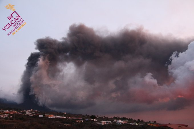
REMEMBER, ALL THAT TOXIC BLACK ASH WILL TURN TO CEMENT WHEN IT GETS WET! EVERYTHING IS COVERED IN IT. ROADS, ROOFS, SOME HOME ARE BURIED PAST THEIR WINDOWS WITH ASH! SOME UP TO THEIR ROOFS! WHAT WAS NOT BURIED IN LAVA, WILL BE SEALED IN ASH-CEMENT!!


spacer
spacer
![]()
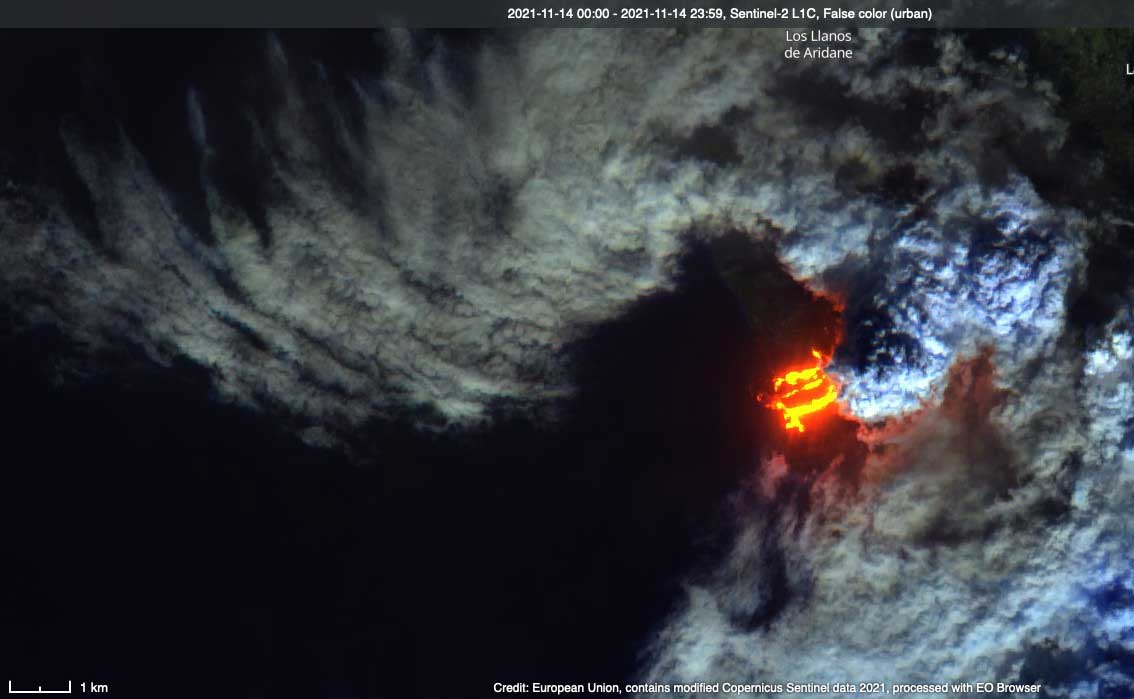
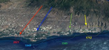
The eruption on La Palma has started 56 days ago and there is no end in sight! The 2021’s eruption becomes the longest on the island since the El Charco eruption in 1712. That’s an amazing 343 years! And it may even beat the records of San Antonio in 1678 (66 days), Tigalate in 1646 (82 days) and Tehuya in 1585 (84 days).
Almost two months after the beginning of its eruption, the Cumbre Vieja volcano on La Palma has claimed its first victim. According to reports from Spanish news wire EFE, a 70-year-old man was killed while working as a volunteer cleaning up volcanic ash when the roof of his own home in the neighbourhood of Corazoncillo collapsed on Friday. Meanwhile, ash removal continues in anticipation of rain!
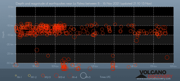
Many were hoping that the Cumbre Vieja eruption was starting to slow down, but a 5.0 magnitude earthquake on Saturday and several smaller tremors suggest that the volcano remains very active. Today, a M4.7 hit at a depth of 37 kilometers under Villa de Mazo, at the same location than yesterday’s quake.
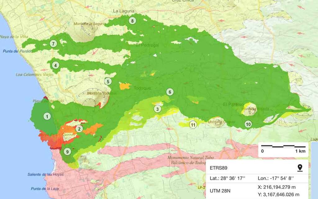
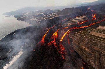
Moreover, new satellite images from Copernicus shows that the new lava delta that formed near the popular surf spot of Los Guirres beach, and fed by two lava flows, has now merged with the old one, forming a giant delta of more than 38.8 hectares (95.9 acres)
The video below clearly shows, the new island is fed by 2 distinctive lava flows.
The plume of the volcano
And the delta created by the lava, from the sea.
The latest data also show that lava has buried 5.5 hectares more land over the past 36 hours and destroyed two more buildings, taking the total to 2,618. These results suggest that the volcanic activity hasn’t slowed down or maybe even picked up over the weekend!
According to an update released by the Spain’s Department of National Security early Sunday, the lava flowing from the erupting Cumbre Vieja volcano now covers a surface area of 1,018.67 hectares.
The Spanish Navy has deployed two seabed seismometers in the surroundings of the Cumbre Vieja volcano in order to better monitor earthquake signals.
Meanwhile, many residents complain about not receiving any financial aid so far… Probably because its distribution has been excessively bureaucratic until now. There will not be a lot of fund left for the islanders! The natural disaster will turn into a societal collapse!
(Source)
spacer
|
spacer
This Video Is So Magnificent that
I Z👀med In!
Thank You @Jmglez_95 for taking it!
Very Beautiful! 🙏🏻#LaPalma #ErupcionLaPalma https://t.co/mIfInVd7TC pic.twitter.com/D4as7HE0Ed— 🎯𝓻𝓪𝓬𝓵𝓮 (@LetUsUniteHere) November 16, 2021
spacer
UPDATE: 11/15/2021; 4:42:02 PM
spacer
|
#LaPalma Via
|


spacer
|
|

spacer
spacer
![]()
Nov 15, 2021
spacer
![]()
La Palma, Canary Islands: eruption Sep 2021 – updates
La Palma volcano eruption update: explosive and effusive activity continue at stable levels
21:36 PM | BY: T
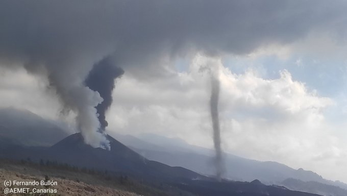
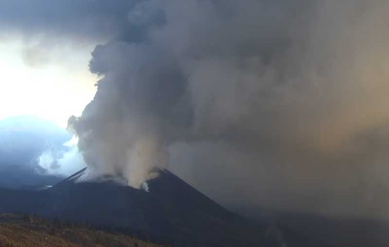
The eruption remains stable without significant changes in intensity. This morning, explosive activity at the vents was stronger again, producing ash plumes that rose to 8,000 ft (2.4 km) altitude and drifting west over the ocean. Lava continues to flow towards the ocean.
Sometimes, heat convection and winds created small heat “tornados” over the hot lava flow field, similar as dust devils in the desert, as the following video shows:
El volcán crea un pequeño TORNADO en la base de su cono, visible a kilómetros de distancia. Las altas temperaturas generadas por la lava y la meteorología cambiante han propiciado la creación de este tornado de cenizas y polvo en la zona de Las Manchas. #VolcandeLaPalma pic.twitter.com/tSLlgMU28E
— El Time (@ElTimeLaPalma) November 15, 2021
Strombolian explosions and lava spattering occur during phases, and can be seen especially well at night. Surface lava flows are active on the slopes of the cone, as sometimes lava overspills from the lower vents, although most of it continues to go directly into the tube system to feed the active flow downslope near the ocean. Only minor flow tongues actually touched the water today, as can be seen in this video from the Coast Guard:
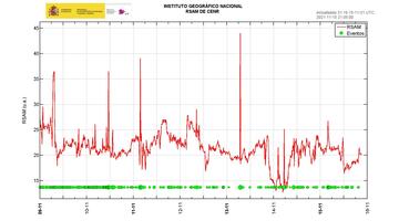
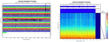
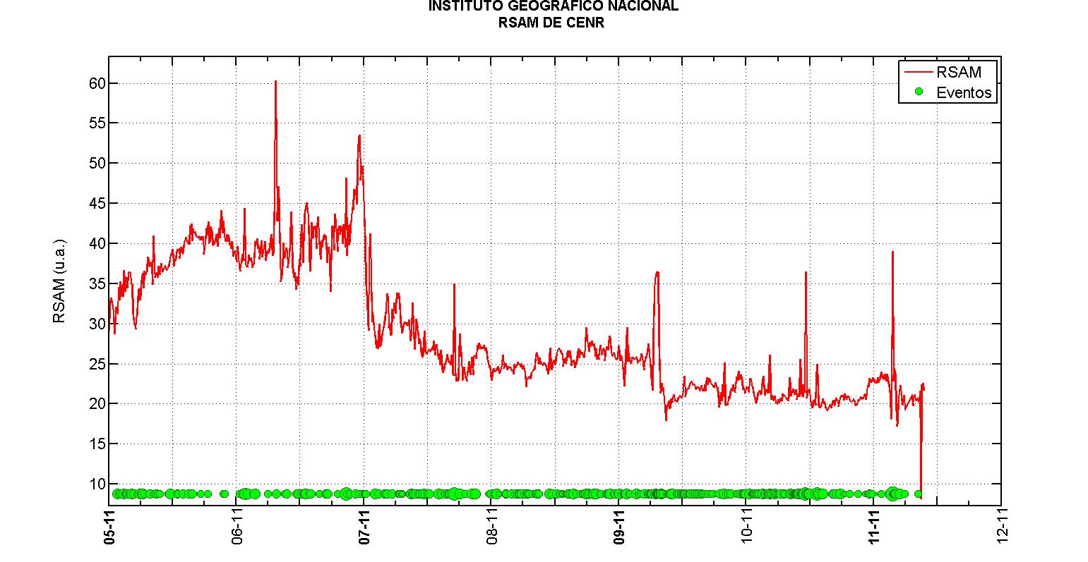
Volcanic tremor has stayed more or less stable, with typically short-lived fluctuations, but overall at levels comparable to the past 7 days, during which it has been showing a very slow decreasing trend. Earthquake activity also remains at similar (comparably low) levels as in the past days. During the latest 24 hours, there was only one quake of magnitude 4.4 along with 9 quakes between 3.0 and 3.9.
All in all, there is no sign the eruption might be ending soon.
- All news about: La Palma volcano
- Information about: La Palma volcano
spacer
UPDATE: 11/15/2021; 1:36:29 PM
spacer
|
spacer
Classification
| IEV | Volume of material thrown | Classification | Description | Height | Frequency |
|---|---|---|---|---|---|
| Examples | |||||
| 0 | <10 000 m³ | Hawaiian eruption | Effusive, not explosive | <100 m | Keep going |
| Mount Erebus (1963), Kīlauea (1977), Mauna Loa (1984), Pico Mawson (2006), Python de la Fournaise (2017), Erta Ale (2018) | |||||
| 1 | > 10 000 m³ | Strombolian | Light | 100 m – 1 km | Daily |
| Stromboli (since Roman times ), Nyiragongo (2002), Masaya (2008) | |||||
| 2 | > 1 000 000 m³ | Strombolian / Vulcanian | Explosive | 1–5 km | Biweekly |
| Unzen (1792), Cumbre Vieja (1949), Galeras (1993), Sinabung (2010), Cumbre Vieja (2021) | |||||
| 3 | > 10 000 000 m³ | Vulcanian / Peleana | Violent | 5–15 km | Every 3 months |
| Lassen Peak (1915), Nevado del Ruiz (1985), Soufrière Hills (1995), Pichincha (1999), Tungurahua (2006), Ontake (2014) | |||||
| 4 | > 0.1 km³ | Peleana / Subpliniana | Catastrophic | > 10 km | Every 18 months |
| Cotopaxi (1877), Pelée (1902), Paricutín (1944), Galunggung (1982), Reventador (2002), Eyjafjallajökull (2010), Calbuco (2015), de Fuego (2018) | |||||
| 5 | > 1 km³ | Pliniana | Cataclysmic | > 15 km | Every 12 years |
| Vesubio (79), Fuji (1707), Colima (1913), Agung (1963), Santa Helena (1980), El Chichón (1982), Hudson (1991), Chaitén Volcano (2008) Puyehue (2011) | |||||
| 6 | > 10 km³ | Pliniana / Ultrapliniana | Colossal | > 20 km | Between 50 to 100 years |
| Ilopango ( c. 450), Huaynaputina (1600), Laki (1783), Unknown (1808), Krakatoa (1883), Santa María (1902), Pinatubo (1991) | |||||
| 7 | > 100 km³ | Ultraplinian | Supercolossal | > 20 km | Between 500 to 1000 years |
| Cerro Blanco ( c. 2300 BC), Santorini (1610 BC), Paektu (946), Rinjani (1257), Tambora (1815), Lake Atitlán (84,000 BC) | |||||
| 8 | > 1000 km³ | Ultraplinian | Apocalyptic | > 25 km | Every 50,000 years [ 2 ] [ 3 ] |
| Yellowstone (640,000 BC), Toba (73,000 BC), Taupo (26,500 BC) | |||||
spacer
El volcán crea un pequeño TORNADO en la base de su cono, visible a kilómetros de distancia. Las altas temperaturas generadas por la lava y la meteorología cambiante han propiciado la creación de este tornado de cenizas y polvo en la zona de Las Manchas. #VolcandeLaPalma pic.twitter.com/tSLlgMU28E
— El Time (@ElTimeLaPalma) November 15, 2021
spacer
Columna de ceniza con actividad eléctrica a las 13.30 (hora canaria) desde Jedey / Column of ash with lighting at 1.30 pm (Canarian time) from Jedey pic.twitter.com/z4668LooDo
— INVOLCAN (@involcan) November 15, 2021
spacer
UPDATE: 11/15/2021; 10:49:48 AM
spacer
Nov 15, 2021
spacer
![]()

spacer
![]()
spacer
![]()
Nov 15, 2021
spacer
What the heck does it mean when they say it occurred at 1km?
| Monday, November 15, 2021 16:16 GMT (31 earthquakes) | ||||
| Nov 15, 2021 4:16 pm (GMT +0) (Nov 15, 2021 16:16 GMT) 4 minutes ago |
3.0
1 km |
30 km southeast of Santa Cruz de La Palma, Spain I FELT IT |
More Epicenter latitude / longitude: 28.44°N / 17.63°W↗ |
Map |
| Nov 15, 2021 4:16 pm (GMT +0) (Nov 15, 2021 16:16 GMT) 4 minutes ago |
3.0
1 km 16:32: Magnitude recalculated from 3.0 to 3.4 Hypocenter depth recalculated from 1.0 to 40.0 km (from 0.6 to 25 mi). |
30 km southeast of Santa Cruz de La Palma, Spain I FELT ITEpicenter location corrected by 25 km (16 mi) towards |
More Epicenter latitude / longitude: 28.5542°N / 17.8243°W↗ |
Map |
| Nov 15, 2021 4:12 pm (GMT +0) (Nov 15, 2021 16:12 GMT) 8 minutes ago |
3.5
26 km |
La Palma Island, 15 km southeast of Los Llanos de Aridane, Spain I FELT IT |
More | Map |
spacer
![]()
spacer
![]()
spacer
UPDATE: 11/15/2021; 1:58:28 AM
spacer

La Palma this morning. 11-15-21 Black Smoke is pouring out of the Volcano

spacer
| Date and time |
Mag Depth |
Location | Details | Map |
| Monday, November 15, 2021 07:06 GMT (20 earthquakes) | ||||
| ov 15, 2021 08:59 GMT 40 minutes ago |
2.3
12 km |
Spain: SW VILLA DE MAZO.ILP | More | Map |
| Nov 15, 2021 7:36 am (GMT +0) (Nov 15, 2021 07:36 GMT) 19 minutes ago |
3.4
14 km |
La Palma Island, 14 km southeast of Los Llanos de Aridane, Spain I FELT IT |
More | Map |
| Nov 15, 2021 7:06 am (GMT +0) (Nov 15, 2021 07:06 GMT) 29 minutes ago |
3.0
14 km |
La Palma Island, 14 km southeast of Los Llanos de Aridane, Spain I FELT IT |
More | Map |
| Nov 15, 2021 6:44 am (GMT +0) (Nov 15, 2021 06:44 GMT) 51 minutes ago |
2.3
14 km |
La Palma Island, 15 km southeast of Los Llanos de Aridane, Spain | More | Map |
| Nov 15, 2021 6:15 am (GMT +0) (Nov 15, 2021 06:15 GMT) 1 hour 19 minutes ago |
2.7
37 km |
La Palma Island, 8.9 km southeast of Los Llanos de Aridane, Spain | More | Map |
| Nov 15, 2021 6:13 am (GMT +0) (Nov 15, 2021 06:13 GMT) 1 hour 22 minutes ago |
2.5
16 km |
La Palma Island, 16 km southeast of Los Llanos de Aridane, Spain | More | Map |
| Nov 15, 2021 5:34 am (GMT +0) (Nov 15, 2021 05:34 GMT) 53 minutes ago |
2.7
33 km |
La Palma Island, 13 km south of Los Llanos de Aridane, Spain | More | Map |
| Nov 15, 2021 4:56 am (GMT +0) (Nov 15, 2021 04:56 GMT) 1 hour 31 minutes ago |
3.5
38 km |
La Palma Island, 12 km southeast of Los Llanos de Aridane, Spain I FELT IT |
More | Map |
| Nov 15, 2021 4:34 am (GMT +0) (Nov 15, 2021 04:34 GMT) 1 hour 54 minutes ago |
2.9
15 km |
La Palma Island, 15 km southeast of Los Llanos de Aridane, Spain | More | Map |
| Nov 15, 2021 4:31 am (GMT +0) (Nov 15, 2021 04:31 GMT) 1 hour 56 minutes ago |
2.5
12 km |
La Palma Island, 14 km southeast of Los Llanos de Aridane, Spain | More | Map |
| Nov 15, 2021 4:22 am (GMT +0) (Nov 15, 2021 04:22 GMT) 2 hours 5 minutes ago |
2.6
14 km |
La Palma Island, 14 km southeast of Los Llanos de Aridane, Spain | More | Map |
| Nov 15, 2021 4:11 am (GMT +0) (Nov 15, 2021 04:11 GMT) 2 hours 17 minutes ago |
2.6
15 km |
La Palma Island, 13 km southeast of Los Llanos de Aridane, Spain | More | Map |
| Nov 15, 2021 4:04 am (GMT +0) (Nov 15, 2021 04:04 GMT) 2 hours 23 minutes ago |
2.6
14 km |
La Palma Island, 14 km southeast of Los Llanos de Aridane, Spain | More | Map |
| Nov 15, 2021 4:01 am (GMT +0) (Nov 15, 2021 04:01 GMT) 2 hours 26 minutes ago |
2.9
14 km |
La Palma Island, 15 km southeast of Los Llanos de Aridane, Spain | More | Map |
| Nov 15, 2021 3:53 am (GMT +0) (Nov 15, 2021 03:53 GMT) 2 hours 34 minutes ago |
4.4
38 km |
La Palma Island, 13 km southeast of Los Llanos de Aridane, Spain I FELT IT – 4 reports |
More | Map |
| Nov 15, 2021 3:30 am (GMT +0) (Nov 15, 2021 03:30 GMT) 2 hours 57 minutes ago |
2.3
10 km |
La Palma Island, 12 km southeast of Los Llanos de Aridane, Spain | More | Map |
| Nov 15, 2021 1:44 am (GMT +0) (Nov 15, 2021 01:44 GMT) 5 hours ago |
2.8
14 km |
La Palma Island, 15 km southeast of Los Llanos de Aridane, Spain | More | Map |
| Nov 15, 2021 1:24 am (GMT +0) (Nov 15, 2021 01:24 GMT) 5 hours ago |
2.6
13 km |
La Palma Island, 13 km southeast of Los Llanos de Aridane, Spain | More | Map |
| Nov 15, 2021 1:20 am (GMT +0) (Nov 15, 2021 01:20 GMT) 5 hours ago |
2.6
13 km |
La Palma Island, 14 km southeast of Los Llanos de Aridane, Spain | More | Map |
| Sunday, November 14, 2021 22:14 GMT (22 earthquakes) | ||||
UPDATE: 11/14/2021; 10:15:09 PM
spacer
| Monday, November 15, 2021 03:53 GMT (5 earthquakes) | |||
| Nov 15, 2021 3:53 am (GMT +0) (Nov 15, 2021 03:53 GMT) 10 minutes ago |
4.2
24 km |
33 km southeast of Los Llanos de Aridane, Spain I FELT IT – 1 report |
 |
| Nov 15, 2021 3:53 am (GMT +0) (Nov 15, 2021 03:53 GMT) 1 hour 9 minutes ago |
4.4
38 km |
La Palma Island, 13 km southeast of Los Llanos de Aridane, Spain I FELT IT – 3 reports |
Intensity III |
This one (which was recalculated to a 4.4) looks like it was offshore:
 Spacer
UPDATE: 11/14/2021; 8:22:18 PM
spacer
🌋👀 #CumbreViejaVolcano #LaPalma #VolcanoLaPalma #eruptio #timelapse
The whole day… pic.twitter.com/Z7kGtjWWQo
— Ar-etsch (@ar_etsch) November 15, 2021
spacer
spacer
spacer
UPDATE: 11/14/2021; 4:05:12 PM
spacer
spacer
Así está rugiendo el volcán de La Palma. pic.twitter.com/5n1JB7PuJM
— La Palma | En Directo🌋 (@LaPalmaErupcion) November 14, 2021
spacer
DOES NOT SHOW ANY EVIDENCE OF A VOLCANO ON ITS LAST LEGS!!
spacer
![]()
Started streaming 16 minutes ago; 11/14/2021; 3:30 PM US CENTRAL TIME
spacer
The sound of rock fragments falling on the northeast slope of the Cumbre Vieja
volcano on the island of La Palma is perfectly heard
Se escucha perfectamente el sonido de los fragmentos de roca caer sobre la ladera al nordeste del volcán de Cumbre Vieja en la isla de La Palma pic.twitter.com/rtBQHME9g3
— 🏳️🌈Rubén López 🇪🇸 (@rubenlodi) November 14, 2021
spacer
![]()
Nov 14, 2021
spacer
UPDATE: 11/14/2021; 2:19:25 PM
Strombolian definition is – relating to volcanic eruptions that explode violently and eject incandescent dust, scoria, and bombs with little water vapor.
spacer
Vuelve la fase más stromboliana por la ladera este del volcán 🌋 de La Palma pic.twitter.com/ER9D9C5JR6
— 🏳️🌈Rubén López 🇪🇸 (@rubenlodi) November 14, 2021
spacer
VULCÃO CUMBRE VIEJA #LaPalma – 14/11/2021
HORÁRIO LOCAL: 18:34 pic.twitter.com/Nt2VGezhew— Tati Cruz (@Taticru79846829) November 14, 2021
spacer
UPDATE: 11/14/2021; 2:00:57 PM
spacer
![]()
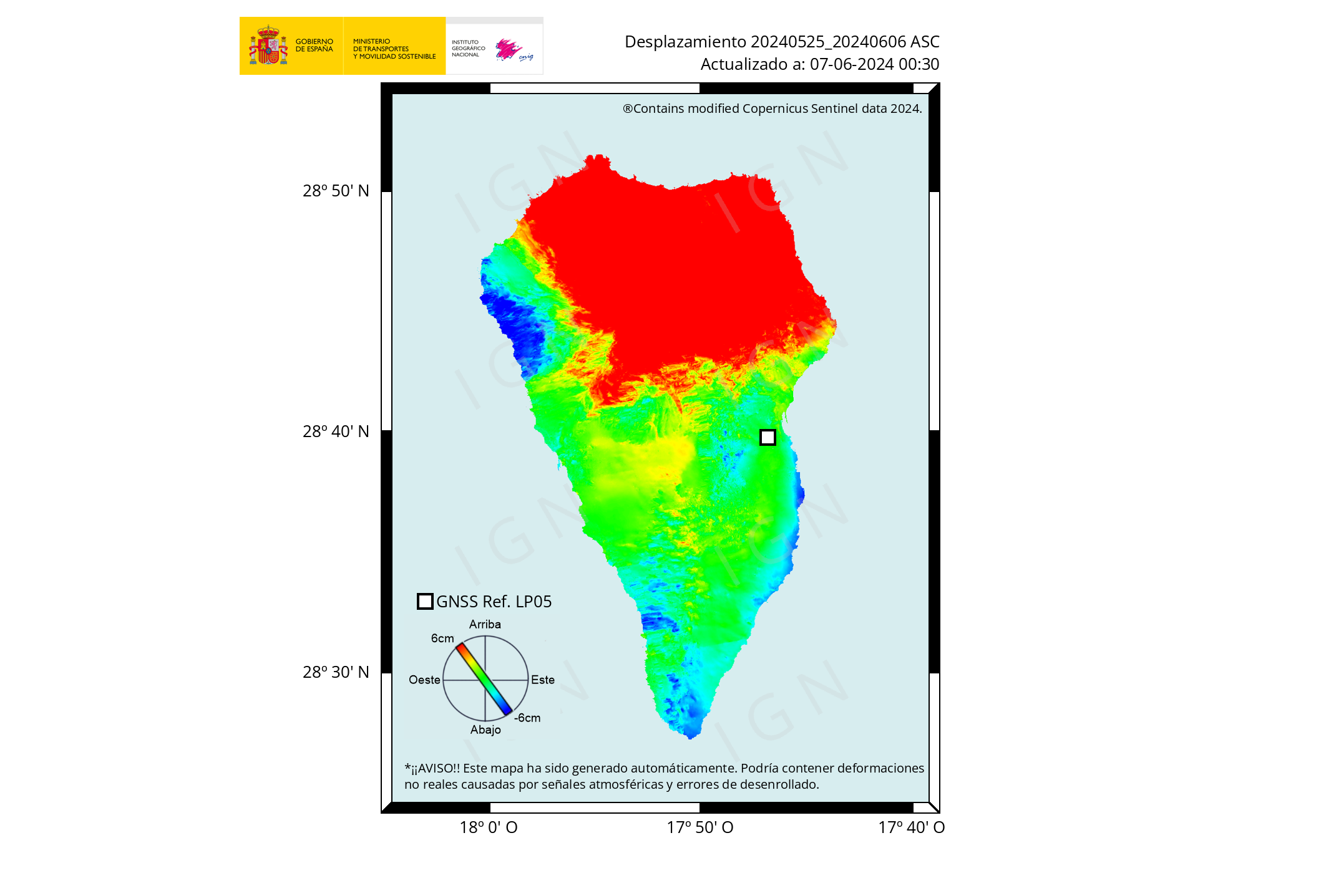
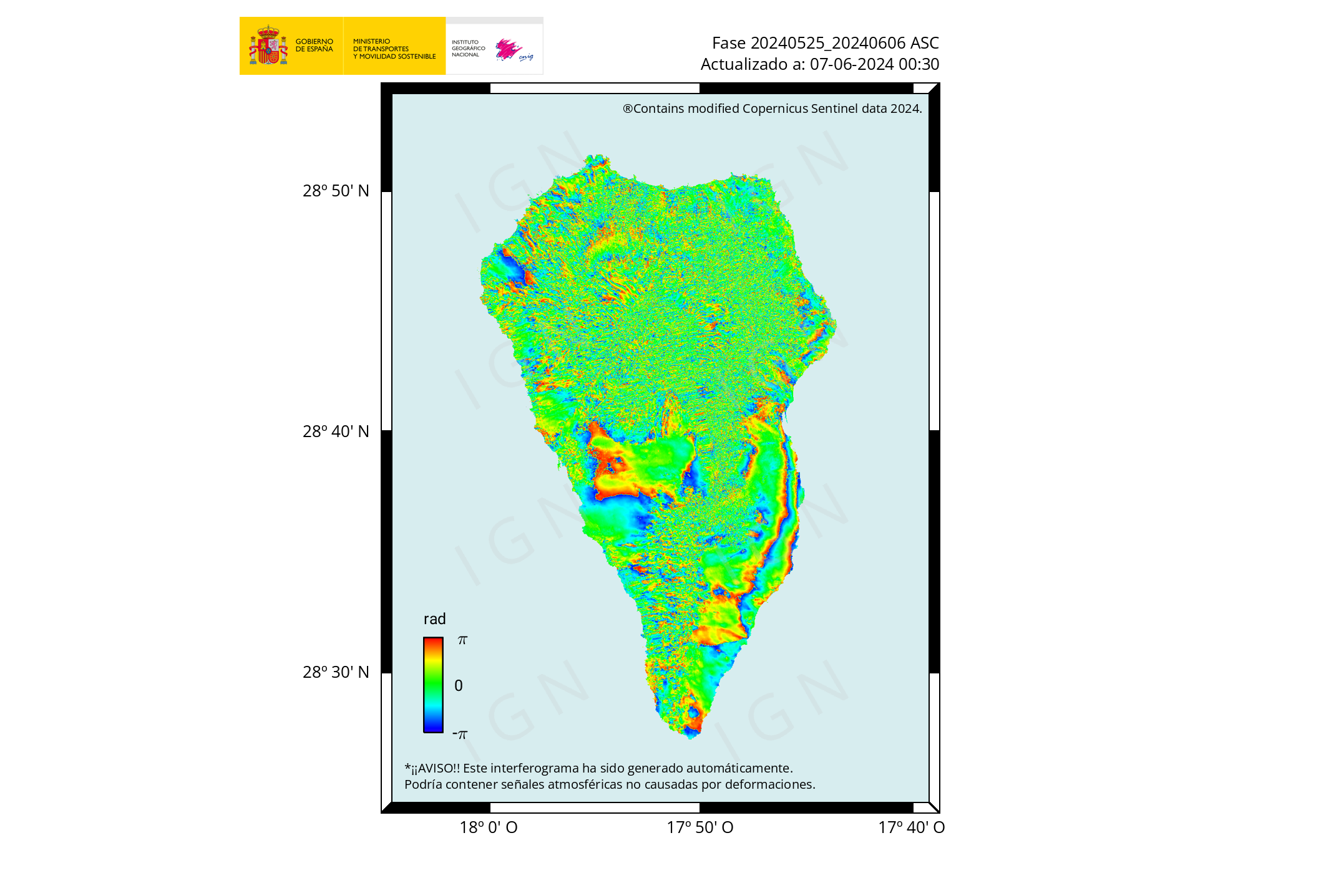
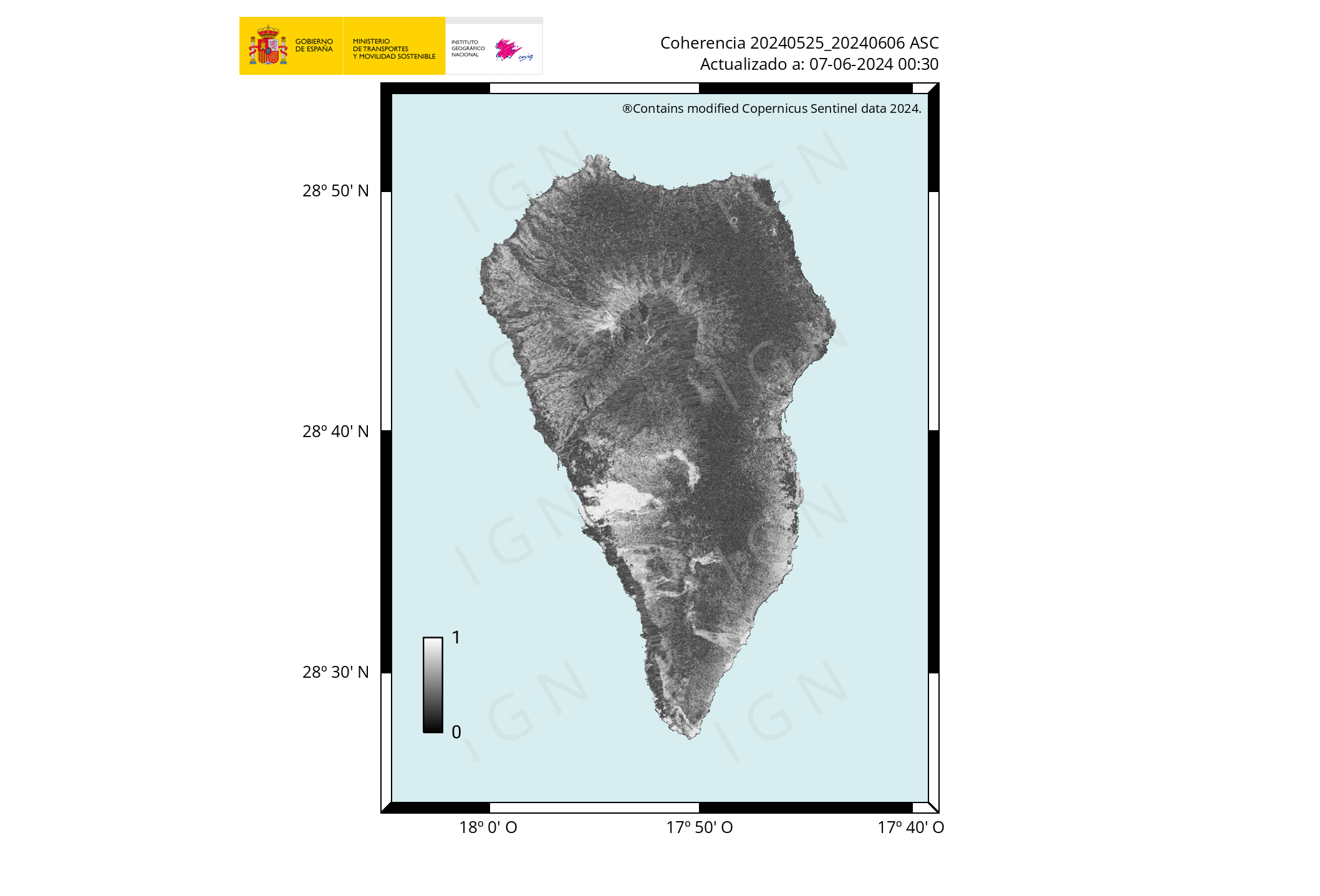
11-14-2021 10:00 UTCEruptive activity continues on La PalmaSince the last release, 34 earthquakes have been located in the area affected by the Cumbre Vieja volcanic reactivation, most of which have been located at depths greater than 30km. Only two of the earthquakes have been felt by the population during this period. The largest earthquake has been registered at 05:24 (UTC) today with a magnitude of 4.7 mbLg and has reached a maximum intensity of IV (EMS98) in the epicentral zone. The tremor signal has suffered a slight decrease in the last hours compared to previous days. The island’s network of permanent GNSS stations continues to show that after reversing the elevation of days 4 and 5 in station LP03, which is the closest to the eruptive centers, it remains at a lower level than previously established. station continues to register deformation towards the south. In the rest of the stations, the slight deflation possibly related to deep seismicity has moderated. In view of the calibrated image, a column height of 3,100 masla is estimated at 08:45 UTC. The height of the cone is measured obtaining a value of 1,130 m. above sea level. The IGN continues its presence on the island, where the CAVE (Center for Attention and Surveillance of Eruption) has been established. More information on the volcanic activity of the Eruption on La Palma The IGN will continue to monitor the seismic activity that can be followed through the Earthquake Viewer in the Canary Islands . |


|
TRACK 060 UP |
* regarding the last acquisition: |
 |
|
Displacement
|
Phase
|
Coherence
|
 |
 |
 |

spacer
![]()
La Palma, Canary Islands: eruption Sep 2021 – updates
Eruptive activity continues, but at lower levels now
The volcano continues to erupt, but activity remains lower compared to the past weeks. No significant explosive activity has occurred at the vents today, and lava effusion seems to have dropped as well, as less lava was seen reaching the new ocean delta today and only minor progress at few active fronts. The number of destroyed or damaged buildings increased to 2616.
Tremor is at similar levels as yesterday, but has been more fluctuating, sometimes dropping to very low values. This should suggest that magma supply is at times interrupted now although it is far from certain that this is the case. As the lava field is growing above an extended system of tubes, much lava can be stored in it without being easily visible.
New lava flow breakouts from the sides of the field could still occur any time easily and cause more destruction.
 The World of Earthquakes
@mondoterremoti
The lava delta that formed off the island of #LaPalma has now completely joined the delta that formed during the volcanic eruption of 1949. It is incredible to think that the whole island was created in this way. I Love The World
Translate Tweet
|


spacer
UPDATE: 11/14/2021; 12:49:51 PM
spacer
spacer
![]()
Nov 14, 2021
spacer
![]()
Nov 14, 2021

spacer
Now that you have seen the conflicting numbers above, compare them with the numbers from OCTOBER!!! They were already saying 8,000 people evacuated and from 1,000 to 2,000 buildings destroyed, in OCTOBER!! With so much conflicting information, so many things not even reported, reports being down graded without reason given, and lack of time stamps and incorrect or unclear translations… we have not idea what to believe or where to go for helpful and accurate data.
spacer
The pressure is mounting on the Spanish government to speed up aid delivery at the La Palma island where volcano has been erupting for over a month now. Thousands of building have been destroyed and more residents continue to flee. (Over 8,000 Evacuated is what the title reads. 2,000 Buildings engulfed is what the video title page says.)
#Spain #Volcano #LaPalma
TO WATCH THIS VIDEO ON UGETUBE: CLICK HERE

spacer
According to Camacho, only about 10 percent of the island has been impacted by the eruption.
So many tourists are interested in visiting “Cumbre Vieja” the area of volcanic activity that they have had to wait in line.
Last week, the Head of Tourism on the island of La Palma, Raul Camacho, said they are still welcoming visitors.
“Life is normal in the rest of the island,” he said.
Just that it is not that normal. Over 8,000 residents of La Palma have been forced to from their homes, and over a thousand houses have been destroyed.
Local farmers and workers have also been affected by the volcano, as the lava has ruined irrigation systems, roadways, and water pipes.
Tourists should not lose sight of the fact that this is also a tragedy. The police are overwhelmed in their efforts to protect nearly 8,000 evacuated homes and buildings from looters.
As of 26 October 2021, the lava that has flowed from the volcano (on 26 October estimated to be 215 million cubic metres[27]) has destroyed or affected over 2,100 buildings, over 66 kilometres (41 mi) of roads and covered an area of over 900 hectares (2,200 acres), with volcanic ash fall covering over 5,500 hectares (14,000 acres) within the limits of the monitored area, according to estimates from visual and radar satellite data by the Copernicus EMS. No casualties have been reported.[28]
spacer
UPDATE: 11/14/2021; 12:11:56 PM
spacer
![]()
spacer
![]()
Started streaming 5 hours ago; 11/14/21; 6:50 AM USA CENTRAL TIME
spacer
spacer
UPDATE: 11/14/2021; 5:33:46 AM
spacer
A 4.7 and a 4.5 only 5 hours apart.
| Sunday, November 14, 2021 10:20 GMT (22 earthquakes) | ||||
| Nov 14, 2021 10:20 am (GMT +0) (Nov 14, 2021 10:20 GMT) 41 minutes ago |
4.5
37 km |
La Palma Island, 14 km southeast of Los Llanos de Aridane, Spain I FELT IT – 23 reports |
More Estimated released energy: 3.5 x 10¹¹ joules (98.6 megawatt hours, equivalent to 84.8 tons of TNT) |
Map
|
| Nov 14, 2021 8:24 am (GMT +0) (Nov 14, 2021 08:24 GMT) 2 hours 38 minutes ago |
2.1
13 km |
La Palma Island, 13 km southeast of Los Llanos de Aridane, Spain | More | Map |
| Nov 14, 2021 6:35 am (GMT +0) (Nov 14, 2021 06:35 GMT) 4 hours ago |
2.3
14 km |
La Palma Island, 13 km southeast of Los Llanos de Aridane, Spain | More | Map |
| Nov 14, 2021 6:31 am (GMT +0) (Nov 14, 2021 06:31 GMT) 5 hours ago |
2.5
13 km |
La Palma Island, 13 km southeast of Los Llanos de Aridane, Spain | More | Map |
| Nov 14, 2021 6:28 am (GMT +0) (Nov 14, 2021 06:28 GMT) 5 hours ago |
2.5
14 km |
La Palma Island, 14 km southeast of Los Llanos de Aridane, Spain 1 report | More | Map |
| Nov 14, 2021 5:24 am (GMT +0) (Nov 14, 2021 05:24 GMT) 6 hours ago |
4.7
37 km |
La Palma Island, 13 km southeast of Los Llanos de Aridane, Spain I FELT IT – 39 reports |
More Estimated released energy: 7.1 x 10¹¹ joules (197 megawatt hours, equivalent to 169 tons of TNT) More info |
Map |

spacer
[10:58h] The island was waked up at 05:24h by a mbLg quake of 4.7. Another 4.5 followed at 10:20h. Both in the lower chamber. Video of this morning. Vulcan seems slightly reactivated. Also 2 cm inflation at station Jedey reported./rf #LaPalma #erupciónenlapalma #Tajogaite pic.twitter.com/0cytmNCF6Z
— Roger (@efadi_LP) November 14, 2021
spacer
![]()
Nov 14, 2021
spacer
spacer
UPDATE: 11/13/2021; 9:39:38 PM
spacer;
The Lone Survivor on #LaPalma.
📸 @SantaCruz_love pic.twitter.com/RvUjoa9uOU— 🎯𝓻𝓪𝓬𝓵𝓮 (@LetUsUniteHere) November 14, 2021
spacer
El volcán de La Palma expulsando material piroclástico. pic.twitter.com/yZEpYnJJWm
— La Palma | En Directo🌋 (@LaPalmaErupcion) November 13, 2021
spacer
 INVOLCAN
 @involcan
Fotografía desde Tacande a las 19.30 (hora canaria) en la que se observa una nube de ceniza / Photograph from Tacande at 7:30 pm (Canarian time) in which an ash cloud is observed
Translate Tweet
|
spacer
UPDATE: 11/13/2021; 4:55:12 PM
spacer
spacer
La Palma, Canary Islands: eruption Sep 2021 – updates
La Palma volcano eruption update: stable activity, lava continues to flow into the ocean
17:32 PM | BY: T

Activity continues with no significant changes, with similar intensity as during the past days, while on a very gradually decreasing trajectory. The eruption is now mainly effusive (i.e. producing lava flows). At the vents, explosive activity has been only intermittent and comparably weak recently, although still able to produce plumes rising to up to 2-3 km during phases of more intense activity such as this morning.
Most of the time, however, only dense steam plumes rise from the craters, while fluid, degassed magma continues to arrive and flow through a tube system to arrive at the new active sea entry, where a second delta is now growing. Watch some videos taken by staff from IGN:
🌋 Las coladas de lava van cubriendo la playa de los #Guirres, densas columnas de vapor de agua y gases.#IGNSpain #ErupcionLaPalma #VolcandeLaPalma @mitmagob @CabLaPalma @112canarias @IGME1849 @IGeociencias @CSIC @VolcansCanarias @DgCanarias @ULL @ULPGC @AEMET_Canarias @RTVCes pic.twitter.com/WQHhrmTFFT
— IGN-CNIG (@IGNSpain) November 12, 2021
Columnas de vapores de agua y gases en el delta lávico al producirse el contacto de la lava con el agua del Atlántico.#IGNSpain #ErupcionLaPalma #VolcandeLaPalma @mitmagob @CabLaPalma @112canarias @IGME1849@CSIC @VolcansCanarias @DgCanarias@ULL @ULPGC @AEMET_Canarias @RTVCes pic.twitter.com/YEYhKiDDwD
— IGN-CNIG (@IGNSpain) November 12, 2021
Earthquakes slow down
Volcanic tremor is stable, at similar levels as during the past days with some increase overall today. Seismic activity has calmed down a lot, with only 10 quakes above magnitude 3 recorded in 24 hours. However, these include a strong quake of magnitude 5.0 occurred this morning shortly before 7 a.m., again in the deeper layer at 38 km depth.
Ground deformation continues to show a weak trend of deflation. All in all, the eruption does not seem to be ending soon, but likely is in its long tailing-off phase.
- All news about: La Palma volcano
- Information about: La Palma volcano
spacer
Imágenes tomadas desde el embalse de Dos Pinos a las 16.30 (hora canaria) / Images taken from the Dos Pinos dam at 4.30 pm (Canarian time) pic.twitter.com/kIya2wL0hQ
— INVOLCAN (@involcan) November 13, 2021
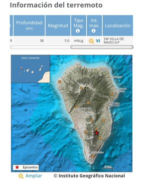
11-13-2021 10:00 UTCEruptive activity continues on La PalmaSince the last statement, 31 earthquakes have been located in the area affected by the volcanic reactivation of Cumbre Vieja, most of which have been located at depths greater than 30 km. Only one of the earthquakes has been felt by the population during this period. It is the largest earthquake , registered at 06:56 (UTC) today with a magnitude of 5.0 mbLg and which has reached a maximum intensity of IV-V (EMS98) in the epicentral zone. The tremor signal continues at low values. As yesterday, the island’s network of permanent GNSS stations shows that after reversing the elevation of days 4 and 5 in station LP03, which is the closest to the eruptive centers, it remains at a level lower than previously established; however, the station continues to register deformation towards the south. In the rest of the stations, the slight deflation possibly related to deep seismicity has moderated. In view of the calibrated image, a column height of 3,100 m is estimated at 08:45 UTC . with a southwest direction. The height of the cone is measured obtaining a value of 1,130 m. above sea level. The IGN continues its presence on the island, where the CAVE (Center for Attention and Surveillance of Eruption) has been established. More information on the volcanic activity of the Eruption on La Palma The IGN will continue to monitor the seismic activity that can be followed through the Earthquake Viewer in the Canary Islands . |


Noviembre 13, 2021
Continúa la actividad eruptiva con vigorosas exhalaciones, en #CumbreVieja #LaPalma #ErupcionLaPalma #Canarias #España 🇪🇸
Vía @involcan pic.twitter.com/J4zFjFzk6W— Geól. Sergio Almazán (@chematierra) November 13, 2021
 @LetUsUniteHere
|

![]()
Nov 13, 2021
 meteo365.es
@ meteo365_es
Volcano eruption – Sense a 4.5 magnitude earthquake in #LaPalma – this earthquake has reached a 5.1 magnitude at its peak Map:
 meteo365.es/terremotos/ meteo365.es/terremotos/ |

 Miguel Alonso #SomosLaPalma
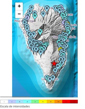
#Earrowing earthquake with the epicenter to the SW in #VillaDeMazo . Third equality at 5 mbLg. Fourth maximum earthquake since the beginning in #LaPalma . Maximum intensity record! provisional VI low . If you felt it, fill in the questionnaire
 ign.es/web/resources/ ign.es/web/resources/
Quote Tweet
@IGN_Sismology
·
#earthquake 11/13/2021 06: 56: 02 UTC SW VILLA DE MAZO_ILP mag = 5.0 depth = 38km revised calculation ign.es/web/resources/
|

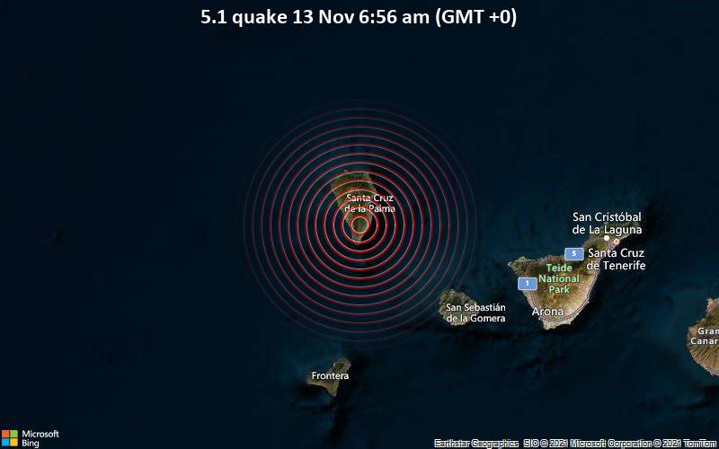
| Saturday, November 13, 2021 07:03 GMT (26 earthquakes) | |||
| Nov 13, 2021 06:56 GMT Nov 13, 2021 6:56 am (GMT +0) 17 minutes ago |
5.1
38 km |
I FELT IT – 40 reports |
|
Data for the same earthquake reported by different agencies
| Mag. | Depth | Location | Source |
| 5.1 | 38 km | CANARY ISLANDS, SPAIN REGION | IGN |
| 5.1 | 49 km | Spain: ATL | EMSC |
UPDATE: 11/13/2021; 1:07:57 AM
|

|

Source parameters provided by:
Instituto Geografico Nacional — Madrid, Spain (MAD)
 Diaries of a Robot
@RobotDiaries
An earthquake of magnitude 5.1 has occurred in NE FUENCALIENTE DE LA
PALMA.IL on the date 11/13/2021 6:56:02 at the following location: 28.5636, -17.8329, at a distance of 219.8 Kms from GC. #earthquake #LaPalma #earthquake
|

[09:09h UTC] The vulcan is forcelwss today in regard to ash, gas and noise production, but it still produces heaps of lava. Skies have been illuminated the whole night. /rf #LaPalma #Tajogaite #ErupcionLaPalma pic.twitter.com/pjZGAgyCkl
— Roger (@efadi_LP) November 12, 2021
![]()
Nov 12, 2021; 8 PM US Central Time
La Palma, Canary Islands: eruption Sep 2021 – updates
Magnitude 5 quake shakes island early in the morning
![]()
![]()
Started streaming 15 minutes ago; 11/12/2021; 3:03:58 PM
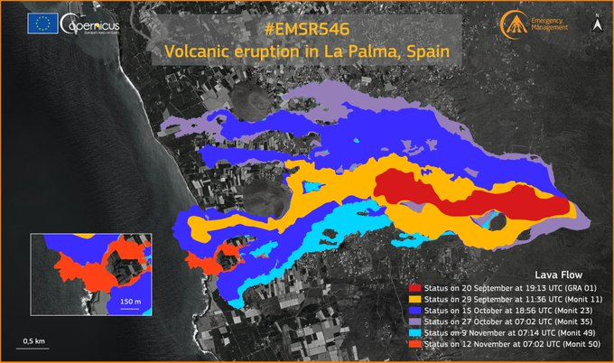
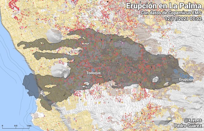
 [11/12/2021 07:02] Perimeter of the lava flow, at 07:02 today the 12th of # EMSR546 . It occupies an area of 1018.95 hectares, destroying 2616 buildings and possibly damaging another 115. #erupcionlapalma #VolcandeLaPalma #LaPalma
|
Recent Map Shows Definite Ground Changes On La Palma Is There Enough For Mega Tsunami

Images may be subject to copyright Lean More
Recent Map Shows Definite Ground Changes On La Palma Is
Lpmtg la palma mega tsunami general stomy saturday threads: >current news rtvc.es en … 346384619: if the usa fought the ussr how badly would have the ussr lost? 346386027: covid is an airborne hiv like virus leading to an aids like illness in a long run. 346386562: should i take the jab or not? serious question. Recent estimates show that around half of the uk’s 8,300 petrol stations were without fuel this weekend. a lack of workers has forced farmers to leave crops to rot in the ground and to send animals for slaughter without any certainty that abattoirs have enough workers to process them. The version table provides details related to the release that this issue rfe will be addressed. unresolved: release in which this issue rfe will be addressed. resolved: release in which this issue rfe has been resolved. fixed: release in which this issue rfe has been fixed.the release containing this fix may be available for download as an early access release or a general availability release. Earthquake mag. 5.3 shook los angeles at 12:30 pm pacific on april 5th. 04 01 2018 update 9:30 pm mtn april 1st – chinese space lab has crashed into southern pacific ocean. Browse our listings to find jobs in germany for expats, including jobs for english speakers or those in your native language.
Images may be subject to copyright Lean More
Recent Map Shows Definite Ground Changes On La Palma Is
We would like to show you a description here but the site won’t allow us. A book is a set of sheets, printed or manuscript, of the same size, bound together in a certain order and enclosed by a cover the book is the most widespread vehicle of knowledge. all printed works, including books, called literature. books are therefore literary works. in library and information science a book called monograph, for. More than a year and a half into the covid 19 pandemic, burnout seems to be on everyone’s lips. many of us didn’t realise what had hit us when we scrambled to adjust to the sudden upheaval of the workplace, switching to remote work with little or no preparation, or deemed an essential worker and asked to continue business as usual in highly unusual circumstances. Below is the list of the various crimes and beds recorded throughout France per year. you can click the column headers to sort. the “var.” represents the 2-year variation of this column. (for 2012, no changes as this is the first year for which we have data). An electronic book, [1] digital book or cyber book, conocido en ingl s como e book or ebook, es la publicaci n electr nica o digital de un libro.es major diferenciar el libro electr nico o digital de uno de los devices ms popularizados para su lectura: el lector de libros electr nicos, oe reader, en su versi n English aunque a veces defined as “a verse n.
The Volcano On La Palma In The Canary Islands Will Not Cause A Mega Tsunami
the cumbre vieja volcano on the island of la palma in the canary islands, a spanish archipelago located off the coast of northwestern africa, erupted on sept.
Related image with recent map shows definite ground changes on la palma is there enough for mega tsunami

![]()
Nov 12, 2021
![]()
Nov 12, 2021
 11/12/2021 The earthquake, located at Villa de Maso, about 38 kilometers deep, occurred early in the morning. The eruption of the Cambre Vieja volcano on the island of La Palma continues with a slight decrease in seismic activity in the early morning. However, this does not mean that the likelihood of continued registration of earthquakes felt by the population is excluded, as happened early this Friday morning when the 4.3 earthquake shook Bonita Island again. According to calculations compiled by the National Geographic Institute (IGN), the aforementioned movement, located in Villa de Maso, occurred – about 38 kilometers deep, the area that recorded the most earthquakes last Thursday in both number and magnitude. , Maria José Blanc assured the media. It should be noted that in her last media presentation, the expert assured that the activity recorded in the last 24 hours has kept the possibility of a new series of earthquakes intact, which can be felt by the population and, in turn, cause landslides in sloping areas. Thus, this new movement lends the continuity of the little respite that the process gave Isla Bonita throughout the night, when only eight shocks were recorded, the largest of which has a magnitude of 3.3.3. #volcano #LaPalma #Spain #lava #eruptions #research #science #news #planet
![]()
Nov 12, 2021
Imágenes tomadas a las 13.30 (hora canaria) desde el Mirador Astronómico del Llano del Jable / Footage taken at 1.30 pm (Canarian time) from the Llano del Jable Astronomical Viewpoint pic.twitter.com/HEwzzAGCHO
— INVOLCAN (@involcan) November 12, 2021
|
Is seismicity decreasing in Cumbre Vieja? / Is seismicity decreasing in Cumbre Vieja?
facebook.com/INVOLCAN/posts
|
Light mag. 4.1 earthquake – La Palma Island, 12 km southeast of Los Llanos de Aridane, Spain, on Friday, Nov 12, 2021 8:28 am (GMT +0) – 9 hours ago
12 Nov 08:34: Magnitude recalculated from 4.2 to 4.5. Hypocenter depth recalculated from 22.0 to 47.0 km (from 13.7 to 29 mi). Epicenter location corrected by 17 km (10.5 mi) towards WSW.
12 Nov 08:39: Magnitude recalculated from 4.5 to 3.8. Hypocenter depth recalculated from 47.0 to 30.0 km (from 29 to 18.6 mi). Epicenter location corrected by 23 km (14 mi) towards NE.
12 Nov 10:04: Magnitude recalculated from 3.8 to 4.1. Hypocenter depth recalculated from 30.0 to 40.0 km (from 18.6 to 25 mi). Epicenter location corrected by 18 km (11 mi) towards SW.
Local time at epicenter: Friday, Nov 12, 2021 8:28 am (GMT +0)
Magnitude: 4.1
Depth: 40.0 km
Epicenter latitude / longitude: 28.6°N / 17.81°W↗
Antipode: 28.6°S / 162.19°E↗
Nearest volcano: La Palma (18 km / 11 mi)
spacer
La Palma Watchers,Yesterday saw the highest increase in seismic activity since the eruption began. A M5.4 quake was reported in the morning and was widely felt across the island. It was reported to be the strongest quake felt since the eruption began. It was followed by an intense swarm of quakes at a depth of 36 km. The quake was quickly and heavily downgraded to M4.8. Many people went onto the Spanish earthquake reporting agency’s website to complain about the downgrade, which caused no small degree of controversy.Intensities can vary even in the same size magnitude quakes, but most people felt the degree of downgrade for this quake was exaggerated and not accurate. Today, another M4.8 quake was reported, but then upgraded to M5.0. One wonders whether yesterday’s posted “scoldings” had an effect on today’s reporting for reasons you will see in the next paragraph.In most cases, when earthquake magnitudes are reported, there is an automated figure that the computers spit out from the seismic data within seconds, then a designated person is appointed to “edit” this calculated figure with what often appears to be their own subjective reasoning, some higher level directive, or a standard protocol for censoring the magnitude of earthquakes. I have documented this phenomenon hundreds of times over the years. The “standard” downgrade for a quake this size is usually around 0.5 magnitude [half of one magnitude], but this downgrade was even higher.“We don’t want to scare the public,” seems to be the thinking in such cases, whereas accurate reporting should be the priority, so that the public can prepare accordingly.Locals on La Palma were warned again today of the possibility of larger magnitude quakes occurring within hours or days.For the past two days, the Spanish Navy has brought in four amphibious boats transporting local farmers, taking them to shoreline areas where they can then get to their trapped banana crops. With roads blocked by lava and ash, this is the only way they can get in to assess the damage and/or irrigate their crops – what’s left of them.In other news, it has been reported today that five of six honeybee hives were “rescued” by the military. These hives were dug out of a 50-day accumulation of ash and were completely covered. The bees were still alive and were transported to a safer area. As a beekeeper for many years, I am amazed these hives could have survived such destruction and depth of ash for this amount of time.Watch and see!The Watchman
![]()
|
@LetUsUniteHere
|

![]()
Nov 11, 2021

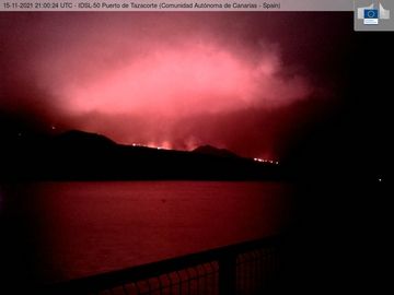
📍El mayor terremoto desde la erupción ‘sacude’ La Palma
📍El mayor terremoto desde la erupción ‘sacude’ La Palma #LaPalma #LaPalma #LaPalma #LaPalma #LaPalma #LaPalma https://t.co/6DG2MahAQw
Publicado en Twitter por Erupción La Palma | ÚLTIMA HORA
![]()
Nov 11, 2021
Premiered 2 hours ago
![]()
Nov 11, 2021s
![]()
Nov 11, 2021
![]()
Nov 11, 2021

![]()
La Palma volcano update: Magnitude 5 quake shakes island early in the morning
09:54 AM | BY: T
A magnitude 5.0 quake hit 36 km below the island this morning at 3.37 a.m. and was felt by thousands of people.
On the other hand, shallower quakes have become less in numbers and magnitude with “only” 75 quakes in total during the latest 24 hours.
The eruption continues but has been decreasing in visual and instrumental intensity: at the vent, explosions and ash emissions have become smaller and rarer, while lava effusion continues. Most of the time, only a dense steam plume is rising from the main crater.
Volcanic tremor is similar as yesterday and on a (very) gradually decreasing trajectory. The same is true for ground deformation and reported values of gas emissions.
The new lava sea entry at Los Guirres seems no longer or much less active than yesterday this morning, judging from the webcam views, but this needs confirmation. Here’s an impressive video from yesterday’s activity:
All options are on the table, but in any case, the first scenario might seem more likely, i.e. that the eruption might be ending rather sooner (few weeks from now?) than later.

|
During the past 24 hours, La Palma volcano was shaken by 1 quake of magnitude 5.0,2 quakes between 4.0 and 5.0, 41 quakes between 3.0 and 4.0, and 43 quakes between 2.0 and 3.0. That 4.8 upgraded to a 5. #LaPalma24HrQuakes
|
spacer

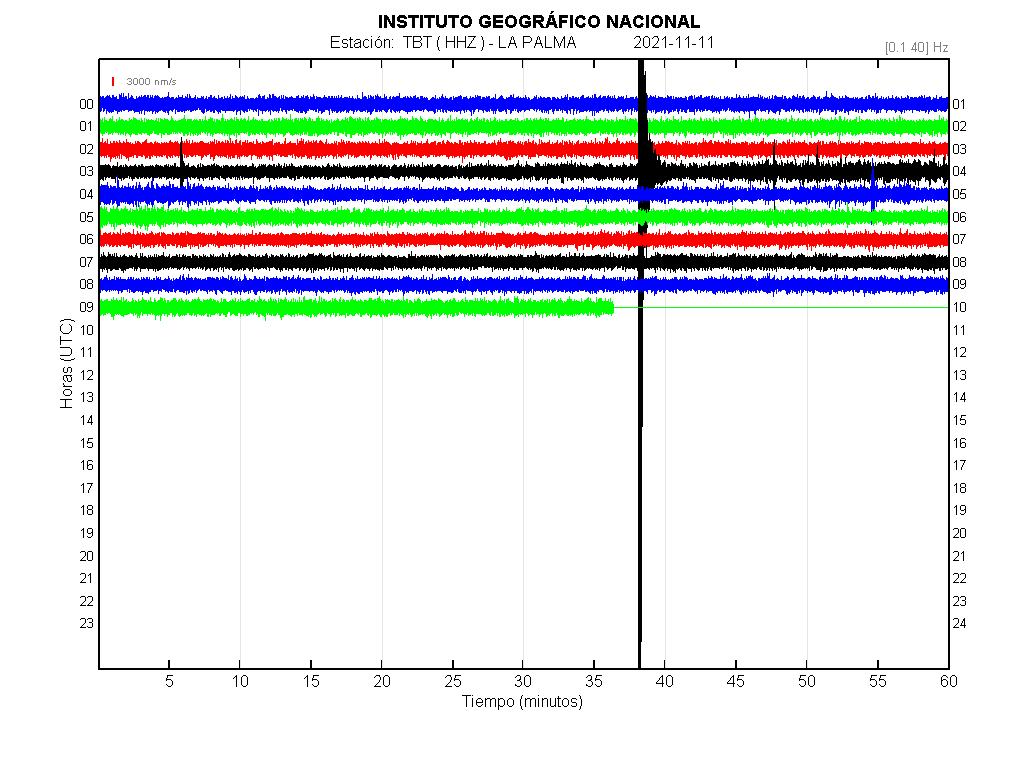
| Nov 11, 2021 3:37 am (GMT +0) (Nov 11, 2021 03:37 GMT) 3 hours 42 minutes ago |
5.0
37 km |
La Palma, 12 km southeast of Los Llanos de Aridane, Spain I FELT IT – 95 reports |
More | Map |
Moderate mag. 5.0 earthquake – La Palma, 12 km southeast of Los Llanos de Aridane, Spain, on Thursday, Nov 11, 2021 3:37 am (GMT +0) – 3 hours 44 minutes ago
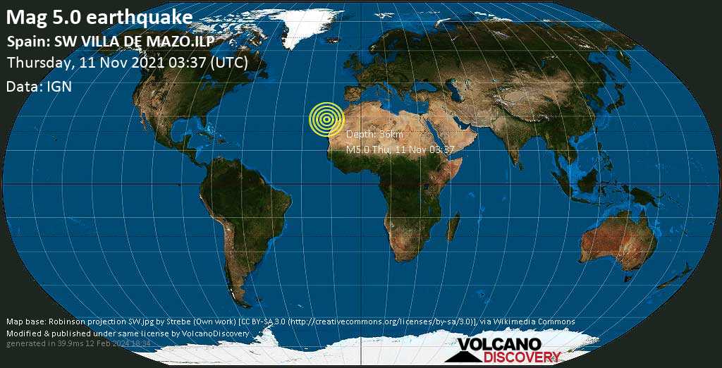
Moderate magnitude 5.0 earthquake at 37 km depth
11 Nov 03:42: Now using data updates from IGN
11 Nov 03:51: Magnitude recalculated from 4.8 to 5.0. Hypocenter depth recalculated from 38.0 to 37.0 km (from 24 to 23 mi). Epicenter location corrected by 0.7 km (0.4 mi) towards NNE.
Local time at epicenter: Thursday, Nov 11, 2021 3:37 am (GMT +0)
Magnitude: 5
Depth: 37.0 km
Epicenter latitude / longitude: 28.58°N / 17.8317°W↗
Antipode: 28.58°S / 162.168°E↗
Nearest volcano: La Palma (1 km / 1 mi)
Nearby towns and cities:
6 km (4 mi) WSW of Mazo (pop: 4,810) –> See nearby quakes!
10 km (6 mi) N of Fuencaliente de la Palma (La Palma Island) (pop: 1,890) –> See nearby quakes!
12 km (8 mi) SE of Los Llanos de Aridane (La Palma Island) (pop: 20,800) –> See nearby quakes!
13 km (8 mi) SSW of Santa Cruz de La Palma (La Palma Island) (pop: 17,100) –> See nearby quakes!
23 km (14 mi) SSW of Garachico (Santa Cruz de Tenerife, Kanarische Inseln) (pop: 6,000) –> See nearby quakes!
28 km (17 mi) SSE of Santo Domingo (pop: 1,930) –> See nearby quakes!
71 km (44 mi) NW of Vallehermoso (pop: 3,300) –> See nearby quakes!
89 km (55 mi) NW of San Sebastian de La Gomera (Santa Cruz de Tenerife) (pop: 8,960) –> See nearby quakes!
148 km (92 mi) W of San Cristobal de La Laguna (pop: 150,700) –> See nearby quakes!
155 km (96 mi) W of Tenerife (pop: 222,400) –> See nearby quakes!
Broken Clouds
 10.4°C (51 F), humidity: 68%, wind: 3 m/s (6 kts) from NNW
Primary data source: IGN (Instituto Geográfico Nacional)
Estimated released energy: 2 x 10¹² joules (554 megawatt hours, equivalent to 477 tons of TNT) More info
| Mag. | Depth | Location | Source |
| 5.0 | 37 km | Spain: SW VILLA DE MAZO.ILP | IGN |
| 4.7 | 45 km | Spain: SW VILLA DE MAZO.ILP | EMSC |
User reports for this quake (94)
Aftershocks
Recorded aftershocks, latest first (9 quakes so far, frequently updated)
-
11 Nov 2021 05:52 UTC
| M 2.7 |
14 km (8.7 mi) depth|
2 km (1 mi) distance| EMSC | Details
-
11 Nov 2021 04:54 UTC
| M 3.5 |
34 km (21.1 mi) depth|
10 km (6 mi) distance| IGN | Details
-
11 Nov 2021 04:06 UTC
| M 3.0 |
33 km (20.5 mi) depth|
2 km (1 mi) distance| IGN | Details
-
11 Nov 2021 04:03 UTC
| M 3.0 |
35 km (21.7 mi) depth|
2 km (1 mi) distance| IGN | Details
-
11 Nov 2021 04:01 UTC
| M 3.1 |
35 km (21.7 mi) depth|
4 km (2 mi) distance| IGN | Details
-
11 Nov 2021 03:59 UTC
| M 3.0 |
35 km (21.7 mi) depth|
8 km (5 mi) distance| IGN | Details
-
11 Nov 2021 03:52 UTC
| M 2.9 |
33 km (20.5 mi) depth|
5 km (3 mi) distance| EMSC | Details
-
11 Nov 2021 03:50 UTC
| M 3.1 |
34 km (21.1 mi) depth|
3 km (2 mi) distance| IGN | Details
-
11 Nov 2021 03:47 UTC
| M 3.3 |
33 km (20.5 mi) depth|
1 km (1 mi) distance| IGN | Details
|
INVOLCAN
@involcan
Photograph taken from El Paso at 6.30 pm (Canary time) in which the volcanic plume of ash and gases can be observed / Photograph taken from El Paso at 6.30 pm (Canarian time) in which the volcanic plume of ash and gases can be observed
 |
Day 53: La Palma Volcano, Canary Islands – Nov 10, 2021 – SMOKE AND ASH COVER THE VOLCANO

![]()
Nov 10, 2021
![]()
Nov 10, 2021
La Palma volcano update: Earthquakes increase again, especially at depth
17:11 PM | BY: T
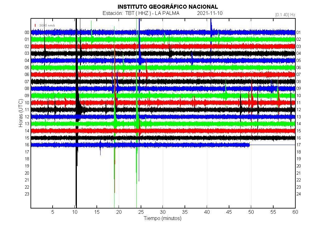
The number of quakes under the island has increased significantly again during the latest 24 hours, in particular the occurrence of quakes in the deeper layer around 35 km, where two shocks of magnitudes 4.2 and 4.8were recorded today, at 11.10 a.m. and 1.23 p.m., respectively.
Both quakes were felt widely on the whole island, in particular the magnitude 4.8 event, which is one of the strongest in the current seismic and volcanic crisis. As to their meaning, it can only be speculated uponwhether they signify a potential re-supply of magma at depth or perhaps the opposite, i.e. internal adjustments after magma has left storage areas below. A better interpretation of these events is likely only to follow after more time has passed and other data has been collected to study the events from an afterwards perspective.
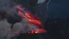
In the meanwhile, volcanic tremor continues to follow its slowly decreasing trend as yesterday and is low when compared to previous weeks, but still significant, in tandem with continued lava effusion that resulted in the spectacular lava flows falling over the sea cliff today mentioned in the previous update.
incredible video of glowing lava falls overflowing cliff
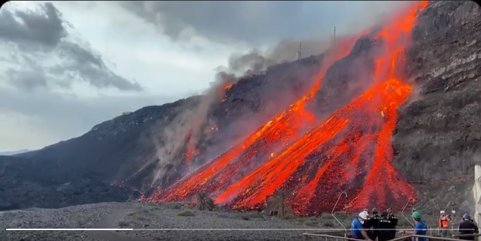
A mesmerizing video footage of the new lava front that overflowed the cliff and reached the Los Guirres beach has been recorded today.
The video below depicts glowing lava falls entering the existing older sea delta after the new lava flow detached from the southwestern margin today.
![]()
Nov 10, 2021
![]()
Nov 10, 2021
![]()
Nov 10, 2021
![]()
Nov 10, 2021
spacer
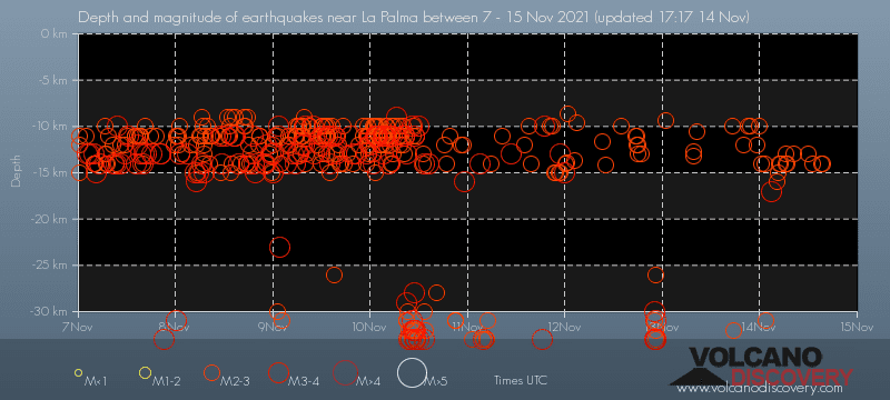
I think this could be the reason that they stopped publishing the maps of the deflation and inflation on the island. I can’t find current ones anywhere. They have been corrupting the data on the Earthquakes. There is no way for us to know what is going on when we can’t get information.
![]()
Nov 9, 2021
spacer
spacer
![]()
Nov 9, 2021
spacer
![]()
spacer

spacer
UPDATE: 11/09/2021; 4:46:11 PM
spacer

spacer
![]()

spacer
![]()
Started streaming 3 hours ago; 11/09/2021; 12:54:19 PM US Central Time
spacer
![]()
Nov 9, 2021
spacer
![]()
Nov 9, 2021
spacer

spacer
Nov 9, 2021
spacer
spacer
UPDATE: 11/09/2021; 1:08:35 PM
spacer
Incredible👇🏻!!!
On #LaPalma 🌋
Footage from @RTVCes. https://t.co/pLBqvYODfY pic.twitter.com/5NRjdDRxRh— 🎯𝓻𝓪𝓬𝓵𝓮 (@LetUsUniteHere) November 9, 2021
spacer

spacer
spacer
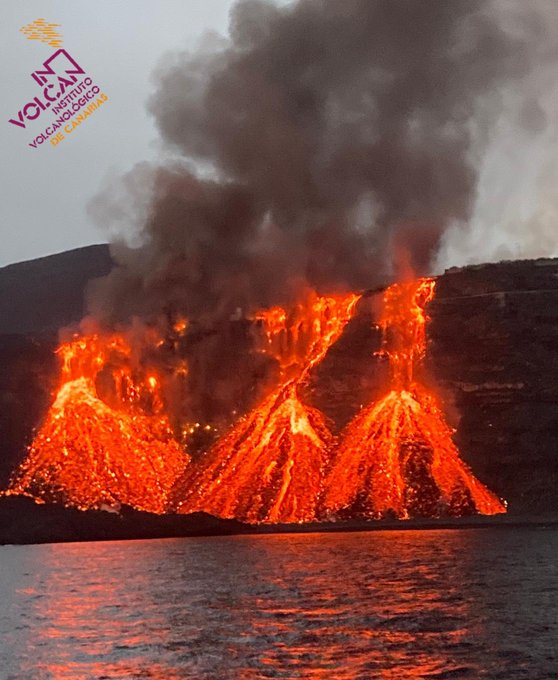
As the lava flows off the cliff toward the beach, it seems to at first form a Trident of three fingers, and then as more lava flows down a pyramid forms. Three pyramids in the video above. Click the link to watch it.

spacer
18
spacer
spacer
![]()
Nov 5, 2021
spacer
![]()
spacer
UPDATE: 11/09/2021; 11:52:37 AM
spacer
![]()
Nov 9, 2021
spacer
Scientists are concerned about lava meeting the sea because toxic gases may be released into the air.
When lava comes into contact with ocean water, it produces a gas plume known as laze.
Laze forms through a series of chemical reactions as hot lava boils the colder sea water.
“It creates a steam of hydrochloric acid, water vapour and bits of ash,” science journalist and volcanologist Dr Robin George Andrews said. “Obviously, it’s not good to breathe in.”
Laze plumes can cause eye, lung and skin irritation but should not be a problem if residents keep their distance, he said.
There is nothing anyone can do to stop the lava flowing into the sea, but as a precaution marine authorities have put in place an exclusion zone of two nautical miles (3.7km) at sea, in the area where the lava is heading.
They hope this will stop the gases from affecting people if they get too close.
Lava from Kīlauea continues to flow into the sea at East Kupapa`u and Kamoamoa. The steam plumes that usually rise from these ocean-entry points do not surprise visitors; it seems reasonable that incandescent lavaat a temperature of about 1,150 degrees Celsius (2,100 degrees F) would cause seawater to boil.
Sometimes, however, streams of lava pour into the sea with little or no steam, as if the lava were not hot at all. How can this be?
From experiments and from observations in Hawai`i and at other volcanoes, scientists have found that the outcome of lava-water interaction is determined by the way the interaction occurs. In order for a volume of seawater to boil, lava must heat it to at least 100.64 degrees Celsius (213.15 degrees F) at the sea surface, and to even higher temperatures below the surface. Obviously, there’s a lot more water than incandescent lava, so if the heat is transferred slowly from lava to seawater, heated water mixes with cooler water, and the boiling point is not reached.
Circumstances that enhance the rate at which heat is transferred to near shore water will favor steam formation. Since heat is exchanged at the interface between lava and seawater, processes that increase the surface area of lava exposed to seawater increase steam formation. High lava-flow rates produce more heated surface area. When an active bench collapses, large surfaces of hot material are suddenly exposed to seawater.
Processes that subdivide lava into smaller pieces can dramatically increase the surface area. For example, a mass of lava the size of a basketball broken into fragments 1 mm (0.04 inches) across increases in surface area by 250 times.
Circumstances that reduce or prevent mixing of heated water with cooler water also enhance steam production.
Thin streams of lava that enter the sea quiescently do so because they are not delivering heat to the near-shore waters rapidly enough to overcome the cooling effects of mixing.
The persistent steam plumes at the East Kupapa`u and Kamoamoa entries form where lava tubes empty at the bench margins. Some of this lava solidifies and extends the bench, and some flows onto black sand beaches. When the surf splashes onto hot surfaces, the thin layer of water is quickly heated to the boiling point, contributing to the steam plume. The surf disrupts some of the molten lava, breaking it into smaller blobs. Quenched by water, the blobs are broken into even smaller pieces. The resultant increase in surface area promotes rapid heating of water. The volume of water available for mixing in the surf zone is less than that available in deeper water. Consequently, heat is delivered to the surf zone rapidly enough to generate steam.
Although relatively benign plumes are the norm where lava meets the sea, explosions of varying magnitude sometimes occur. The most violent explosions take place when part of an active bench collapses into deeper water. The collapse suddenly exposes large surface areas of hot lava to seawater; old and new lava, both solid and liquid, are usually involved.
Large volumes of water suddenly flash to steam, which propels lava fragments in all directions; large fragments have been known to travel hundreds of meters (yards) inland. Lava tubes feeding the edge of the bench can be flooded by seawater, sending jets of ash and steam skyward.
Bench collapses and the resultant explosions can be lethal. To avoid becoming a fatality, heed all of the warnings and signs limiting access to benches. Volcano Activity Update
Eruptive activity of Kīlauea Volcano continued unabated at the Pu`u `O`o vent during the past week. Lavamoves away from the vent toward the ocean in a network of tubes and descends Pulama pali in several separate tubes. Surface flows are observed above the pali and at various places along the trace of the Kamoamoa and Kupapa`u tube systems. Lava continues to enter the ocean in two locations: Kamoamoa and the area east of Kupapa`u.
As mentioned in the article above, the benches of the ocean entries are very hazardous, with possible collapses of the unstable new land. The steam clouds are extremely hot, highly acidic, and laced with glass particles. Swimming at the black sand beaches of the benches can be a blistering or even deadly venture.
There were no earthquakes reported felt during the week ending on November 29.
spacer
Premiered 50 minutes ago; 11:22:46 AM
UPDATE: 11/09/2021; 10:49:04 AM
spacer
spacer
spacer
spacer
spacer
![]()
Light mag. 3.6 earthquake – La Palma Island, 14 km southeast of Los Llanos de Aridane, Spain, on Tuesday, Nov 9, 2021 1:33 am (GMT +0) – 15 hours ago
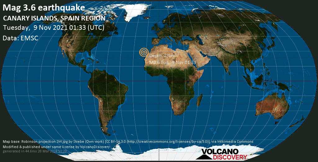
Light magnitude 3.6 earthquake at 23 km depth
9 Nov 01:38: Magnitude recalculated from 4.2 to 3.9.
9 Nov 03:31: Magnitude recalculated from 3.7 to 3.6. Hypocenter depth recalculated from 13.0 to 23.0 km (from 8.1 to 14.3 mi). Epicenter location corrected by 8.2 km (5.1 mi) towards NE.
Date & time: Nov 9, 2021 01:33:00 UTC – 15 hours ago
Local time at epicenter: Tuesday, Nov 9, 2021 1:33 am (GMT +0)
Magnitude: 3.6
Depth: 23.0 km
Epicenter latitude / longitude: 28.6°N / 17.76°W↗ ![]() (Tenerife, Canary Islands, Spain)
(Tenerife, Canary Islands, Spain)
Antipode: 28.6°S / 162.24°E↗
Nearest volcano: La Palma (3 km / 2 mi)
Nearby towns and cities:
2 km (1 mi) ESE of Mazo (pop: 4,810) –> See nearby quakes!
9 km (6 mi) S of Santa Cruz de La Palma (La Palma Island) (pop: 17,100) –> See nearby quakes!
15 km (9 mi) NE of Fuencaliente de la Palma (La Palma Island) (pop: 1,890) –> See nearby quakes!
17 km (10 mi) ESE of Los Llanos de Aridane (La Palma Island) (pop: 20,800) –> See nearby quakes!
20 km (12 mi) S of Garachico (Santa Cruz de Tenerife, Kanarische Inseln) (pop: 6,000) –> See nearby quakes!
29 km (18 mi) SE of Santo Domingo (pop: 1,930) –> See nearby quakes!
119 km (74 mi) WNW of Arona (pop: 78,600) –> See nearby quakes!
141 km (88 mi) W of San Cristobal de La Laguna (pop: 150,700) –> See nearby quakes!
148 km (92 mi) W of Tenerife (pop: 222,400) –> See nearby quakes!
236 km (147 mi) WNW of Las Palmas de Gran Canaria (pop: 381,800) –> See nearby quakes!
Scattered Clouds
 8.5°C (47 F), humidity: 64%, wind: 5 m/s (10 kts) from NNW
Primary data source: EMSC (European-Mediterranean Seismological Centre)
Estimated released energy: 1.6 x 10¹⁰ joules (4.4 megawatt hours, equivalent to 3.79 tons of TNT) More info


If you did NOT feel the quake although you were in the area, please report it! Your contribution is valuable to earthquake science, seismic hazard analysis and mitigation efforts. You can use your device location or the map to indicate where you were during the earthquake. Thank you!
Data for the same earthquake reported by different agencies
| Mag. | Depth | Location | Source |
| 3.7 | 13 km | Spain: SW VILLA DE MAZO.ILP | IGN |
| 3.6 | 23 km | CANARY ISLANDS, SPAIN REGION | EMSC |
spacer
La Palma, Canary Islands: eruption Sep 2021 – updates
Activity continues to slow down
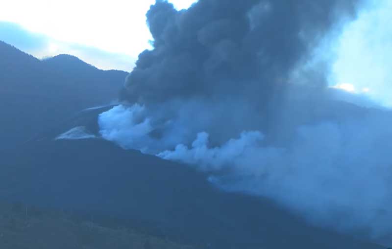

The activity at the vents continues to decrease gradually, at least visually and audibly. Residents reported less explosions and less intense degassing noises. Explosions at the vent are intermittent and no longer as vigorous as before although ash emissions seemed to have picked up in the morning again.
On the webcam, it can be seen that lava emission continues, but also seems less vigorous. Some of it forms active lava flows on the lower flanks of the cone, overlapping older flows.
Volcanic tremor has remained at similar levels as yesterday, but continued to decrease overall. Hopes are emerging that the eruption might be approaching an end although this is still too early to be certain of.
A pair of two quakes with magnitudes 4.5 and 4.6 occurred last afternoon at 5.07 p.m. at approx. 38 depth within 10 seconds from each other, but so far, there seems not to be any significant change with other parameters (e.g. eruption intensity) that clearly correlates.
It is not known what the exact significance of these and other quakes is at the moment. Whether it is caused by an injection of new magma at depth, or gravitational adjustments perhaps caused by the depletion of magma from there or something else, is speculation. It might become clearer in the future (likely some time after the eruption ends), when the data currently collected by scientists will be more complete and when models will be made that can match the various data with the observations. For now, one can just wait and see…
spacer
UPDATE: 11/08/2021; 5:22:47 PM
Of course we all know, or should know, that Gateways and Portals are very powerful and significant in the Spiritual Realm. The imagery around the Travis Scott AstroWorld Consert is chuck full of messages and symbols regarding portals, and transitioning from One world to Another. Traveling on the ASTRO plane.
I found it very interesting that today, the 8th day of month, a post was put up online of an ARCHWAY Bridge in La Palma. The LONGEST ARCHWAY Bridge in Spain.
![]()
Nov 8, 2021
You should be aware that ARCHES are also portals. It made me think of one of the promotional posters for the concert.
Here is the poster:
 spacer
There is a great deal of imagery related no only to the Illuminati plan for order out of chaos, there are demons coming up out of the pit, there is the imagery of a MAIN Demonic Force controlling it all and most important in relation to this post is the imagery related to the Volcano. Possibly, the La Palma volcano, being the point of entry for all this.
Here are just a few of the images, enough to give you the idea.
spacer


spacer
UPDATE: 11/08/2021; 5:26:29 AM
spacer
 Installation work of a thermal and visual camera on the east flank of #VolcanDeLaPalma with the help of the (thanks Cecilio). Photos by Iván Torres. #IGNSpain #ErupcionLaPalma
|
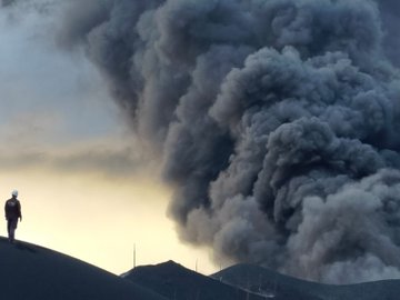
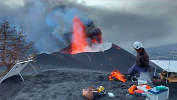

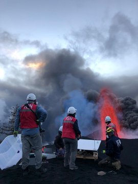
spacer
Vídeo de la erupción a las 10.30 (hora canaria) desde los alrededores del Mirador Astronómico del Llano del Jable /Video of the eruption at 10.30 am (Canarian time) from the surroundings of the Llano del Jable Astronomical Viewpoint pic.twitter.com/dAwiLjZ4Tq
— INVOLCAN (@involcan) November 8, 2021
spacer
Primeras imágenes de hoy de la erupción desde el embalse Dos Pinos (Los Llanos) a las 8.30 (hora canaria) / First images of the eruption today from the Dos Pinos dam (Los Llanos) ar 8.30 (Canarian time) #LaPalma pic.twitter.com/q4vdtJ5coS
— INVOLCAN (@involcan) November 8, 2021
spacer
Confirmation that there truly were TWO Quakes at 5:07 yesterday that were both over 4.0.
![]()
Updated: Mon, Nov 8, 2021 08:51 GMT – 2 hours 11 minutes ago
| Nov 7, 2021 5:07 pm (GMT +0) (Nov 7, 2021 17:07 GMT) 18 hours ago |
4.5
38 km |
La Palma Island, 30 km south of Los Llanos de Aridane, Spain I FELT IT – 64 reports |
| Nov 7, 2021 5:07 pm (GMT +0) (Nov 7, 2021 17:07 GMT) 18 hours ago |
4.6
37 km |
La Palma Island, 14 km southeast of Los Llanos de Aridane, Spain I FELT IT – 1 report |
spacer
UPDATE: 11/08/2021; 4:02:15 PM
![]()
Nov 8, 2021
La Palma, Canary Islands: eruption Sep 2021 – updates
Activity continues to slow down
The activity at the vents continues to decrease gradually, at least visually and audibly. Residents reported less explosions and less intense degassing noises. Explosions at the vent are intermittent and no longer as vigorous as before although ash emissions seemed to have picked up in the morning again.
On the webcam, it can be seen that lava emission continues, but also seems less vigorous. Some of it forms active lava flows on the lower flanks of the cone, overlapping older flows.
Volcanic tremor has remained at similar levels as yesterday, but continued to decrease overall. Hopes are emerging that the eruption might be approaching an end although this is still too early to be certain of.
A pair of two quakes with magnitudes 4.5 and 4.6 occurred last afternoon at 5.07 p.m. at approx. 38 depth within 10 seconds from each other, but so far, there seems not to be any significant change with other parameters (e.g. eruption intensity) that clearly correlates.
It is not known what the exact significance of these and other quakes is at the moment. Whether it is caused by an injection of new magma at depth, or gravitational adjustments perhaps caused by the depletion of magma from there or something else, is speculation. It might become clearer in the future (likely some time after the eruption ends), when the data currently collected by scientists will be more complete and when models will be made that can match the various data with the observations. For now, one can just wait and see…
spacer
![]()
Nov 8, 2021
spacer
spacer
UPDATE: 11/08/2021; 12:42:10 PM
THERE ARE MANY, MANY PEOPLE in La Palma who have lost EVERYTHING!! They will not benefit from your tourism. Their businesses, homes, vehicles, farms, ARE GONE!! If you want to help the people of La Palma, send help!! Support the LOCAL PEOPLE who are ministering to other LOCAL PEOPLE. Send whatever you can. This situation is not going to improve at all for weeks to come and may escalate into something much more devastating. PRAY for these folks.
Here are some replies to a TOURISM POST that won’t even post here. I want you to hear what these folks had to say..
spacer
#LaPalma Today. pic.twitter.com/XXlHOoTqpv
— 🎯𝓻𝓪𝓬𝓵𝓮 (@LetUsUniteHere) November 8, 2021
spacer
Nov 8, 2021; less than an hour ago; 11:27 US CENTRAL TIME
spacer
![]()
Nov 8, 2021; 5 hours ago
spacer
Nuestros colegas italianos del @INGVvulcani han estimado la altura mínima del penacho hoy en 1600 metros / Our Italian colleagues from @INGVvulcani have estimated the minimum height of the plume today in 1600 meters pic.twitter.com/e7d677rog7
— INVOLCAN (@involcan) November 8, 2021
spacer
|
Fotografías de la #ErupcionLaPalma tomadas este mediodía / Photograms of the #LaPalmaEruption taken this noon #LaPalma
|

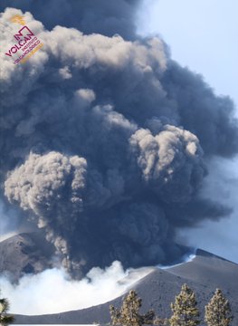
spacer
Nov 8, 2021; 6 hours ago
spacer
![]()
Nov 8, 2021
spacer
News – The explosiveness of the volcano throws more uncertainty about its end
English: It is the new explosive episode at Cumbre Vieja after several days of less eruptive intensity. The volcano has again expelled a large amount of lava. Overflows are not ruled out, although the new incandescent material passes through the courses of the central flows without covering more of the island. The control of the flows is continuous. Its progress, temperature, composition and the expulsion of harmful gases are studied. The seismic swarm has also increased, with 18 earthquakes detected in the last hours. One of them of magnitude 4.5 in Fuencaliente, 36 kilometers deep. But what worries the most is air quality, which continues to be extremely unfavorable in the municipalities of Tazacorte, Los Llanos de Aridane, El Paso, Tijarafe and Puntagorda, due to the concentration of microparticles in the air. It is recommended to reduce outdoor activity to the general population and avoid it to risk groups. (Source: Atlas) Málaga 24 horas noticias live TV en vivo televisión española gratis Noticias en directo de el Mundo, última hora, España, Andalucía, y Málaga. Emisión Online gratis Directo de Málaga 24 Horas noticias. Tu canal de noticias en TDT e internet y operadores de fibra optica
Spacer
spacer
UPDATE: 11/11/2021; 1:06:16 PM