RESTORED 5/13/26
The ARCTIC BLAST that is coming for the holidays has been named ELLIOT. Be warned folks this storm is no JOKE! It is not going to calm down or go away. It could end up being far worse than they are predicting which is unimaginable! The current predictions are pretty dark. Freezing temperatures across most of the Nation. They can’t even guess yet where the snow is going to hit or who will get the worst of it in the form of a BLIZZARD. There is no way to foretell what areas may receive hail or worse yet freezing rain and heavy ice accumulation.
Personally, I suspect this was created deliberately. But, that is just my opinion. No matter if it is naturally occurring or geoengineered the impact will be the same.
There are those who say that ELLIOT means “Gift from God” or “Jehovah is GOD” or “Believe in God”…BELIEVE ME OUR PRECIOUS HEAVENLY FATHER has nothing to do with this STORM.
Here is a more factual translation of the name: EL/BAAL/The Bull/Prince of the Power of the AIR is who you are obliged to for this storm.
|
The Dictionary of Deities and Demons in the Bible explains of Baal: “His elevated position shows itself in his power over clouds, storm and lightning, and manifests itself in his thundering voice. As the god of wind and weather Baal dispenses dew, rain, and snow and the attendant fertility of the soil.
|
spacer


Going Deep – Birmingham
COMMONWEALTH GAMES – BIRMINGHAM, ENGLAND
2022 COMMONWEALTH GAMES REVISITED – Too IMPORTANT to MISS!
I have already demonstrated to you repeatedly that the RULING ELITE worship the Ancient Pagan Deities. Do you seriously think they would do that if they did not get something for it??Do you think the ancient people worshiped them just out of the blue? NO, these entities exist. They are SPIRITUAL BEINGS so they are ETERNAL. They do not die. They have been kept away from us by the grace and mercy of GOD. But, foolish humans have been calling them back. NOW, they are here.
They definitely have power. But we know who is in CONTROL. Satan is the Prince of the Power of the Air and he will be allowed to use his power for a time, a set time period.
All those rituals they perform at sporting events like the Super Bowl, Olympics and Commonwealth Games; all the Awards they hand out; all the Television Programming and Commercial Advertisements; all contain symbolism and ritual rites for a purpose. They have been gaining power over the years and that is why we are in the mess in which we find ourselves.
spacer
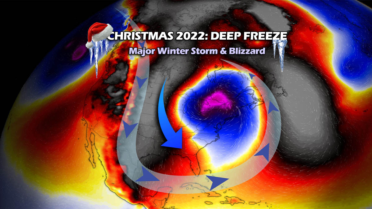
Millions across North America will face Deep Freeze and the Coldest Christmas in Years as Powerful Winter Storm Elliot With Snow and Blizzards Heads for the East-Central United States This Week
Christmas Holidays this year will be one to remember. A powerful Arctic cold blast is forecast to plunge from Canada into the United States under the Polar Vortex lobe aloft mid-week. It will lead to a major winter storm named Elliot, rapidly developing over the Great Lakes and Northeast U.S. Bitterly cold will send 100+ million across the eastern two-thirds of the country into a deep freeze. While a so-called bombogenesis cyclone will blanket Midwest, Great Lakes, and Northeast with deep snow and intense blizzards.
Weather models are well-aligned for the new winter storm coming up late this holiday week. A powerful storm Elliot will bring heavy snow and blizzards, causing travel disruptions with icy roads, low visibility, and deep freeze rapidly spreading behind the Arctic front.
Pre-Christmas days will bring the coldest air of the Winter season 2022/23, which officially begins on Wednesday. Very strong winds will bring windchills extremely low. Close to -60 degrees F across the north. With more than a hundred million Americans on the move around Christmas yearly, Elliot will become the real deal for travelers battling extreme weather.
A major winter storm is the first forecast to develop into Midwest Wednesday night, with significant pressure and temperature difference across the Plains. As the polar air mass moves across the Rockies, a surface low will deepen on the Lee side of the mountains. Leading to a sharp temperature gradient along the fast-moving Arctic front.
A frigid cold air mass reservoir has been accumulating across the Canadian plains early this week, with its southern fridge already nosing across the international border into Montana and Dakotas. Windchill, the real feel temperature, has been into close t -50s F on Tuesday morning across the far north.
Into mid-week, the lobe of the Polar Vortex above will shift south, releasing a serious deal for the United States to begin. The general weather pattern becomes more meridional, with north-northwesterly flow establishing aloft.
This will send much colder weather and extremely low windchills across a large part of the United States, already reaching far south to Central Gulf Coast by late Thursday and Florida by Friday morning. Christmas holidays weekend will be bitterly cold this year, with much colder than average temperatures forecast to persist into next week, at least for the Eastern U.S.
Along the accelerating Arctic blast front-end, a surface low will rapidly deepen on Thursday. Resulting in heavy snow across the Midwest, from Kansas, Missouri, and Iowa to Illinois, Indiana, and Michigan to be hit by the worst conditions. High winds will bring near-zero visibility and impassable roads and blast St. Louis, Chicago, and Detroit with massive blizzards.
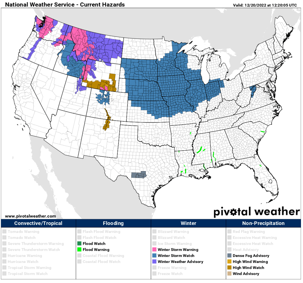
A large part of the Midwest is already under the Winter Storm Watch as alerts, including weather watches and advisories, have already been issued by the National Weather Service (NWS) as of Monday night.
The pressure change will reach explosive drops through Thursday night, often found with the most intense mid-latitude cyclones. These events are known as bomb cyclones, or the process itself is called bombogenesis. We will discuss its evolution in detail further down.
This is also why the cold is forecast to be so particularly strong and makes progress far south across the nation. Coinciding with the intense cold of the vortex lobe above, the polar air mass will send more than a hundred million people into a deep freeze, with temperatures forecast to fall into single digits quickly within a few hours.
The above video gif-animation forecast reveals the impressive spread of the Arctic front and bitterly cold air mass from central Canada deep south into the United States this week before the Christmas holidays. The development of an explosive bomb cyclone is visible as it grazes across the Midwest into Great Lakes and Northeast U.S.
As mentioned earlier, the Polar Vortex circulation aloft is very powerful as winter starts. Recently, one of the coldest parts of the core sits above Arctic Canada. This part is known as the southern lobe and will be responsible for the upcoming arctic freeze towards the United States.
The Polar Vortex feature plays an important role during winter, often sending very deep upper troughs with significant cold outbreaks and snowstorms across the North American and European continents. Let’s look into some basic details to understand its effects on our weather better.
WHAT IS THE POLAR VORTEX?
As we know, Earth’s atmosphere has several layers rounding our planet. Most of the weather dynamics on our planet occur in the lowest two layers, the troposphere and the stratosphere above it.
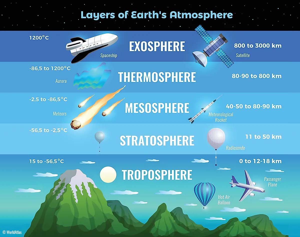
The troposphere layer is the lowest one; all the weather changes take place here. The troposphere layer extends from the Earth’s surface (or the sea level), high up into the sky to 12 km altitude. The troposphere’s depth varies from 8 km to nearly 20 km. It is the deepest above the equator and gets thicker above both poles.
Above this layer, we have a much deeper one, known as the stratosphere. A stratosphere layer is about 11-50 km thick and very dry. The Ozone layer, vital in protecting our planet, is also found in the stratosphere.

So, our general weather behavior has one vital feature in the stratosphere for all its dynamics. It is the Polar Vortex. The Polar Vortex is an enormous, three-dimensional ring of very strong winds. It is located about 20-50 km above the Earth’s surface. Earth has two, one surrounds the North, and another is above the South pole. Both are the strongest during the local winter.
The troposphere and the stratosphere layers are crucial for Earth’s climate because the Polar Vortex covers most of the bottom half of the atmosphere. Thus, from the Earth’s troposphere up into the stratosphere. So it has an important role in the winter weather across the high and mid-latitudes.

Despite the vortex spinning high above our troposphere, it is still directly connected to the lowest part of the atmosphere where we live. The Polar Vortex shapes our daily weather in many ways. As it works as one large hemispheric circulation.
But how does it form?
The Polar Vortex generally has seasonal differences and is the strongest during the winter, as we learned. When the calendar turns into the autumn months, the polar regions receive much less sunlight over time due to the inclination of the Earth’s axis. This sends the north pole into a position where it starts cooling down fast.
While the poles are getting cooler with time, the atmosphere further south remains quite warm. The southern layers receive much more sunlight and energy from the Sun than the polar regions.
The temperatures falling over the polar regions also lower the ambient surface pressure. A very similar process occurs in the stratosphere layer above. Thus, the temperature difference between the North pole and the equatorial region increases. A large low-pressure (cyclonic) circulation develops across the polar stratosphere.
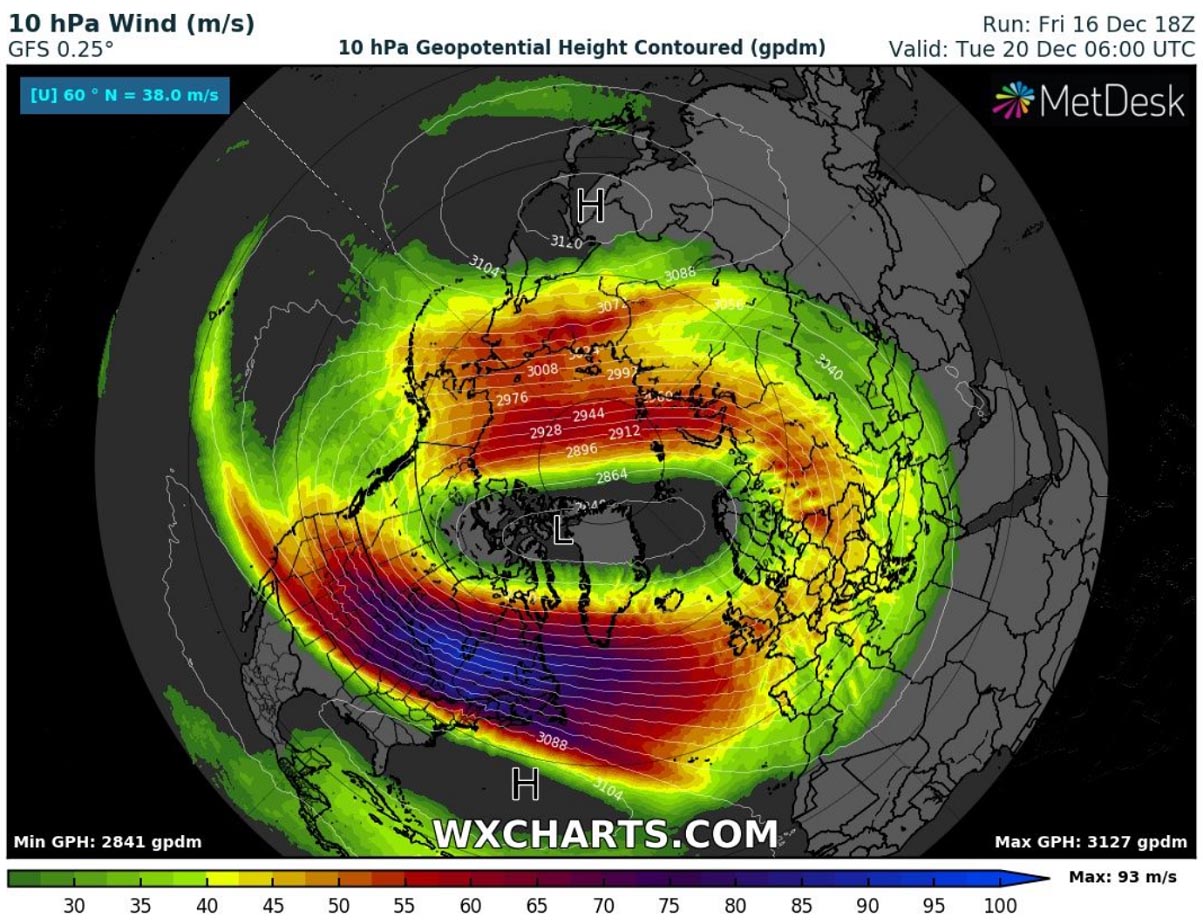
This chart above indicates a typical example of the Polar Vortex set at around 30 km (18 miles) altitude during the winter. It represents the powerful jet stream rounding the vortex core inside. When we discuss its behavior, we generally look at 10 mbar level charts.
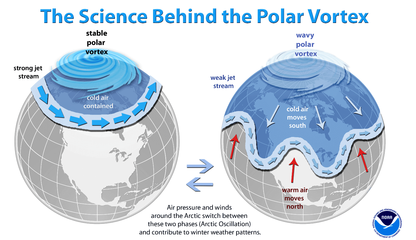
With these details learned, we can put all of them together to a conclusion; The Polar Vortex is a very large cyclone, covering the whole north pole. Occasionally, its lobes turn south towards mid-latitudes since the polar front is a very dynamic feature. It strongly depends on the intensity of the vortex itself.
SOUTHERN LOBE OF THE POLAR VORTEX RELEASES AND EXTREMELY COLD ARCTIC BLAST INTO NORTH AMERICA
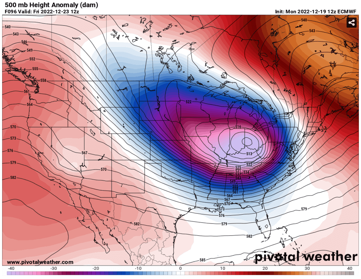
The developing weather situation across North America will form a well-pronounced dipole weather pattern beneath the front edge of the Polar Vortex lobe aloft. This means that a High over the northern Pacific and western North America has a significantly deeper upper trough/low on its east. This low is plunging from Arctic Canada south into the United States with bitterly cold airmass through days before the Christmas holidays.
The 500 mbar chart below indicates an upper-level low, becoming particularly deep while moving across the States from Thursday night through Friday. It is forecast to drag the air from the upper levels deep towards the surface south throughout the second half of the week into the Christmas weekend.
Typically, a strong high surface pressure system develops beneath the very cold air mass. The surface High will expand across much of west-central Canada and the United States for the rest of this month, persisting for nearly two weeks. A new Winter Storm will develop on the Arctic blast’s edge.
Giving a significant pressure difference between eastern Montana (1056 mbar) against the deep surface cyclone over the Great Lakes (967 mbar). This is an impressive, nearly 90 mbar difference in pressure. Hence, looking at the isobars (lines connection equal pressure) on the chart, one can judge why the pressure gradient will support such severe winds from the north.
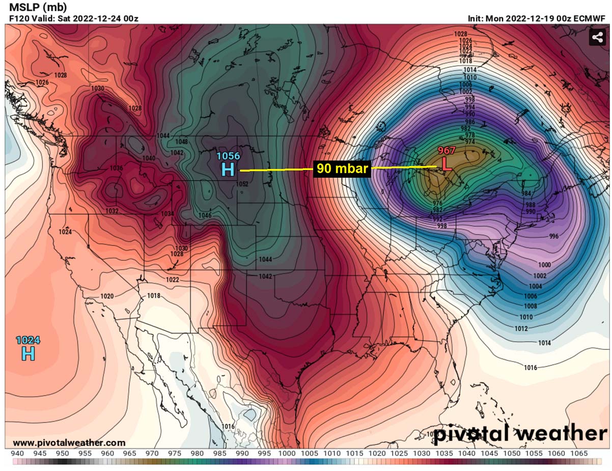
Forecasted surface pressure values across the northern High Plains also challenge some historical values. Montana’s high-pressure, for instance, has the highest pressure record of 1064 mbar. Weather models hint that the surface peak High will be near the record values on Friday.
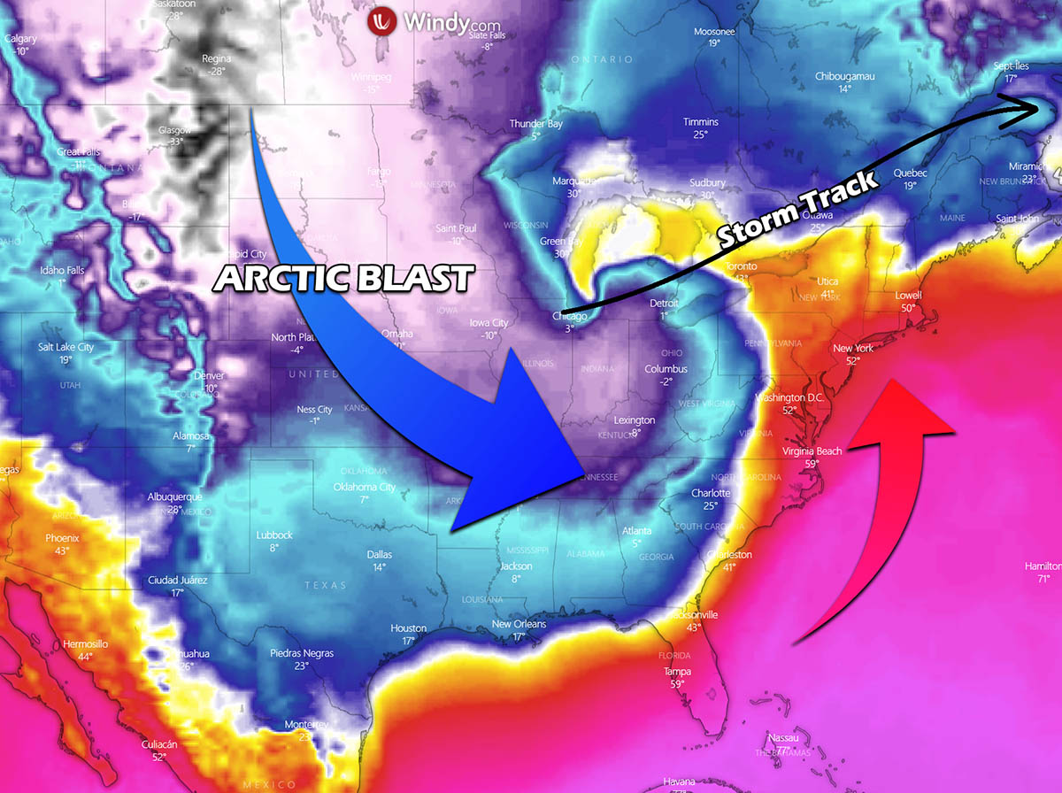
A strong pressure gradient that results in enhanced winds will lead to a massive transport of a frigid Arctic air mass from west-central Canada into the central part of North America. Southern Canada and most of the CONUS will be at the core of this blast from Thursday through Christmas day on Sunday. The general wind flow is forecast to be pure meridional, where winds follow a pressure pattern, blowing from High toward Low.
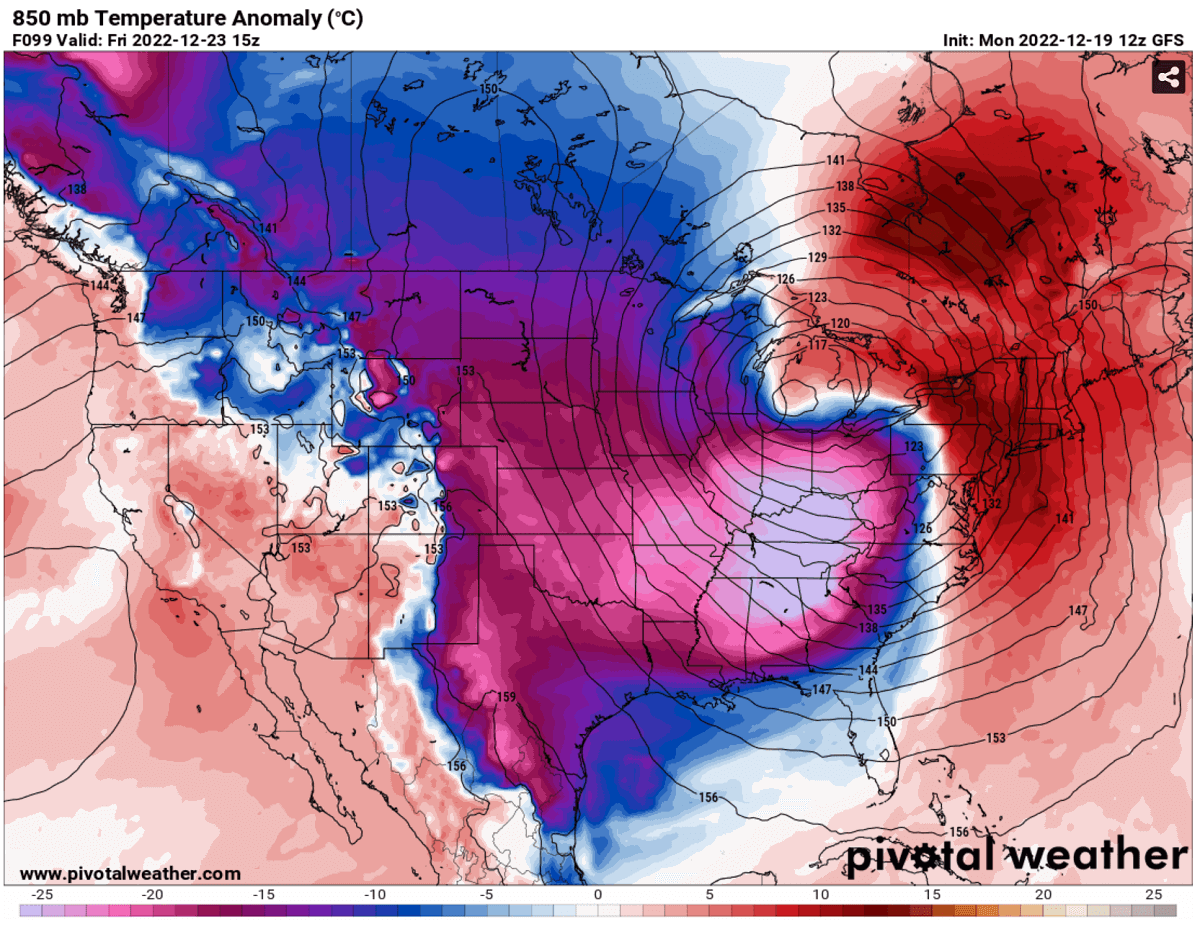
Extremely low temperatures will send the Plains, Midwest, Great Lakes, and Ohio Valley into a deep freeze first, then spread further south and east just before Christmas. Reaching Texas, Gulf Coast, Florida, and East Coast by Friday. The extensive cold pool associated with the new winter storm Elliot will be the coldest winter season in 2022/23. And stretch from Alberta and Saskatchewan, Canada, across the Dakotas, Midwest, Mississippi Valley, and the Gulf coast.
As we discussed earlier, the bitterly cold will be so severe due to the intense winter storm as the pressure will be extremely low. These so-called cyclonic bombs are very fast-developing winter storms, often resulting in significant damage when they hit land areas. When combined with heavy snow, weather havoc evolves.
DEEP COLD HELPS TO DEVELOP AN EXPLOSIVE CYCLONIC BOMB – WINTER STORM ELLIOT
When the primary cold blast spread into the central U.S., the surface low on its front end begins deepening. This process intensifies on Thursday, lowering the surface pressure over Midwest. Farther west, much higher pressure overspreads the northern Rockies and the Plains.
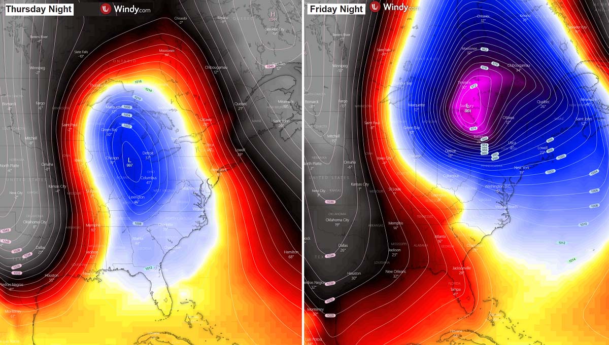
The low explosively deepen from Thursday night into Friday, with a pressure fall of nearly 30 mbar by Friday night. Meaning it will be classified as a bomb cyclone. On the side-by-side chart above, one can see how tight the pressure lines are placed when the winter storm Elliot matures. This will create severe winds combined with heavy snow and blizzards.
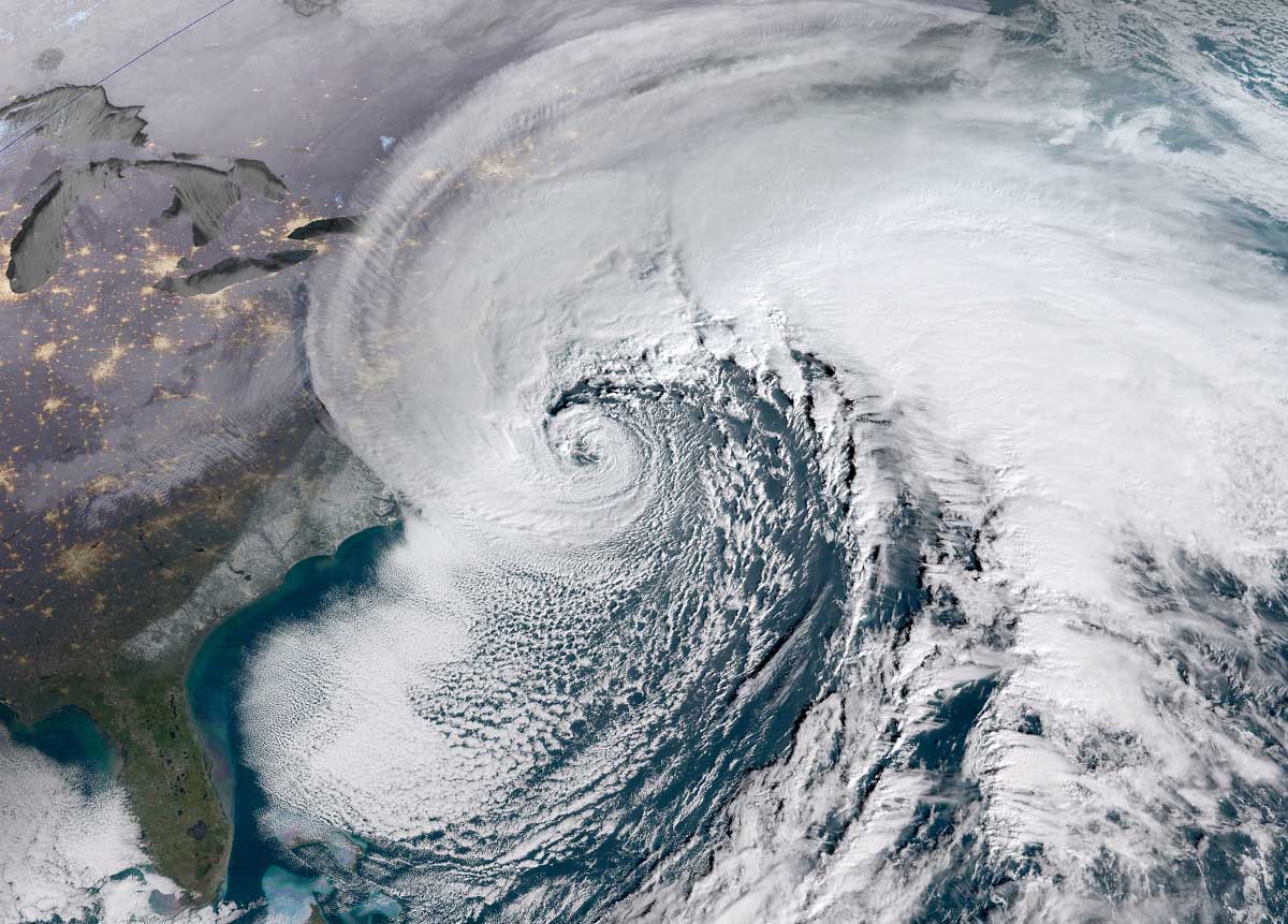
The surface temperature image below reveals how a much colder air wraps around the core of the deep low, centered around Chicago, on Thursday night. This is a very impressive yet textbook example of the developing storm. Strong warm advection ahead of the system spreads towards the Northeast, while an extensive reservoir of Arctic blast is pushed in the cyclone’s wake. The approximate storm track is marked by the black arrow, tracking across the Great Lakes.
The rather typical process of this kind of weather system, storm Elliot will be undergoing a bombogenesis process for nearly 36 hours, starting late Thursday. Reaching its mature stage on Sunday, with central pressure in the 960s over the Great Lakes. We can also expect its structure to look pretty spectacular on satellite imagery when the peak intensity occurs.
To conclude, Winter Storm Elliot will become the deepest bomb cyclone of the cold season in 2022/23. The central pressure could deepen into the mid-960s, becoming particularly intense surface low with severe winds.
Have you ever heard of these cyclones? Why do they have such a striking meteorological name, and why are they so powerful? Their origin and background processes are interesting weather phenomena. Let’s see why.
A BOMB CYCLONE – HOW POWERFUL ARE THESE STORMS?
The mid-latitude region of both the northern and southern hemispheres sometimes develops some very impressive storms. We can’t miss them just by looking at the satellite images. They are very powerful and, meteorologically speaking, also very didactic and outstanding weather systems as their development is very rapid. This means that the central pressure inside these storms is falling very rapidly.
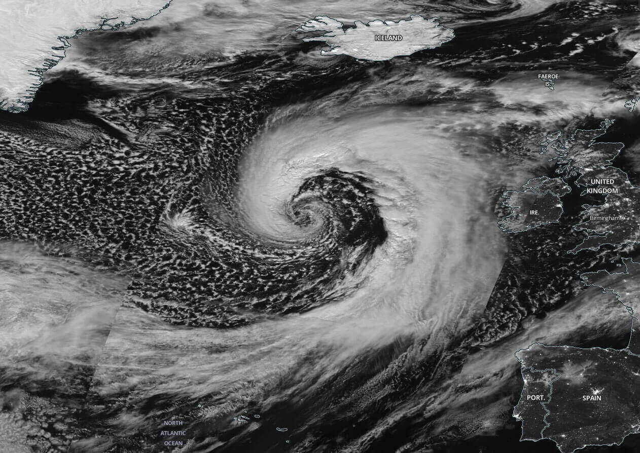
Most will remember the Nor’Easter Quinlan storm off Northeast U.S. in March 2022; it was the perfect example of a bomb cyclone. Its central pressure was extremely deep, around 925 mbar, and was North America’s most intense weather system during the Cold Season 2021/22.
In these large systems, the surface cyclone/low intensifies so fast that its central pressure falls rapidly, often extremely fast. The process behind it is known as bombogenesis, meaning that such a system has explosive cyclogenesis ongoing. Leading to an extremely rapid deepening of its core barometric pressure.
The pressure change this Thursday and Friday will likely meet the criteria for such meteorological classification. A textbook example of a bomb cyclone is seen below, a typical Nor’Easter winter storm along the Northeast U.S. coast.
Technically speaking, a pressure fall of at least 24 millibars within 24 hours is the main criterion the cyclone needs to meet before it can be officially classified as a bomb cyclone. It develops very fast from a typical low-pressure system, usually in a timeframe of 12 to 36 hours.
These storms normally grow very large, dominating a large portion of the continent or the ocean (if it develops over the Atlantic or Pacific). Due to the Coriolis effect, the general movement of these cyclones in the Northern hemisphere is towards the northeast. The cyclone’s size produces intense and extremely severe winds due to a strong pressure gradient. And, combined with snowfall, it results in intense blizzards.
So, similar to the classic extratropical cyclone over the Atlantic, these storms are fueled by variations in the temperature, between the warmer temperatures coming from the south (even subtropical region) and the much colder Arctic temperatures coming from the north. And this process also occurs vertically throughout the atmosphere, where winter cyclones develop from the extremely strong temperature gradient near the two air masses clashing together.
The east coasts of the North American continent and Northwest Atlantic coasts are the perfect breeding grounds for these types of cyclones cyclonic during the late fall and winter months. Still, sometimes they also develop farther west inland, as happens this Christmas week. The interaction of the Arctic cold continental air mass and warmer, moist, and warmer air mass provides energy for systems to develop rapidly.
The statistical satellite data reveals about 60-70 cyclone-type formations annually on Earth. About two-thirds of them occur in the Northern Hemisphere, particularly along and off the East Coasts of the U.S. and the North Atlantic. This region is where the best interaction of the Arctic and subtropical air masses meets more often.
WINTER STORM ELLIOT WILL SEND A HUNDRED MILLION PEOPLE INTO DEEP FREEZE AFTER THURSDAY, WITH WINDCHILLS BELOW -50 °F
With strengthening pressure associated with the Winter Storm on the north, the Arctic front will begin its plunge down the Front Range of the Rockies in Colorado and Wyoming on Wednesday, spreading through the central Plains.
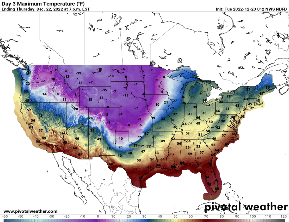
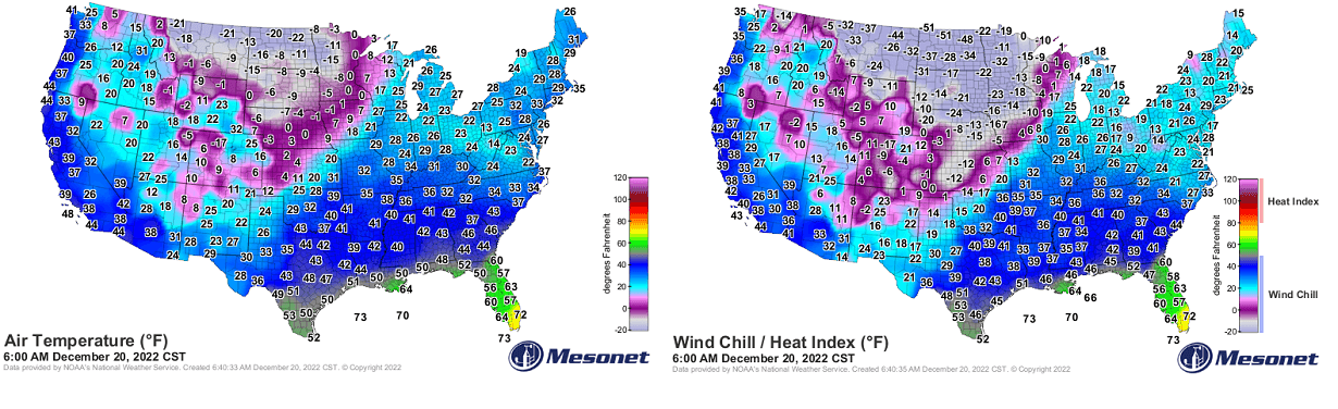
Daytime temperatures are forecast to stay below -10 °F across the North on Thursday, with Montana, Wyoming and Dakotas hit the worst. Bitterly cold winds keep the real feel much lower, from -40 to -60 °F on Thursday and Friday. Farther south and east on Thursday, the afternoon temperatures across the Midwest will stay between -10 °F and 0 degrees.
On Thursday, the bitterly cold air mass will rapidly nosedive temperatures across the south-central Plains. Combined with severe winds, spreading to the rest of the Southeast and Florida into Friday.

The cold will rapidly spread towards the south-southeast through Friday, reaching the Missisippi Valley and the Gulf coast by the morning. Friday will bring nearly two-thirds of the country staying below freezing all day. The worst cold, with daytime Highs in the negative F, will stay across the Dakotas and Upper Midwest.
Strong northerly winds beginning early Wednesday will bring extremely low wind chills across the Plains. Real feel temperatures will be below -30 °F, much lower, around -50 °F across the north (Montana, Dakotas).

These real feel temperatures are extremely low, with a high risk of frostbites for those exposed outside.
Mornings on Thursday and Friday will bring extreme cold for most Lower 48, with below-freezing in deep south Texas and central Florida.

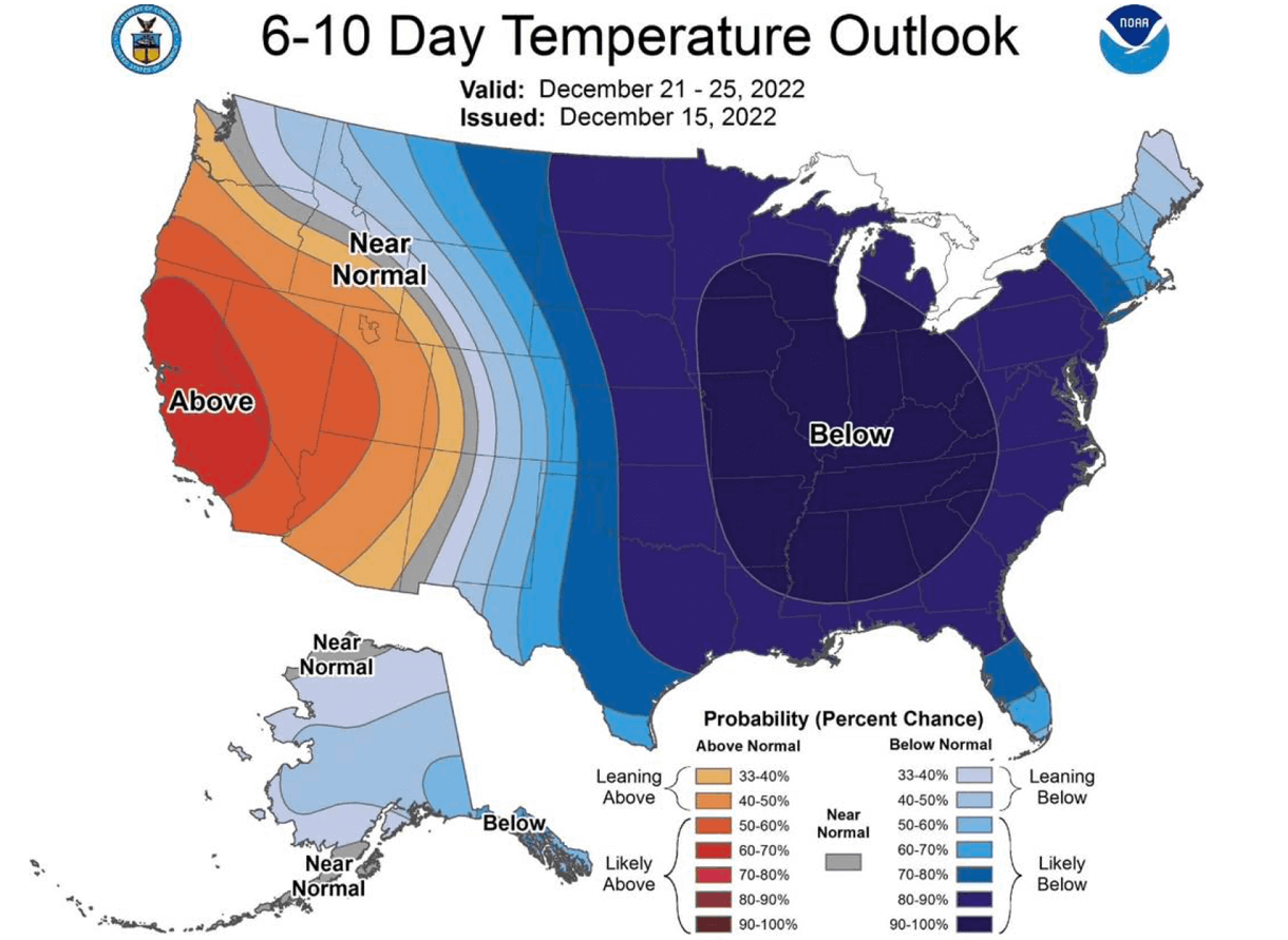
With the winter storm and time progressing into the Christmas weekend, the cold will maintain across a large portion of the U.S., with nearly 200 million affected by the extreme cold. The strongest cold will sit over the Southeast Friday night into Saturday.
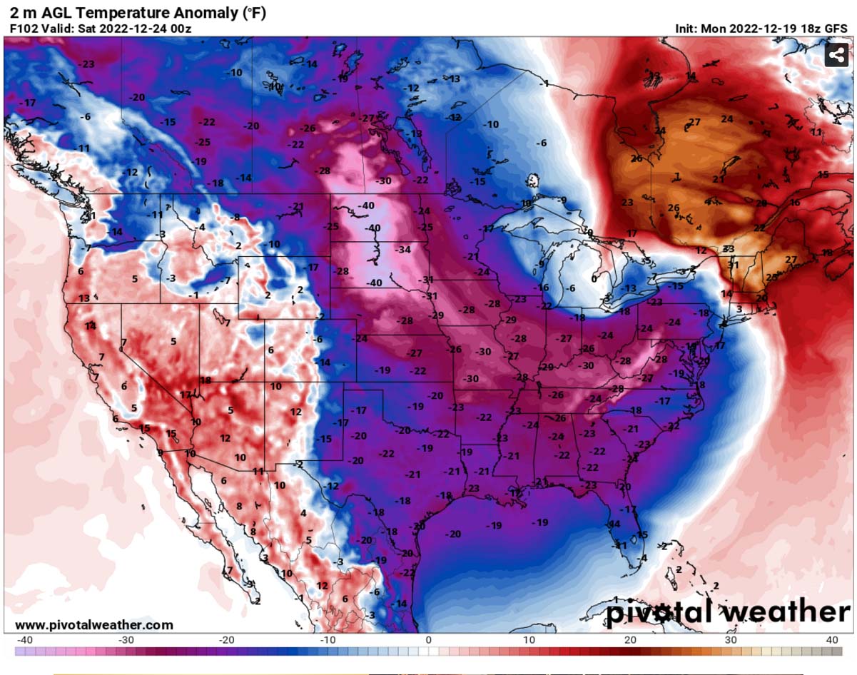
Christmas Day will remain very cold for the eastern half of the States, being the coldest holiday weekend in years. Meanwhile, warming returns into the West and Pacific Northwest.
MASSIVE SNOW AMOUNT FORECAST ALONG THE TRACK OF WINTER STORM, BLIZZARDS TO DISRUPT TRAVELS
How deep snow amount will blanket the Midwest and the Great Lakes, possibly also parts of Ohio Valley, strongly depends on the exact track of the winter storm Elliot’s core. As the process of these explosive systems is very fast and dynamic, weather models have serious issues handling the best detail on the precipitation amount.
The attached ECMWF weather model forecast for the total snow amount until Christmas Eve hints that most snow is likely across the Midwest, Upper Midwest, and Great Lakes.
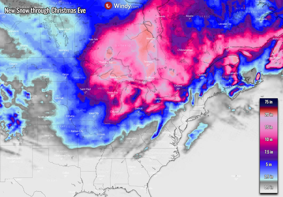
The snow amounts vary, but the Elliot storm can dump over a foot of snow in a large area around the low’s center and to its immediate north. With the highest potential for the thickest snow blanket over the western Great Lakes, from Wisconsin and northern Illinois to Michigan and northern Indiana on the other side of the swath.
As northerly winds will be particularly intense within the tight pressure gradient, areas to the south-southeast of the Lakes could potentially see a dramatic increase in snow depth, and Polar air mass should also help to develop lake-effect snow.
As mentioned above, the intense pressure difference will also significantly increase the winds. Thus, the strongest winds are forecast from Thursday night through Friday until early Saturday when the Winter Storm matures.
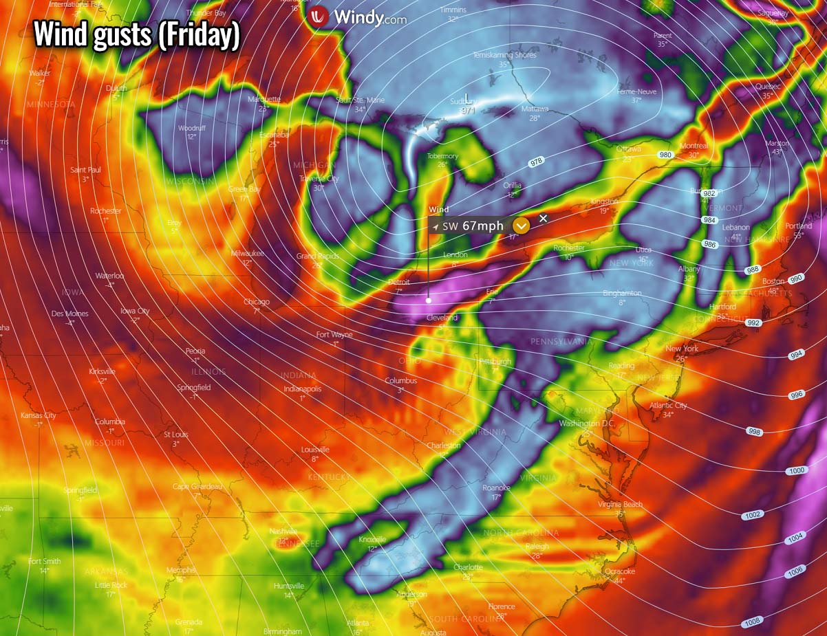
With sustained winds of around 50 mph, peak gusts up to near 70 mph are well possible in some areas. Blowing snow and blizzards will be intense, significantly reducing visibility to near zero. Disrupting travels and causing delays. Road closures are also very likely to follow, especially where the most intense winds and snowfall combine.
Stay safe and follow warnings from your local weather service for the nowcasting information on the developing storm. We will update you further before the main impact, extreme cold, and blizzards.
Images used in this article were provided by Windy, Pivotalweather and Wxcharts.
Comments are closed.