Firefighters are battling a brush fire that is dangerously close to homes in the Pacific Palisades section of Los Angeles. Details: https://abc7.la/31AnsYz
Officials provided an update on the Kincade Fire in California on Saturday night, warning residents to evacuate if they were placed under an evacuation order.
A fast-moving wildfire prompted mandatory evacuations in the greater Los Angeles area on Oct. 11. Read more: https://wapo.st/33m8mqH. Subscribe to The Washington Post on YouTube: https://wapo.st/2QOdcqK
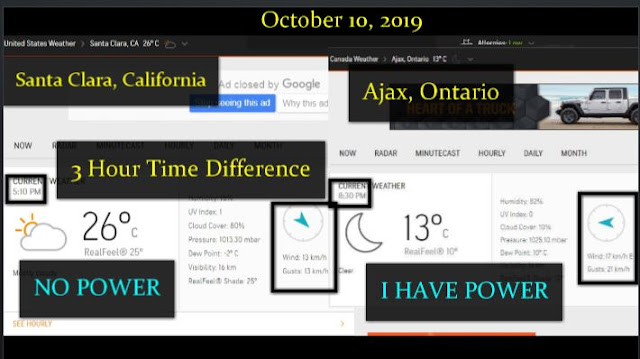
I am leaving this comment on my replies @Global Agenda “I am more then pissed off at this (none) ‘WIND EVENT’ they are calling it and it never happened. Total FEAR PORN and one big MIND GAME they (The Rothschild’s) are playing in conjunction with the NWO on the residents of California. I kept track of seven cities that had power cut to them today by PG&E from 9am until 5pm California time. (3 hours behind me) NOT ONE reached any amount of WIND EVENT that they are talking about. In fact I kept track of my town (Ajax) here just east and outside of Toronto and we were windier then all but one of the 16 readings that I took. Only Alameda was windier this evening then Ajax, Ontario. As per ACCUWEATHER.This is a scam. My video will be out tomorrow.”
Definitely bs.. They do the same hype up&fear mongering with the possibility of fires on the same excessive level that they do for the possibility of hurricanes on the east coast…They manipulate&control us with FEAR Much love Mark lookin forward to seeing what you put together
And the mainstream media wants to justify that it was okay.
Update 10/11/19
CALIFORNIA IS PUTTING A STOP TO HAM RADIO OPERATORS! HAM RADIOS ARE ONE OF THE FEW METHODS THAT IS STILL AVAILABLE TO HELP PEOPLE STAY INFORMED IN EMERGENCIES WHEN CELL PHONES, COMPUTERS AND TELEVISION NO LONGER WORK!
UPDATE!! The State of California has heard you and is working to fix the situation I will be doing an update to this story as soon as I get an official response from the state government. Thank you all for participating in government. Read the letter here: http://www.shastadefense.com/FAX-CalF… Read the Sheriff’s response http://www.shastadefense.com/Sheriffe…
What Is Really Going On In California? Over 500,000 Without Power Already And A Week Of Darkness Ahead Could Deliver Chaos, But Is More At Play Than Meets The Eye?
Series Of Earthquakes At Top Secret California Naval Compound Ongoing To This Day
(ANP -All News Pipeline: We will be both updating and doing follow ups on this story over the next week as new information arrives.)
Within a period of just a few hours Tuesday morning, ANP received several different emails from a number of different friends of the website surrounding the same general subject matter so we just had to take a look at what’s now happening in the state of California. As this story at KPRC in Houston reports, millions of Californians could be without power for an entire week as the power company PG&E shuts off power due to fire risk as we also hear in the 1st video at the bottom of this story.
With potentially 2 million affected and over 60 schools expected to be closed in Northern California where deadly wildfires could be triggered by brutal weather coming ashore off of the Pacific Ocean, Pacific Gas & Electric announced Monday it may shut off power this week in nearly 30 northern California counties in response to strong and dry winds posing a fire threat.
“We would encourage residents and businesses to prepare for being without power for potentially as long as seven days,” San Jose Mayor Sam Liccardo said in a press conference Monday night.
Urging residents to shelter in place while encouraging families to create emergency plans and kits which include food and water for all family members and pets, the ‘strongest offshore wind event of the year‘ could potentially bring a rapid spread of wildfires over very large areas in California had the National Weather Service warning residents there: “The time to prepare is now“.
Yet with that major windstorm coming in as early as 5 a.m. Wednesday morning and expected to last for at least a couple of days, triggering widespread fires that could last for weeks, shouldn’t ‘the time to prepare‘ have been yesterday and the past few weeks/months/years? Anybody’s who has been through a big East coast snow storm knows that the very worst time to prepare is when everybody else is doing so in a last gasp rush as well.
So while we’ll pray for the people of Northern California who may soon witness an inferno roaring through, as ANP reader ‘Remie‘ who lives there mentioned Tuesday in a comment on this ANP story, “Yesterday afternoon we were told it would be 2-7 days. Today we got a call saying 5-7 days, starting this evening, and it could be longer. Then we find out it could affect water pumping stations and some people could be without water. This forced blackout could affect over 2 million people, mostly in Northern California but also some in Southern California. I just hope nothing “weird” happens during this time frame that so many people in the state have no power.“
And as we’ll explore within the rest of this story, these wildfires that could whip up havoc aren’t the only ‘events of chaos‘ happening in California now with a still ongoing series of earthquake aftershocks that could very well number near a million at China Lake and what appears to be major censorship surrounding them.
(UPDATE #1: According to Power Outage US as seen in the graphic below, as of 3:48 p.m. on Wednesday, more than 520,000 Californian’s have already lost power! That number will fluctuate over the next week as this event unfolds.)
According to this August 21st story over at the US Navy Intelligence News website, the Navy’s top secret China Lake Weapons facility may take years to become fully operational again following a pair of strong earthquakes that struck the Navy’s key hub for air warfare research, development and testing six weeks ago handed the service a huge bill to replace, rebuild or repair damaged facilities. Their story estimates that repairs will cost over $5 billion in total.
While their story admits to more than 26,000 aftershocks following the pair of strong quakes that struck the Navy’s mega-secret compound back in July of this year, the so-called ‘aftershocks‘ still continue to this day with October 4th the 3 month anniversary of the 6.4 quake that struck the Ridgecrest, California on July 4th, followed the next day by a devastating 7.1 quake.
The following two quotes come to us from a video which this Global Research story strongly recommends we watch, a video that we’ve embedded as the 2nd video at the bottom of this story, a 45 minute History Channel documentary titled “The Invisible Machine: Electromagnetic Warfare – HAARP – Microwave Weaponry“.:
“Electromagnetic weapons … pack an invisible wallop hundreds of times more powerful than the electrical current in a lightning bolt. One can blast enemy missiles out of the sky, another could be used to blind soldiers on the battlefield, still another to control an unruly crowd by burning the surface of their skin. If detonated over a large city, an electromagnetic weapon could destroy all electronics in seconds. They all use directed energy to create a powerful electromagnetic pulse.”
“Directed energy is such a powerful technology it could be used to heat the ionosphere to turn weather into a weapon of war. Imagine using a flood to destroy a city or tornadoes to decimate an approaching army in the desert. The military has spent a huge amount of time on weather modification as a concept for battle environments. If an electromagnetic pulse went off over a city, basically all the electronic things in your home would wink and go out, and they would be permanently destroyed.”
So with China Lake being one of the most highly secret and important US military bases in the manufacture of Naval Air Weapons and the area it is in seemingly under sustained ‘seismic attack‘ with an endless series of aftershocks lasting over three months now, is it really out of the realm of possibility that some kind of tectonic weaponry might be being used against China Lake, with modern day technologies such as ‘pulse wave generators‘ offering the perfect ‘stealthy‘, sneak attack?
As this story at Brobible pointed out, following the July 4th/5th monsters, the scientists over at the Foley Art Center in Alabama put out a tweet “the Cali earthquake’s epicenter wasn’t just “near” the Naval weapons base at China Lake. IT WAS THE EPICENTER. It occured 1 mile directly beneath it” while a former pro ballerina suggested via tweetthere is little doubt that someone doesn’t want us to know about the “tectonic weapons” being unleased underground at the United States Navy’s largest single landholding, covering more more than 1,100,000 acres in Southern California.
And while we have no proof at the moment that the Naval Weapons Reseach Compound at China Lake, California is under ‘tectonic weapon attack‘ as some have suggested, as Michael Snyder had reported in this October 1st story at End of the American Dream titled “Signs Of The Times? Earthquake Swarms Hit Texas, Oklahoma, San Francisco AND The New Madrid Fault Zone“, “the concern is that all of this shaking could be leading up to something. I wrote about this potential danger a few days ago, and scientists assure us that “the Big One” is way overdue and that at some point our time will run out.”
And with the Pacific Northwest Seismic Network recently reporting a major slow slip event hinting the Cascadia Subduction Zone might also be preparing to blow as Ethan Huff had reported in this Natural News story, helping to show that it’s not only California that is ‘shaking, rattling and rolling‘ but much of the West Coast, it’s been reported that millions could die should a series of devastating quakes strike the many vulnerable faults along the West Coast, and possibly leading to the meltdown of several nuclear powers that are already in disrepair.
The midwest flooding also hit a number of ranchers and their livestock, so either meat shortages or spikes in prices for some meats can also be expected, and no, I am not going to suggest raising your own cattle, but it might come in handy to have some freeze dried or canned meats to add to your homegrown vegetables.
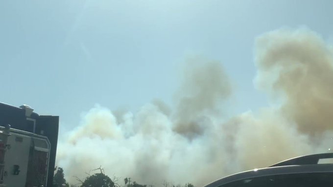
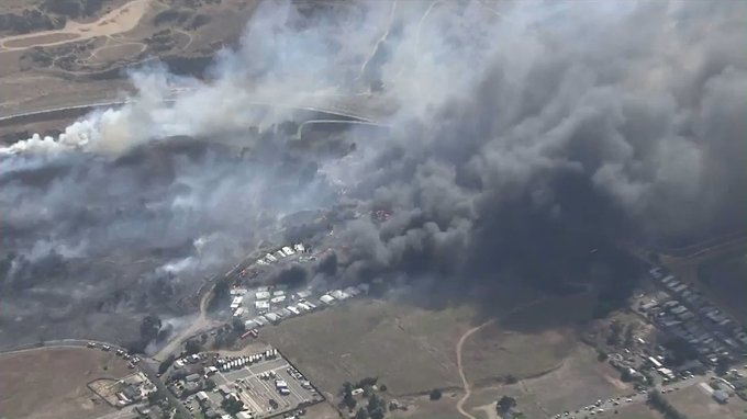
New fires are being reported in California, with some fires worsening due to recent Red Flag warnings, dry climates, and gusty winds. In fact, red flag conditions were so severe that power had to be cut off by PG&E to hundreds of thousands of people in the state. Here’s a look at the latest wildfires for October 10, 2019, including the Briceburg Fire, the new Wendy Fire, the Reche Fire in Moreno Valley, the Sandalwood Fire in Calimesa, and more. This article first includes interactive maps for all of California, including Cal Fire and other sources. Then the second section details specific fires in the region in alphabetical order. Details like evacuations can change quickly, so stay tuned to your local news sources. This story will provide links to where updates will be posted for fires, when available.
Interactive Maps of California Fires
Here are interactive maps you can follow to get the best updates about California fires in October. In many cases, the fires don’t always overlap on these maps, so it’s good to review all of them for the latest information.
One of the best interactive maps available right now is Inciweb’s map. You can see the full map here. There’s an embeddable Google Map that includes Inciweb fires which you can see below. Depending on your browser, you may need to zoom in using the + button within the map or change settings to only show Inciweb fires:
Another good map can be found here from Ca.gov. A screenshot is below since the map can’t be embedded, but you’ll want to go to the full map for details. You can input your address to see how close the fires are to your location.
Ca.gov
A new interactive fire map is below, provided by UCANR.edu. Note that this map is only updated up to twice daily, so it may not be not as current as the two interactive maps above.
Newer fires may not be listed on the above maps until they’ve been around for a few hours.
Next are more specific details on the fires for October 10, 2019. If you are looking for a specific fire, search for the name so you can find it faster, or just scroll down and look at the fires, listed in alphabetical order.
List of Active Fires in California on October 10, 2019
Here are the active fires and updates about them. Most of these are in alphabetical order.
Bautista Fire
This fire is 167 acres and 100 percent contained as of October 8, according to Inciweb. The cause is under investigation. It was within the South Fork Wilderness.
Briceburg Fire
PCPFire@PCP_FIRE
Patrol-57 from Chicago Park Fire and its crew have been extremely busy on the #BriceburgFire, with strike team 5002 Foxtrot. The team also includes Ceres Fire, Wood Lake Fire, @TulareCoFire Orange Grove Fire, and our strike team leader from @ClovisFire#MariposaCounty#pcpfire
This is the biggest fire in the region right now. It started on October 6 and has grown quickly. It’s now 4,900 acres and 25 percent contained, up from 10 percent containment yesterday. The fire is in Mariposa County. The following interactive map is provided by MappingSupport.com.
Ca.gov noted: “Overnight firefighters made good progress towards containment. Efforts today will remain focused on fireline construction and strengthening contingency lines. Evacuation orders and advisories remain unchanged from previous updates. Yosemite National Park remains open. For information on Yosemite National Park, go to nps.gov/yose or call 209-372-0200.”
Mandatory Evacuations:
According to Ca.gov, mandatory evacuations include addresses on Highway 140 between Octagon Road and Colorado Road
Bug Hostel
All of Buffalo Gulch Road and Briceburg Campground
All the same mandatory evacuations from yesterday are still in place as of 10 a.m. Pacific, according to Ca.gov.
Evacuation Advisories: The following are under advisories but not mandatory orders, according to CA.gov:
Colorado Road from Highway 140 to Davis Road
All of Davis Road
Highway 140 from Colorado Road to Midpines Market
Ponderosa Way including all side roads: Deer Park, Leichtlin Lane, Feliciana Mountain Road
Rancheria Creek Road
Rumley Mine Road
Evacuation Centers:
New Life Christian Fellowship, 5089 Cole Road, Mariposa, CA 95338
Small Animal Shelter: SPCA of Mariposa County 5599 CA-49, Mariposa, CA 95338
(209)966-5275
Large Animal Shelter: Contact Mariposa Animal Control, (209)966-3615
A new fire that doesn’t have an official name started in the Brisbane region today. The fire is off Guadalupe Canyon Parkway in Brisbane and started near 11 a.m. on Thursday, KTVU reported.
You can watch a live video feed of the fire above. The fire is on San Bruno Mountain.
Broder Fire
InciwebBroder Fire
This fire is 381 acres in size and 100 percent contained as of October 9. It was started by lightning on August 8. It’s northeast of Broder Meadow. Inciweb noted: “What heat remain is located deep within the perimeter of the fire and will continue to produce smoke for the time being.”
Caples Prescribed Fire
Prescribed burns are purposefully set to help decrease the possibility of unexpected, damaging fires in the future. This one is in the northern ridge region above Caples Creek north of Highway 88.
Cattle Fire
This fire is 92 acres and 100 percent contained as of October 9, according to Inciweb. It’s located in the “Kern River Ranger District SQF. 1 mile east (up river) from the Powerhouse (Bakersfield end)on Hwy. 178 between Bakersfield and Lake Isabella.”
On October 8, Ca.gov noted about the fire: “Firefighters will continue to monitor the fire to ensure it stays within control lines. Containment will steadily increase as crews further secure control lines by identifying and extinguishing sources of heat along the fire perimeter.”
The fire’s burning in the Golden Trout Wilderness on Inyo National Forest. The fire’s being successfully confined and suppressed. Inciweb released its final official update on the fire on September 7, although it’s still listed as active on Ca.gov’s website. They wrote:
The 1,975-acre Cow Fire remains 30 percent contained. Minimal smoke may be visible from the Cow Fire until the area receives significant rainfall. Firefighters will continue to monitor the fire to ensure it stays within control lines. Containment will steadily increase as crews further secure control lines by identifying and extinguishing sources of heat along the fire perimeter.
The ecosystem within the Cow Fire footprint will benefit from the low-intensity fire effects observed on the landscape. Lightning-caused wildfires have a natural role to play in Eastern Sierra forest ecosystems…
The public is encouraged to avoid the fire area. Post-fire hazardous such as fire weakened trees and burning stump holes may be present.”
September 7 was the final Inciweb update for the fire due to good suppression efforts.
Cross Fire
Ca.gov
This fire started on October 9 around 6:52 a.m. It’s in Monterey and San Luis Obispo Counties and is 289 acres and 90 percent contained, according to Ca.gov. (It’s up from 30 percent containment yesterday.) The fire is in yellow on the map above.
The fire is located on Indian Valley Road and Monterey County Line, near Camp Robert’s.
#EagleFIRE CORRECTION: Public Information Officer, PIO 1 responding.
CAL FIRE Riverside
✔@CALFIRERRU
#EagleFIRE [Update 1:30 PM] Forward spread stopped. Resources will remain on scene as they work to fully contain/control the fire. The cause of the fire is under investigation.
Forward spread has been stopped on the Eagle Fire, which started on October 10. The cause is under investigation. This Riverside County fire’s information sheet is here.
The fire grew to about 25 to 30 acres. The information sheet says there is currently no containment, but Cal Fire noted that forward spread is stopped and resources remain on the scene to fully contain the fire. The fire is southeast of Corona in Riverside County, off Eagle Canyon Road and Cajalco Road.
Evans Creek Fire
This fire is 25 acres and now 100 percent contained as of September 27, though it’s still listed as active on Inciweb’s map. It’s southwest of Reno, Nevada.
Fork Fire
Inciweb
This fire started on September 8 in the early evening, caused by lightning. It’s at Middle Fork Parker Creek, in South Warner Wilderness. The fire is currently 39 acres in size as of September 15, which is the last Inciweb update. The map above is the most recent map for the fire.
Inciweb noted: “The Fork Fire in the South Warner Wilderness is a full suppression fire being managed using tactics that will have a low impact and maintain wilderness character. The fire has burned 39 acres of primarily dead and downed fuels. Fire activity has been minimal as the fire slowly consumes surface fuels.”
Klamath NF Fall RX Burning
These are prescribed burns in the Klamath National Forest area to cut down on damage from unplanned fires.
Lowe Fire
This fire is 10 acres and 100 percent contained as of September 25, according to Inciweb. It’s still listed on Inciweb’s map. It was near Loma Alta and Chaney Trails.
Merrill Fire
Ca.govMerrill Fire
This fire is in Contra Costa County and was just discovered on October 10 around 6:42 a.m. It’s 40 acres and 95 percent contained, according to Ca.gov and Cal Fire. The fire is located near Merrill Circle N. and Merrill Dr. in Moraga.
Middle Fire
Inciweb
The Middle Fire is 1,339 acres as of October 6 and now listed as 100 percent contained according to Inciweb. It was located one mile east of Canyon Creek Trailhead and was caused by lightning. It started on September 5 and is in the Trinity Alps Wilderness. “Please be aware that the forest’s Middle Fire Closure Order remains in effect until the fire is declared out.”
Plains Fire
CAL FIRE
✔@CAL_FIRE
#PlainsFire off Millville Plains Road and Sprig Road in Millville in Shasta County is 20 acres. Forward spread stopped.
This fire is off Millville Plains Road and Sprig Road in Millville, located in Shasta County. It’s 20 acres but forward spread has stopped.
Ramshorn/SHF Lightning Fires 2019
The lightning fires from storms that moved into the area in September are now 100 percent contained and declared out, according to Inciweb.
Ranch Fire
This fire is listed on Ca.gov as having started on October 1 in Sal Luis Obispo. It’s off Pozo Road and Avanales Ranch Road, southeast of Pozo, and is overseen by the Los Padres National Forest. No further details were provided.
Reche Fire in Moreno Valley
The Reche Fire was just discovered on Thursday, October 10 near Reche Canyon Road and Jordan Drive in Moreno Valley. The fire is in Riverside County and is now 350 acres in size and 10 percent contained, Riverside County updated at 6:30 p.m. Pacific. It’s in the 9000 block of Reche Canyon Road, according to Riverside County and burning at a moderate rate of speed. High tension power lines in the area may be threatened.
CA Fire Scanner@CAFireScanner
#RecheFire (N/O Moreno Valley) – AA310 reports fire is now 100 acres, IC previously reported potential for an extended attack.
Mandatory evacuations were issued for areas near the fire, but all evacuation orders for the Reche Fire were lifted as of 9 p.m. Pacific on October 10, Riverside County noted.
Reche Canyon Drive from Reche Vista to Locust Drive will be open only to residents.
Large and small animals can be taken to the San Jacinto Valley Animal Campus at 581 S. Grand Avenue in San Jacinto if evacuations are needed. Call 951-358-7387 if you need help.
A care and reception center is located at Canyon Springs High School.
Riverside County has an information sheet here with the latest updates on evacuations and other details.
Updates are also being provided on Cal Fire Riverside’s Twitter account.
10/10/2019 @ 2:05 PM – [UPDATE] The fire is now 100 acres and 0% contained. CAL FIRE/Riverside County Firefighters responded to reports of a trailer fire with extension to the vegetation. The first…
rvcfire.org
CAL FIRE Riverside
✔@CALFIRERRU
#RecheFire [UPDATE] – 2:30 pm Mandatory Evacuations on Reche Canyon Road, east of Reche Vista Drive and west of Locust Avenue.
#SandalwoodFire (#Calimesa) has an immediate threat to Mesa View Middle School at end of Sandalwood Drive, they’re requesting evacuation ASAP by local PD. Incident Command is at Bob’s Big Boy.
The Sandalwood Fire fire started on October 10 and has already caused extensive damage to a mobile park in the region called Villa Calimesa Mobile Home Park. The fire also poses a threat to the railway and power grid. A total of 74 structures were destroyed as of 8 p.m. Pacific on October 10, according to Riverside County.
The fire started when a trash truck dumped a load of burning trash, which then spread to the nearby vegetation, Riverside County noted.
A nearby school (Mesa View Middle School) was also threatened by the fire. The fire is now 500 acres and 10 percent contained as of 8 p.m., according to Riverside County.
#Wildfire: Public safety personnel are implementing immediate evacuations in the area of Sandalwood Drive and Seventh Street in Calimesa, where a wildfire is out of control, threatening numerous structures. Updates to come. : @TonyNBCLA
The fire was described as being near the region of Calimesa Boulevard and Sandalwood Drive. The map below gives you a basic idea of where the fire is, but it’s not an exact location.
RT CAL_FIRE “RT CALFIRERRU: #SandalwoodFIRE: Evacuation ORDERS in place South of 7th street, East of Countyline Rd. Map provided by Riverside County Emergency Management Department. pic.twitter.com/kQ6Trnnsfo“
A care and reception center is located at the Calimesa Senior Center at 908 Park Avenue in Calimesa. This center closed at 7:30 p.m.
Evacuation centers are in the following areas:
Mesa Grande Academy at 975 Fremont Street, Calimesa, CA (opened at 7:30 p.m. on October 10. Transportation will be provided to evacuees at the Senior Center.)
Large and small animals can be taken to the San Jacinto Valley Animal Campus at 581 S. Grand Avenue in San Jacinto. If residents need help getting their pets there, they can call 951-358-7387.
Yupaica-Calimesa News reported on the fire, indicating this is the Yupaica fire that some have been tweeting about. You can see their video of the fire below.
(Note: Cal Fire on Twitter refers to this as the Sandlewood fire, but Riverside County spells it Sandalwood.)
Schaeffer Fire
This fire is 297 acres and 100 percent contained as of October 9. It was caused by lightning and located southwest of Coral Meadow on the Kern Plateau, according to Inciweb. It was within the old 2002 McNally Fire perimeter.
Shasta-Trinity Prescribed Fires
These are prescribed fires in the Shasta-Trinity National Forest area used to mitigate damage from unplanned fires in the future.
Sherman Prescribed Burn
Prescribed burns are purposefully set to help decrease the possibility of unexpected, damaging fires in the future. These are in the Giant Forest area of Sequoia National Park.
Simi Valley Fire (Yosemite Fire)
AI6YR@ai6yrham
·
#YosemiteFire Updated image from the #hamradio#mesh camera, lots less smoke. Units on scene earlier said they can handle and cancelled all additional resources.
AI6YR@ai6yrham
#YosemiteFire looks pretty out, no smoke. My last update.
A one-acre fire is being fought in Simi Valley on EB 118 near Yosemite Avenue. Details are scarce about this fire so far, except that it is a brush fire and units on the scene have said they can handle the fire.
This is not a fire at Yosemite, but on Yosemite Street. It appears to be under control, according to reports. But stay tuned to local news if you are in the area.
South Fire
South Fire
The South Fire started in Shasta-Trinity National Forest in Tehama County, located in the southeast aspect of Tomhead Mountain, south of Platina. As of October 9, the fire is now 5,332 acres in size and 62 percent contained, according to Inciweb. The fire is 15 miles south of Platina, California. The map above is the most recent map for the fire.
Inciweb notes: “The South Fire is in the Shasta-Trinity National Forest, southeast of Tomhead Mountain, west of Red Bluff, and 15 miles south of Platina, CA. The fire is in a remote and very rugged area of the forest. The western portion of the South Fire, within the Yolla Bolly Wilderness, continues to be confined south of Humbolt Ridge; east of Sanford Ridge; and north of Cottonwood Creek. The eastern portion of the fire has completed containment line. HUNTER AND VISITOR INFORMATION ADVISORY: The Shasta-Trinity National Forest has issued a new Forest Closure Order No: 14-19-07. See the closures and maps tab for closure area information or go to: PDF of South Fire Closure Order 14-19-07.”
Springs Fire
This fire is now 4,840 acres and 100 percent contained according to Inciweb on October 7, the last update. It was caused by lightning. It’s located 13 miles southeast of Lee Vining.
Taboose Fire
InciwebFire map from September 24, the most recent map
This fire is 10,296 acres and 75 percent contained as of October 7, the most recent update on Inciweb. It’s southwest of Big Pine and northwest of Aberdeen. It was caused by lightning.
Inciweb noted: “The Taboose Fire has shown some interior smoke in the past several days along the western flank, where warming and drying of unburned fuels has allowed fire activity to increase. Currently, there are a few acres of active fire at high elevation, confined by rocks and burned areas. However, on the northern side of the active fire, there is an area of unburned fuels that the fire could grow into. With wind predicted on Tuesday, it is anticipated that the fire will remain active in this area…
Visitors and residents will see smoke, especially along the Hwy. 395 corridor. Please do not report the smoke. Currently, the south, east, and north flanks are secure and there is no threat to life or property.Gusty wind and low relative humidity are in the forecast for this week and fire crews will continue to monitor and patrol in areas where the fire is active.”
Walker Fire
Inciweb
This fire was first reported on September 4 and the cause isn’t known. On October 7, according to Inciweb, the fire is now 54,608 acres and 100 percent contained. It’s located east of Genesee near Indian Creek and Beckworth Genesee Road.
If you’re in Plumas County, you can sign up for emergency notices here. Or call 530-616-8625 for updates.
Wendy Fire in Newbury Park
The Wendy Fire started late in the day on October 10. It’s located off Potrero Road and S. Wendy Drive in Ventura County’s Newbury Park. The fire is 91 acres in size as of nearly 11 p.m. on October 10.
CAL FIRE PIO
✔@CALFIRE_PIO
#RT@CAL_FIRE: #WendyFire off Potrero Rd and S Wendy Dr, Newbury Park in Ventura County is 91 acres. Lead agency: @VCFD
The Satwiwa Native American Culture Center and the ‘Ap (a replica of a traditional Chumash dwelling) were saved from the fire.
Santa Monica Mtns
✔@SantaMonicaMtns
Satwiwa Native American Culture Center and our ‘Ap (a replica of a traditional Chumash dwelling) have been spared. Nice work, fire crews! #santamonicamountains#wendyfire
All Newbury Park schools, including Banyan Elementary, are currently expected to be open on October 11. Follow the Conejo Valley USD Twitter for updates.
Conejo Valley USD@ConejoValleyUSD
As of 10:40pm all Newbury Park Schools, including Banyan Elem., are scheduled to be open tomorrow, Friday, October 11th. We continue to monitor the #WendyFire closely & be in active communication w/ local agencies. We are thankful to the @VCFD for their bravery & ongoing efforts.
Officials are saying that they are making good progress on this fire.
Michael Coons@Michael_Coons
A couple photos from the #Wendyfire in #newburypark. Last update from VCFD was 91 acres. VCSO copters still making drops but fire is looking good from Potrero Rd. @TOAcornNews
Extreme winds and hot, dry weather have California on edge as they’ve combined to fuel several wildfires across the state. Utility companies have intentionally cut power to over a million people to prevent more fires. Jonathan Vigliotti reports.
About a million people in Northern California are without electricity as the state’s largest utility pulled the plug to prevent a repeat of the past two years when windblown power lines sparked deadly wildfires.


: @TonyNBCLA


 :
: 


18 hours ago
18 hours ago