This year has been a record-breaking year for many things, especially weather. The MidWest has been inundated with flooding, wind and Tornado damage. The farmers have already lost so much of their livestock and may have to watch many more of them die. They have lost the stored crops and have no hope of a crop for this current growing season. They have lost their homes, their personal automobiles, their work vehicles, their outbuildings. They have lost everything. Please keep them in your prayers.
Meanwhile, pray for our nation. There are some very scary times just up ahead. When there are no jobs and no food…people will become desperate. Desperate people take desperate actions. Beware and be safe.
Below are the updates posted over the last 6 months for your review.
Update 8/20/19
NewScientist (excerpts posted here, you can see the entire article by clicking on the link.)
If this concrete is damaged, the water flowing down the spillway can rapidly erode the earth underneath, and there is a risk of the entire dam wall collapsing.
Not all countries have such regular inspection regimes. In the US, it varies widely from state to state. California has a relatively strict regime but astoundingly Alabama doesn’t require inspections of its 2300 dams.
Globally there have been at least 40 dam failures since 2000, resulting in hundreds of deaths. The most recent was the failure of the Tiware dam in India on 2 July after heavy rains, killing at least 19 people. The worst was in 1975, when an estimated 170,000 died after the failure of the Banqiao dam in China.
GBRA leaders cite safety concerns, while community members are afraid dewatering the lakes will have a devastating affect on the economy.
Update 6/19/19
Please pray for the folks who are protesting in Sacramento TODAY. They are up against the establishment and that is a scary place. My hats off to those brave souls and I pray that God gives them favor with everyone.
Join Susan Wolding and Paul Preston today on the steps of the capital in Sacramento, California at 3pm and support the best group of truthers on the Internet today! Thank you, Marty Visit our Official Website for Real-time Monitoring:http://OrovilleDamWatch.com This video is for education purposes and should be taken seriously. All data presented is factual and true according to what we receive straight from the CDEC.
GET OUT WHILE YOU CAN! THEY ARE CLEARING UNDER THE EMERGENCY SPILLWAY! SNOW MELT IS COMING! DON”T HESITATE- GET OUT NOW! Fire Season is here. no work was done on the Tunnels, no work was done on the Gates, we have underground seepage under the Weir and did you see them finish all the drainage on the Main Spillway? The gravel used around the pipes is the wrong size and will flow into the pipes eventually because they can! We saw them put in the underground drainage pipes for the seepage under the Weir, so now we know the truth! There is seepage under the Weir! Remember the Non-Sinkhole? OKAY……. No work was done on the Power Plant leaking and it is working on only 5 turbines. And the biggest question! Where the hell is all the water going to go after it goes down all those steps????!!! Now we can see two ports, but the water will still travel down the tree covered mountain and clog up the diversion pool with trees and debris. The Green Spot is still there and worse, there is liquefaction next to the Spillway and the Spillway is messed up again, please see my new video for proof. Okay! So, I’m here streaming again. I work full time, so depending on if they have the Cams on or not if we will be able to see. I will try. Time schedule on Cams. My family and friends live in the path of the water if this thing comes down, so that is why I am broadcasting this, for them and you! I take no donations and I am not monetized to make money off this channel. But! I am going to Oroville and if you want to help out with my trip expenses then go here and thank you! Paypal.me/susanwoldingstudios If this stream goes down, go to Scalar Glow
Proof of problems at the Oroville Dam and why you should move from under the Dam. This info is from the Dam Experts, inspectors and builders of Dams. Scott Cahill, Paul Preston, Robert Bea and Johnson, and others. Please, I don’t make money doing this, I am just doing it for you!
It certainly isn’t over for the Oroville Dam and the California DWR could end up coming clean with the public about what is “truly” wrong with the facility at large. People know that everything is far from okay, so we can cut the crap and keep it real in here. Marty
The main spillway at the Oroville Dam is cleared of construction related items and is now ready for possible use in the future, though many do not fully trust the spillway’s integrity, nor that of the DWR or Kiewit Construction (and Mining). There is definitely a lot of leaks and other issues with this dam, no doubt about it and not up for discussion on this end, that is why the chat is disabled. You can go naysay on someone else’s video, but we are trying to bring the people of Oroville and downstream areas some very important information that just might save their lives. More to come on this “Project Horseshoe”. God bless, Marty Visit our Official Website for Real-time Monitoring: http://OrovilleDamWatch.com
Update 6/3/19
They released water from a dam in South Dakatoa that will end up in the Missouri River, stating confidently that it will take 6 days to get there and by then the flooding in the Missouri should be down. WHERE DO THEY THINK IT IS GOING TO GO???
San Francisco Bay drains water from approximately 40 percent of California. Water from the Sacramento and San Joaquin rivers, and from the Sierra Nevada mountains, flow into Suisun Bay, which then travels through the CarquinezStrait to meet with the Napa River at the entrance to SanPabloBay, which connects at its south end to San Francisco Bay. Wikipedia
The biggest danger zone lies in the Central Valley at the base of the Sierra Nevada, whose tall peaks can wring the skies of huge amounts of rain and snow. The area is essentially one giant floodplain that would be easily transformed into an inland sea without man-made flood control. At 400 miles long and 40 miles wide, it has only a tiny bottleneck from which to drain— a one-mile opening at the Carquinez Strait at San Pablo Bay — before water heads into the San Francisco Bay.Source
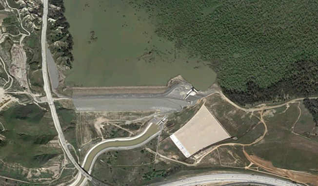
LA Times reports that earlier this month, the 78-year-old Prado Dam was assessed by government officials and engineers. And after taking a look at the aging structure, the U.S. Army Corps of Engineers raised the dam’s risk category from “moderate” to “high urgency.” This means that the next “significant flood event” could potentially breach the Prado Dam’s spillway, thereby possibly flooding local Riverside and Orange County communities from Disneyland Resort in Anaheim all the way to Newport Beach.
The Prado Dam is located adjacent to the 91 Freeway nearby Riverside and Orange counties. For most of the year, the dam holds little to no water. But during significantly rainy seasons or in times of damaging storms, the structure is intended to collect water and prevent flooding along the Santa Ana River, which runs throughout southern California. If nearly-100-year-old structure breaks or is badly damaged in the next big rain storm, the consequences could be dire.
“Our concern right now is about the concrete slab of the spillway and how well it will perform if water were to spill over the top of the dam,” said Lillian Doherty, the Army Corps’ division chief. Source
EMBED <>MORE VIDEOS A patriotic mural is being removed from the Prado Dam as part of a modernization project.
CHINO HILLS, Calif. (KABC) — The 74-year-old Prado Dam in Chino Hills was originally built for flood control to protect San Bernardino County from mountain runoff, and now a $2.3 billion modernization has reconfigured the dam for multiple uses.
“The number on capacity that we have here for the dam is for flood control, that’s our primary mission. So if we did have a flood threat we’ll make sure that we do have sufficient capacity to handle that flood,” said David Van Dorpe with U.S. Army Corps of Engineers. “Right now there’s not very much water behind our dam. We’re hoping that we do get a little more rain here in the spring before we go into the dry summer months.”
The drought has not produced much runoff to store water, but once the project is complete the dam will be able to store most of the rainfall and runoff.
In the years past, much of it would flow from the Santa Ana River down to the ocean, engineers said.
But the Prado Dam is best known for its patriotic mural, which was painted in 1976. It can be seen on the 91 Freeway traveling through Corona.
Upon closer inspection, the mural is faded, damaged by weather and defaced with graffiti. Dam engineers said the mural will have to be removed.
“When it was originally painted in 1976, they used lead-based paints. We can’t risk getting that lead-based paints either into our environment, or our water supply, or to the ocean so the mural it does have to come down,” Dorpe said.
A public hearing on the mural will be held at Corona High School on April 9. The removal process will begin at the end of April.
Sep 3, 2022 The goal is to have the mural “completely restored, hopefully, by July 4 of 2023.” Peter Usle, from the Friends of the PradoDamMural which is leading fundraising efforts — said five city councils — Corona, Eastvale, Norco, Chino and Chino Hills — signed resolutions “in support of returning the mural to its former glory.” “Not …
About 1.4 million people and Disneyland are downstream from the dam along the typically dry Santa Ana River
By Associated Press
Published May 17, 2019 at 10:52 AM | Updated at 8:29 AM PDT on May 18, 2019
Army Corps of Engineers An aerial view shows Prado Dam.
WHAT TO KNOW
Prado Dam is located on the Santa Ana River in the city of Corona in Riverside County southeast of Los Angeles
The Santa Ana River bed is typically dry, but water flow can be heavy after winter storms
Work on the Prado Dam spillway will begin in 2021
A recent assessment has raised concern about the potential for failure of the spillway of a flood control dam on a Southern California river where 1.4 million people live and work downstream, according to the U.S. Army Corp of Engineers.
The Corps said Thursday it has changed the risk characterization of Prado Dam from moderate urgency to high urgency. Prado Dam is located on the Santa Ana River in the city of Corona in Riverside County southeast of Los Angeles. Disneyland and 29 cities, including Anaheim, Santa Ana, Orange, Costa Mesa and Newport Beach, are all along the river’s path to the ocean.
The 96-mile river usually has little water flow except during winter storms and the dam is typically dry. The Corps’ report cites concerns about the spillway during a major flood.
“The dam, which is typically dry, has historically operated without incident,” according to the Corps. “It has not experienced a large enough storm to cause water to flow over the spillway.”
The dam, about 30 miles upstream from the Santa Ana River’s confluence with the Pacific, was built in 1941. An assessment this month indicates potential for poor performance of the spillway during a “significant flood event.” Risk areas include Anaheim,
“Our concern right now is about the concrete slab of the spillway and how well it will perform if water were to spill over the top of the dam,” said Lillian Doherty, the Army Corps’ division chief, according to the Los Angeles Times. “We will determine whether or not it is as reliable as it should be.”
Work on the spillway will begin in 2021.
Doherty said her team with work with experts to determine risk-reduction measures.
“Public safety is our number one priority,” said Col. Aaron Barta, commander of the U.S. Army Corps of Engineers Los Angeles District. “The primary objective of the Corps’ Dam Safety Program is to review our dams and ensure resources are prioritized to address the highest risks.”
About 65 percent of the nearly 700 dams managed by the Corps are more than 30 years old. Twenty-eight percent have reached or passed their 50-year design life. The agency has five dam safety classifications, ranging from normal to urgent and compelling.
The Prado Dam analysis in May came more than two years after a dam spillway crisis at the nation’s tallest dam forced evacuations in the Northern California town of Oroville. A concrete spillway at Oroville Dam crumbled during winter downpours in February 2017.
The Corps determined later that year that the Whittier Narrows Dam, a 60-year-old structure about 40 miles west of Prado Dam, was structurally unsafe. Engineers found that storms could cause a premature opening of the dam’s spillway, unleashing water in the direction of more than 1 million people who live along the San Gabriel River floodplain.
It will cost about $600 million to upgrade Whittier Narrows, according to the Corps. (which makes me suspicious that they prefer to just let it collapse.)
5/28/19
Here is another side of the coming crisis in the GOLDEN GATE area. The water about to pour down on Sacramento/San Francisco…has NOT WHERE TO GO!! Now, this video is climate change propaganda, but it does contain some interesting information. Such as all the toxic waste in the Bay about to be exposed. And the already extremely high water levels due to ocean levels rising. The Bay is already in trouble. Next full moon?
Scientists say it’s no secret San Francisco Bay is rising, along with all of the earth’s oceans. The reason — global warming. This rise in sea level will affect everyone who lives, works, or plays near the bay. QUEST asks how high will the Bay rise and when? And what steps can communities take to plan for it?
5/27/19
ANYONE LIVING NEAR THE OROVILLE DAM PLEASE EVACUATE WHILE YOU STILL CAN!! BETTER TO BE SAFE THAN SORRY!
Proof of Spalling in the Walls and Gate House, It’s cracking apart, they can’t use the Main Spillway, so that means it’s going to go over the Emergency Spillway, you can’t risk that! All that dirt and trees below will go into the river and clog it! Get out people! Go somewhere safe! This is not the only problem, there are too many! Leaks, broken parts, Spalling, gatehouse sinking, and more! Watch the video linked below:
These clips have information regarding the Dam and what’s happening right now. Paul Preston visited our chat and these are his words, you have to watch this. Leaving the valley and going to higher ground is a good idea after hearing from Paul, I have no doubt. Watch the video linked below:
WEBBERS FALLS, Okla. — Two barges that broke free along the Arkansas River have struck the dam near Webbers Falls and sunk. The integrity of the dam remains intact. Footage provided by KFOR-TV, Oklahoma City on May 23, 2019
.
UPDATE 5/22/19 pm
Here are some tools you can use to keep an eye on the flooding in your area.
Flash floods and tornadoes strike across Great Plains, abortion rights activists hold protests in all 50 states to ‘stop the bans,’ and Democrats ramp up impeachment talk as ex-White House counsel refuses to testify.
All the facts now exposed. Stop and read the pages, some old and some new. It’s your decision to stay or go, I am just providing information to help you make that decision. I do not get paid, not monetized, no clickbait. Information provided by experts in the field of Dams, BOC reports, observed and other information obtained from concerned citizens. I pray for your safety. Click the Link to view the video:
105313:45 TO WATCH THIS VIDEO ON BITCHUTE CLICK THE TITLE LINK BELOW:
Blocked on youtube: All the facts now exposed. Stop and read the pages, some old and some new. It’s your decision to stay or go, I am just providing information to help you make that decision. I do not get paid, not monetized, no clickbait. Information provided by experts in the field of Dams, BOC reports, observed and other information obtained from concerned citizens. I pray for your safety.
In my previous post, about California water levels, I presented a “bar graph” showing the amount of water currently in California’s reservoirs. However, I thought it’d be interesting to see how this has changed over the course of the last few months, since the state has gotten alot of rain and snow recently. I decided to try and “animate” the graph for the current water year (going back to October 1, 2015) showing how the recent El Nino rain has been filling up the reservoirs in California. Click the “animate” button below the figure and you can use the slider to change the speed of animation as it cycles through the days.
You can really see a few interesting things:
how low the water level is in December
the start of the rains in January, which start to raise the water level
the March precipitation which makes the storage level rise very quickly
Please click on this link to access the up-to-date interactive map. If the map is unavailable, you can find daily information on water levels for Californian reservoirs by clicking here.
I can hardly believe that I am worried about this from 6,500 miles away and yet this is not even being discussed, except by a small number of concerned citizens. They could be labelled as “conspiracy theorists” were it not from an absolute dire report by top forensic engineer, Bob Bea. Such voices always go unheeded by the non-entities that run the show. I also put this in the context of the crumbling infrastructure in the USA. After almost 20 years of constant wars it would take 80 years to correct just the crumbling bridges. That doesn’t take into account all the nuclear power plants and the dams – and the list goes on. Can you recognise a predicament when you see it? *** Everyone In the CA Central Valley Needs to Hear This:The Oroville Dam spillway is damaged beyond repairhttps://robinwestenra.blogspot.com/20…Everyone In the CA Central Valley Needs to Here This https://www.youtube.com/watch?v=shdaY… Bob Bea Takes Us on a Deep Dive Through His Dire Oroville Reporthttps://alumni.berkeley.edu/californi… At our current pace it’ll take 80 years to repair all the structurally deficient bridges in the US, a report findshttps://edition.cnn.com/2019/04/02/us… Looking at U.S. West Coast Weather, Lake Oroville & EQ Report with Margo (May 16, 2019) https://www.youtube.com/watch?v=orgsL… Another Dam Failure In Texas, & Flooding All Over Not Receding, Big Hit To Infrastructure https://www.youtube.com/watch?v=k3-ML… Oroville Dam Rebuild – Live Stream CHAT https://www.youtube.com/watch?v=ZjEO_..
Some of the videos we featured are very recent and others are from 2017, but we are sharing them because the are relevant to what is going on right now. There is way too much secrecy about everything. Regards, Marty Visit our Official Website for Real-time Monitoring: http://OrovilleDamWatch.com
Overview of the reservoirs in the watershed that feeds the Oroville Reservoir in Butte County, California. Information about the forks of the Feather River that flow into Lake Oroville. *** NOTES/CORRECTIONS/ADDITIONAL INFO FOR THIS VIDEO *** When I mentioned the inflows for the flood events of 1997 and 2017, I estimated that inflows to the Oroville Reservoir had been over 250,000 CFS. Actual data is: 1/1/97 ~ Inflows 274,267 CFS 2/9/17 ~ Inflows 190,435 CFS The CDEC pages for the info are at:http://cdec.water.ca.gov/dynamicapp/s… AND http://cdec.water.ca.gov/dynamicapp/Q…* * * * * * * * MORE * * * * * * * * In this video I said that to my knowledge there were no hydropower plants up on the West Branch. One of my viewers (thanks Gary!) stopped by with the following comment: “The West Branch of the Feather does have diversion dams for the many flumes in the area. The West Branch starts at Coon Hollow and below that is the first seasonal reservoir called Snag Lake. It is always a good laugh when you see people fishing there. There is a power house at Nelson Bar that is getting its water from Kunkle Reservoir which is flume fed from West Branch. So actually there is a power house for the West Branch.”
…SUMMARY… Severe storms with very large hail, tornadoes (a few of which could be strong) and damaging wind are expected, mainly across parts of the Plains from Nebraska south into west Texas. A few severe storms with large hail and gusty winds are also possible across southern South Dakota, as well as across parts of Ohio through the Middle Atlantic. …Synopsis… A synoptic trough will continue slowly east through the Rockies Friday. Mid-upper jet within the base of this trough will develop northeast, and the exit region of this feature will emerge over the central High Plains Friday afternoon. An upper ridge will persist over the upper MS Valley region, while a low-amplitude trough advances southeast through the Great Lakes and the Northeast States. At the surface, a lee cyclone will reside within the approaching upper jet exit region over northeast CO, and the dryline will mix east into western portions of the central and southern Plains. By 12Z a cold front should extend from the lower Great Lakes westward into NE where it will stall. Overnight, a Pacific front accompanying a shortwave trough will merge with the dryline across the central and southern Plains. …Central Plains region… Potential exists for a significant severe event across a portion of NE, and a moderate risk will be considered in day 1 updates. However, primary uncertainty this forecast will be how far south the cold front advances and where it will be during peak heating, which will be critical in determining the corridor of the greatest severe threat. The front should stall somewhere across central or south central NE before possibly retreating slowly north as a warm front. Dewpoints generally in the low 60s F should reside in the warm sector beneath very steep (7.5-8 C/km 700-500 mb lapse rates). This setup will favor strong instability with MLCAPE from 2500-3000 J/kg as the boundary layer warms. However, given warm air at the base of the elevated mixed layer, the warm sector will likely remain capped through at least the first half of the day. Elevated storms will probably be ongoing north of the front early with some threat for hail. Initial surface-based storm development may occur by mid-late afternoon near the triple point from northeast CO into southwest NE at the intersection of surface low/front and dryline where convergence and deep mixing, as well as the arrival of deeper forcing for ascent within upper jet exit region, should weaken the cap. These storms should intensify as they develop northeast through the very unstable warm sector along and just south of the front where 40-50 kt effective bulk shear will favor supercells with very large hail. Tornado threat should be maximized from late afternoon through the early evening as the low-level jet strengthens, contributing to increasing hodographs size with 200+ m2/s2 0-1 km storm relative helicity. More isolated supercells may develop southward through western KS. …Southern Plains… With deeper forcing accompanying the shortwave trough remaining well north of the southern Plains during the day, the question remains how much dryline initiation will occur. The warm sector east of the dryline will become moderately to strongly unstable with 2000-3000 J/kg MLCAPE and steep lapse rates. A capping inversion with the elevated mixed layer will limit thunderstorm initiation much of the day. However, strong dryline mixing and convergence may be sufficient to initiate at least isolated storms during the late afternoon or early evening. IF YOUR A NEW VIEWER and you love my weather content, Please Subscribe to my channel to get daily forecasts on a daily basis and I plan on covering hurricane season with my first forecast expected to get released on May 25th, 2019. Also make sure to like the video, comment and ring the bell icon, Thanks for Support, it keeps me moving. Link listed belowhttps://www.youtube.com/channel/UC5C6… Support this Channel on Paterson, link listed below: https://www.patreon.com/DavidSchlotth… Follow me on Social Media Via…… Facebook: https://www.facebook.com/david.schlot… Twitter:https://twitter.com/Weathermandavid Instagram:https://www.instagram.com/davidschlot… Discord: https://discord.gg/vGaxEr Snap-Chat: @David Schlotthauer or davidmeteroligy Check out these 6 YouTube Weather Channels: 1. WeatherNow: https://www.youtube.com/channel/UCp_Z… 2. Insight Weather: https://www.youtube.com/channel/UCCJ_… 3. Adrian’s soccer trick Shots:https://www.youtube.com/channel/UCigX… 4. Global Weather Updates:https://www.youtube.com/channel/UCBvk… 5. Nicholas Barretto:https://www.youtube.com/channel/UCT8R… 6. Justin The weather boy:https://www.youtube.com/channel/UC9Hf…
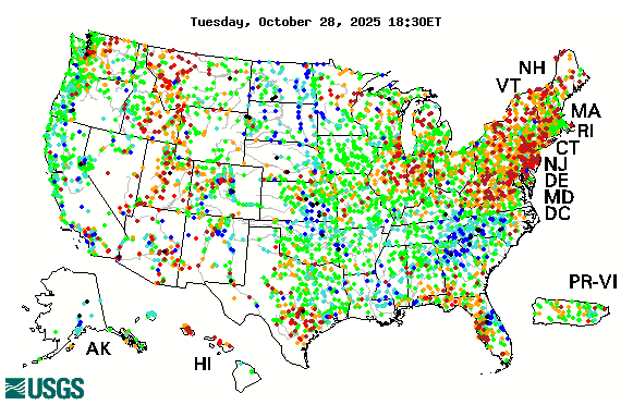
PLEASE NOTE THE NUMBER OF DAMS THAT ARE OVER 90% already, find out the status of dams in your area and keep watch!
https://www.youtube.com/watch?v=QWeks… Should you want to donate, I would very much appreciate it. I have a PayPal account under smilinrocks@gmail.com. Thank you
1732:52 TO WATCH THIS VIDEO ON BITCHUTE CLICK THE TITLE LINK BELOW:
Why are we spending money to help foreign nations build their infrastructure while ours crumbles? Much like we are taking in all the needy of the world and treating our poor and homeless like criminals??? We pay a fortune in innumerable taxes. Our leaders are throwing it away and want us to pay MORE! If we give them more money, you can bet they will just waste it as well. We need to privatize everything and take the power away from the government. We are already paying, we ought to have to choice of where the money goes.
NPR’s Rachel Martin talks to Tom Smith, executive director of the American Society of Civil Engineers, about the current state of the nation’s infrastructure. The group issued a report card in 2017.
RACHEL MARTIN, HOST:
So there is how politicians talk about infrastructure spending, but then there are the people who actually have to build it. Tom Smith represents a lot of those people. He’s the executive director of the American Society of Civil Engineers, and he is in our studios in Washington. Thanks for coming in.
TOM SMITH: Good morning. Thank you, Rachel.
MARTIN: So the American Society of Civil Engineers gave the United States a D-plus rating on the last report card, which came out in 2017. That seems real bad. Why…
SMITH: Absolutely.
MARTIN: …Did the U.S. get that grade?
SMITH: Absolutely. We, unfortunately, have neglected our infrastructure over the years, and much of our infrastructure is nearing the end of its useful life. And we’re at a point now where we cannot kick this can further and further down the road as we’ve been doing for many, many years now. And we need to invest in it. And we’re realizing that maintenance of infrastructure is critical. It’s not just the upfront costs we have to consider. It’s the lifecycle costs, and it’s the maintenance for a developed country like this with an interstate system that was built under Eisenhower back in the 1950s and navigable waterways built in the early 1900s under Roosevelt. We have a lot of work to do.
MARTIN: So we just haven’t been – the U.S. hasn’t been building it, Congress hasn’t been building that kind of maintenance into budgets.
SMITH: Correct. We have not been investing. And I think we really need a national vision for our infrastructure and investment in our infrastructure. We need to be looking towards the future, and not towards the past and relying on our parents and grandparents, the work that they’ve done. We have to look forward and be more sustainable, more resilient, and invest in the future.
MARTIN: Both parties kind of agree in theory that all these fixes need to get made, yet they can’t seem to find the money to invest in them. Why? I mean, in your experience, from your vantage point, what are the stumbling blocks?
SMITH: Absolutely. Well, the good news is that both parties are really talking about this. We saw it in the presidential election. We’re seeing it now in the meeting that’s taking place today. And all the rhetoric that you’re hearing is actually very, very good. The conversation has changed. People are recognizing the problem. And I think the public is recognizing the problem. And polling is showing that, that this is one of the top issues that the public would like to see Congress address in 2019.
So that’s good. How do you pay for it? People who use infrastructure have to pay for infrastructure. That’s us. And in some ways, this needs a…
MARTIN: Taxpayers.
SMITH: ….Culture change. That’s us. That’s all of us. We use infrastructure, and we’ve got to pay for it. One of the things that we talk about is transportation. That’s a big part of the funding gap for infrastructure. Right now, the federal gas tax hasn’t been increased since 1993. It’s 18.5 cents a gallon. It was increased under Clinton. It was increased under H.W. Bush. It was increased under Reagan. But it hasn’t been increased since 1993, and we’re trying to pay for current infrastructure with those dollars.
And in the meantime, we’ve got more fuel-efficient cars. So these dollars are not going as far. So short-term solution, increase the gas tax on the transportation side. I think it eventually will move to sort of vehicle-miles-traveled, as we’re piloting programs to look at that in other states right now.
MARTIN: I imagine you still also, though, need to see a heavy investment by the federal government itself?
SMITH: Absolutely. We’d like to – it needs – it requires an investment in leadership by the federal government, and also investment then by state and local government and the private sector. Those are all the tools in the toolbox that all need to be utilized to solve this problem. But it starts with leadership from the federal government.
MARTIN: You talk about how there is now a public acknowledgement that the infrastructure needs a big boost. It’s probably already pretty dire when that happens. That means the public is noticing. That means that things are breaking, literally, beneath their feet. Can you just quickly tick off what are the worst examples?
SMITH: Absolutely. Right now in the water sector, we have 240,000 waterline breaks a year. So every couple of three minutes, we’re seeing a waterline break. Sometimes that permeates down into…
MARTIN: Every 23 seconds?
SMITH: …Other networks. Every two to three minutes, we’re seeing the waterline break. So we saw that with the Orange Line being delayed last week here in the Metro system. We saw that several years ago that shut down a number of lines of the Metro system here in Washington, D.C.
Transportation. People are sitting in traffic 42 hours average, per year. That’s a vacation period. Now, one of the things we’re also finding is, when we did a study, $3,400 is what an American family pays right now because of our failure to invest in infrastructure. That’s the hidden tax we pay today because of inefficiencies in the system. Sitting in congestion, added cost. We can invest now and save those dollars.
MARTIN: And the meeting will take place today. Maybe it’s a starting point. Tom Smith, executive director of the American Society of Civil Engineers. Thank you for your time. We appreciate it.
I was unable to find a list of tunnels across the USA that are in danger of collapsing. You have to search by state and individual tunnel to find the truth. BUT, I guarantee that if you do research it, you will be horrified. The elite are using our hard earned money to build their underground highways, tunnels, and sanctuaries. They have incredible tunneling equipment they don’t even tell you about. Meanwhile our Tunnels. that millions of Americans pass through every day are so dangerous, they could collapse at any given moment. WAKE UP AMERICA! PLEASE WAKE UP!
I am totally convinced the elite, who decide the fate of the world in their little covert meetings, have decided it is cheaper and easier to destroy the USA, and rebuild “from the Ashes” than to try to fix the issues. How convenient that this also enables them to make significant progress toward their depopulation goals, at the same time. How ironic that all those ILLEGAL IMMIGRANTS pouring into our nation and demanding their free ride, don’t realize they are being led to the slaughter.
Here is the current OROVILLE DAM UPDATE!! May 12th, 2019 Lake Level is at 888-feet Inflows are at 10,500-cfs Outflows are at 9,500-cfs Alert Level is Green So we sent our partner Jesse to Oroville today to take a look around and give us his assessment. Other than driving a black Lambo with Oroville Dam Watch Group painted on the side, I think he kept a pretty low profile! A complete Interview with Jesse Hanlin tomorrow, where he will tell you his scathing story first-hand. You definitely do not want to miss that guys… So I was listening to The Common Sense Show, as I often do, because it just makes common sense, right? That and I like to stay informed and there was on video in particular that I kept going back to because the information is so relevant to what is going on in Oroville and that is the interview that Dave Hodges did with Paul Preston and I really want you guys to hear the complete story. Here is a link to the Original Video I am sharing: https://youtu.be/EkZystT_qqY
“While the opening of Bonnet Carré Spillway caused the river level to drop earlier in the weekend, runoff from the heavy rain caused the Mississippi River at New Orleans to rise briefly back above minor flood stage of 17.0 feet,” AccuWeather Senior Meteorologist Kristina Pydynowski said.
“While levees continue to protect the city at this stage, navigation and docking will remain difficult for boaters,” she said.
The New Orleans Regional Transit Authority temporarily suspended all of its public transportation services Mother’s Day morning, and the NOPD tweeted out a warning against driving through flood water.
Regional Transit Authority@NewOrleansRTA
Our number one priority at @NewOrleansRTA is the safety of our passengers and operators. Due to safety concerns & upon recommendations from @CityOfNOLA Homeland Security, the RTA has temporarily suspended all services. Service will resume as soon as it is safe to do so.
According to the Emergency Manager, Hancock County, Mississippi began evacuating some homes along Road 326 due to flooding along the Wolf River around 9:45 a.m. CDT.
“Much-needed dry weather will span the lower Mississippi Valley this week, but larger rivers will continue to rise and threaten homes and land along their banks,” Pydynowski said.
Heavy overnight rains and floods caused a major freight train derailment in Hillsdale, southwest Mississippi on May 11, 2019. There are no injuries but chemicals are reportedly leaking in the water.
The derailment occurred just north of Hillsdale Road, Pearl River County Sherriff’s Office said.
Hillsdale Road at the train tracks is closed due to flooding and a derailment 0.8km (0.5 miles) north of Hillsdale Road, the office said.
Update 5/12/19
What mainstream weather experts have to say about this storm is only the tip of the iceberg of what’s troubling:
While tropical storms usually gather power from the warm waters of the ocean and then weaken once they move over land, NASA-funded research has shown some storms can actually strengthen over land by drawing from the evaporation of abundant soil moisture. The phenomenon is known as the “brown ocean” effect. ”
Heavy rain and severe flooding is affecting some 22 million Americans Friday morning. Texas and Louisiana seem to be hardest hit, with much of the Houston area left under water. Flash flood watches are up in six states and the rain is expected to last into the weekend. Mireya Villarreal reports.
🔴🔴 Get on our instant Mobile Alert system by texting 555888 with the code word blazingpress for instant notification updates anytime we go live with Major Breaking News 🔴🔴 LIVE ON AIR DONATIONS HERE: https://streamlabs.com/prophetictimes Direct Donation: https://www.paypal.com/cgi-bin/webscr… Join our Patreon community for special events: https://www.patreon.com/trumpetnews 🔴🔴Get on our instant Mobile Alert system by texting 555888 with the code word blazingpress for instant notification updates anytime we go live with Major Breaking News 🔴🔴 Watch Fox News and chat here 24/7: http://www.blazingpress.com
May 10, 2019: ~ Weather Phenom ~ “Biblical Floods” span 100s of miles along Gulf Coast. “Mighty Miss” at FULL capacity! (more water coming in and NO room)https://www.mrmbb333.com
UPDATE 5/10/19
LINK TO LIVE UPDATES: (you can get some visuals at the following sites.)
Multistreaming with https://restream.io/ 🔴🔴 Get on our instant Mobile Alert system by texting 555888 with the code word blazingpress for instant notification updates anytime we go live with Major Breaking News 🔴🔴
Hey guys, here goes Part-1 of a 10-Part Series on “The Crap Yearbook” that should flush all of the rats out of the drain pipes at the Oroville Dam! After everything that I have learned about Kiewit this month, I am wondering if maybe the Graboids are going to eventually rise up and claim their revenge on the dam officials!http://OrovilleDamWatch.com For those of you who have no idea what a “Graboid” is, click here to find out more: https://en.wikipedia.org/wiki/Graboid
OROVILLE DAM UPDATE for May 8th, 2019: As more and more people forward information to us about the Oroville Dam, we realize that our original assessments about the dam were correct and there is a monkey in the machine as we speak. We will reveal him to you as time goes on, but what you need to know for now is that things are not as they appear at the Oroville Dam. More to come tomorrow! Marty VISIT OUR OFFICIAL WEBSITE FOR REAL-TIME MONITORS: http://OrovilleDamWatch.comRELEVANT ARTICLES: https://eventhorizonchronicle.blogspo…https://www.americanthinker.com/blog/.
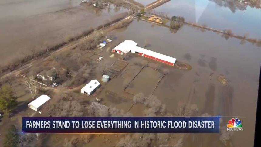
Thousands of farmers in the Midwest have been waiting for a very long time for floodwaters to recede so that they can finally plant some crops, but instead more rain just keeps on coming. As you will see below, it is being reported that the Mississippi River has now been at major flood stage for 41 days in a row, and a lot more rain is coming this week. Meteorologists are warning us that major flooding may extend into June, and that means that many farmers will not be able to plant crops at all this year. Unfortunately, as global weather patterns continue to shift many believe that what we are witnessing this year may become the “new normal” along the Mississippi River.
Researching and pictures of the Oroville Dam and what is going on right now. This is not good news and every one must pass the word, get it out, cause they are taking measures now to use the Emergency Spillway. The Spillway is not in good shape. PLEASE PASS IT ON!!!
As severe spring floods have forced some residents out of their homes in parts of Ontario The Agenda invites experts to discuss how prepared the province is to deal with the new reality of rising waters. Included on the panel with Steve Paikin are Drew Dilkens, mayor of Windsor, and Bonnie Fox, manager of policy and planning at Conservation Ontario.
A suburban Detroit community plans to seek an emergency declaration due to flooding that followed heavy rainfall.
By Associated Press, Wire Service ContentMay 1, 2019, at 5:39 p.m.
A Hanover Street resident surveys the damage along Currier Street following flooding in Dearborn Heights, Mich., Wednesday, May 1, 2019. Overnight rain across the Detroit area lefts scores of basements flooded and made some local streets impassable. Some vehicles had to be towed from the water. (Max Ortiz/Detroit News via AP) THE ASSOCIATED PRESS
DETROIT (AP) — A suburban Detroit community plans to seek an emergency declaration due to flooding that followed heavy rainfall.
Dearborn Heights Mayor Dan Paletko said his office asked the state police Wednesday to consider a declaration and will do a financial assessment of any damage before submitting an official request to the state.
“We’re working on that right now,” Paletko said. “We’ve gone through this before.”
Dearborn Heights is just west of Detroit. Flooding primarily is located in an area referred to as South Dearborn Heights.
“We experienced 3 inches (7.62 centimeters) of rain last night,” Dearborn Heights Fire Chief Dave Brogan told WDIV-TV . “We’ve had several calls of people trapped in their homes who have medical problems or physical limitations that we’re helping … and we’ve had a lot of homes filling up with smoke from water flooding up to their electrical outlets.”
Overnight rain across the Detroit area lefts scores of basements flooded and made some local streets impassable. Some vehicles had to be towed from the water.
The state Department of Transportation said flooding closed the Southfield Freeway in both directions at Outer Drive on Detroit’s west side and the northbound Lodge Freeway in downtown Detroit. Flooding was also reported along Interstate 75 in downtown Detroit.
The National Weather Service issued a flood advisory Wednesday for some communities along the Lake Erie shoreline in southeastern Michigan. The advisory said that southwesterly wind gusts would lead to elevated water levels in Monroe County.
Copyright 2019 The Associated Press. All rights reserved. This material may not be published, broadcast, rewritten or redistributed.
(Reuters) – A swath of heavy rainfall and possible severe weather moving across the central United States on Thursday is threatening to flood several areas where rivers are already swollen from previous rains, the National Weather Service said.
The storms, which may include high winds and possibly hail and tornadoes, could overflow many rivers, including parts of the Ohio and the Mississippi, that are already running higher than average, the weather service said.
“It won’t take much added rain to cause flooding,” said Bob Oravec, a meteorologist at the National Weather Service’s Weather Prediction Center in College Park, Maryland.
Flood watches have been issued in Northern Texas, eastern Oklahoma, northern Arkansas and through the lower Ohio River Valley, which includes parts of Missouri, Illinois, Indiana and Kentucky, Oravec said.
Rainfall in those areas in the past two weeks has been running two to three times above average, he said.
On Wednesday, six tornadoes touched down in areas straddling northern Texas and southern Oklahoma, he added.
The Oklahoma tornadoes killed two people, one in Tulsa and the other in Bokchito, about 150 miles southeast of Oklahoma City, the state’s Office of the Chief Medical Examiner said. Another 22 people were injured, authorities said.
The severe weather, which included up to 6 inches (15 cm) of rain in some parts of Oklahoma, prompted Governor Kevin Stitt on Wednesday to declare a state of emergency for 52 counties.
“The storm system has delivered tornadoes, high winds, and widespread rain since early Tuesday, with damage reported to homes, businesses, outbuildings, trees and power poles,” the state’s Department of Emergency Management reported.
Reporting by Peter Szekely in New York; Editing by James Dalgleish
Severe weather erupted Tuesday across the central United States. Numerous tornadoes touched down in at least five states, with the focus of severe weather fury targeting Oklahoma.
Heavy rain and flooding also were common. Large zones of three or more inches of rain fell across parts of Missouri, Oklahoma, Kansas and Illinois, in particular.
River flooding, which has plagued portions of the central United States since March, was aggravated by Tuesday’s rain. As the Mississippi River surged to near-record levels in parts of Iowa, a flood barrier failed in Davenport and water poured into the city.
More dangerous storms and flooding are predicted for the middle of the nation Wednesday.
Another severe weather volley
More than two dozen reports of tornadoes have been logged for Tuesday. At least a few more reports are likely to trickle in as the National Weather Service investigates the event.
It was the biggest tornado outbreak of the year in parts of the Plains, where places like Oklahoma were hit by numerous tornadoes after a slow start to 2019. The outbreak also caps an active month of weather that featured two large-scale severe weather outbreaks in prior weeks.
From that point through the afternoon and into evening, clusters of tornadic supercells dotted the landscape from Missouri to Texas. After dark, more tornadoes, including a large wedge that did major damage, scoured the landscape in southern Oklahoma as others touched down elsewhere.
On Wednesday, the southern Plains into the ArkLaTex are under the gun for dangerous weather. Another spoke of cold and buoyant air in the fast jet-stream aloft will mix with copious low-level moisture to set off storms across a region, focused on north Texas.
Tornadoes and large hail are possible. Eventually, storms might consolidate into a complex with widespread damaging winds. And with these storms will come more rain.
Flooding now, and beyond
As has been the story for weeks, flooding is ongoing at many locations along the Mississippi River, as well as tributaries to it, and other major waterways across the Midwest and the South.
In Davenport, Iowa, a flash-flood emergency was issued late Tuesday as a flood barrier failed and water poured into the city. Although only a small part of downtown flooded, streets turned to lakes in some sections. The failure was spurred by the Mississippi River rising to near-historic levels. A gauge at Rock Island near the city is poised to threaten levels seen during the 1993 flood on Wednesday before waters subside.
Tuesday’s situation in Davenport is not expected to worsen, as the Mississippi River is heavily contained in most areas.
To the south, an area from Illinois to Oklahoma saw round after round of flash-flood inducing rain Tuesday. Wednesday morning, most of Missouri was under flood warnings as numerous creeks and streams overflowed their banks.
Any additional rainfall is likely to exacerbate it, and more is on the way over the next few days. On Wednesday, a moderate risk for excessive rainfall is focused on the Dallas-Fort Worth area, with a lower but still notable heavy rainfall threat extending into a larger region and then shifting eastward for Thursday.
This latest round of high water should peak in the next few days, with levels falling off thereafter. In many cases, levels dropping still means major flooding ongoing into next week.
The renewed round of flooding comes because the storm train has been running since winter. Signs continue to point to an active period ahead for much of the Lower 48.
With an outlook from the Climate Prediction Center for May that calls for good chances of above-average precipitation in the same regions already experiencing flooding, it’s likely that widespread high water is a story that will persist in the weeks ahead.
And, of course, patterns that cause flooding tend to also bring thunderstorms. May is peak for tornadoes in the United States, as more of the country comes under threat from violent storms.
Flood Threat As mentioned earlier, flash flooding will also be a significant concern in the Plains and Midwest this week. A widespread area of 1 to 3 inches of rainfall is expected from parts of Texas into Michigan. Some areas will see locally higher amounts topping 3 inches, especially where overnight thunderstorm clusters occur. This additional rainfall will increase the chance for flooding this week, especially in areas that receive heavy rainfall in a short period of time. The National Weather Service has issued flood watches for parts of the Plains and mid-Mississippi Valley. River flooding concerns may also increase late this week, as many river gauges along the Mississippi River and in the Midwest are already in at least minor flood stage. The ground is saturated in many locations in this region. Oklahoma City has received more than 4.5 inches of rain in April, and Dallas/Fort Worth has picked up 6.74 inches so far this month, almost 4 inches above average. Storm Reports So Far A line of severe storms roared through parts of Kansas overnight Sunday, producing hail up to baseball-size and damaging winds. Up to 20 power poles were downed by high winds at the Eureka, Kansas, airport, and a semi was blown off U.S. Highway 169 near Greeley, Kansas, injuring the driver.
Spring flooding is starting to overwhelm parts of Ottawa, Montreal and the surrounding areas. Rising waters have closed a major Ottawa bridge and forced more than 5,000 from their homes outside of Montreal.
30/4/2019 Eastern Canada Grapples With Extreme Flooding MONTREAL — Thousands of residents in Quebec, Ontario and New Brunswick were evacuated from their homes after days of flooding that spurred Montreal and Ottawa to declare a state of emergency and promp… #30/4/2019 #Eastern#Canada#Grapples#With#Extreme#Flooding subscribe to Get the fastest news every day.
Hey guys, Thursday April 24th, 2019: We are 23-feet from the Emergency Spillway, meanwhile a lot of people out there are talking smack on the Internet, but that is only because they are butthurt because someone might be making their Golden Boy out to be less than perfect. All that aside, we are here to report the news, so we won’t have time to respond to all of your comments, but we will do our best to stay on top of the comments and respond when we can. Our daily updates will continue, even though I have to go to Los Angeles this weekend to meet with other members of our team. We will keep you updated and our new website will be live very soon, plus we are going to be releasing a free APP for Android and iOS. Have a great weekend! Marty _______________________________________________________ PLEASE SUBSCRIBE TO THESE AWESOME PEOPLE WHO ALSO KNOW THAT SOMETHING IS NOT RIGHT AT THE OROVILLE DAM: BLAZING PRESS CHANNEL:https://www.youtube.com/user/cybertri… TRUMPET NEWS CHANNEL:https://www.youtube.com/channel/UC-vs… SUSAN WOLDING CHANNEL:https://www.youtube.com/user/susanwol… PERTH OBSERVER CHANNEL:https://www.youtube.com/channel/UCciY… THE OTHER SIDE:https://www.youtube.com/user/blancolirio
We have so much information about what is going on at the dam, but rather than confuse people with data, why not connect those data transmitters to software on our new website and make them available for the public to see in real time? That is exactly what we are doing right now! Stay tuned for updates and thank you everyone for your support. Much love, Marty PLEASE THESE WONDERFUL PEOPLE WHO ACTUALLY KNOW THAT SOMETHING IS NOT RIGHT AT THE OROVILLE DAM MAIN SPILLWAY. BLAZING PRESS CHANNEL: https://www.youtube.com/user/cybertri… TRUMPET NEWS CHANNEL: https://www.youtube.com/channel/UC-vs… SUSAN WOLDING CHANNEL: https://www.youtube.com/user/susanwol… PERTH OBSERVER CHANNEL: https://www.youtube.com/channel/UCciY
US to see unprecedented springflooding in coming weeks. More than 200 million people in US are at risk for some kind of flooding in the coming weeks, forecasters say. 21 Mar 2019 20:29 GMT.
SpringFlooding Could Be ‘Unprecedented,’ NOAA Warns NOAA predicts that nearly two-thirds of the continental U.S. will face elevated flood risks through May.
NOAA warns of ‘unprecedented’ springflood season that may become ‘more dire’ in coming weeks. Flooded areas are seen in Bellevue, Neb., on Wednesday. …
The stage is set for unprecedented major flooding this spring for most of the nation, US weather officials said on Thursday. More than 200 million people in the United States are at risk of some kind of flooding, with 13 million of them at risk of major inundation, the National Oceanic and Atmospheric Administration said […]
With yet another snowfall coming this weekend, many are wondering what it’s going to look like in terms of flooding this spring. Public Works says we’ll definitely see some flooding—but how much …
With flooding already reaching historic levels in parts of the United States, federal scientists warn to expect more in the coming months. … could see at least some flooding in the spring, the …
The agency’s 2019 Spring Outlook found that nearly two-thirds of the lower 48 states are at risk for flooding in the coming months. “The extensive flooding we’ve seen in the past two weeks will …
Heavy snow accumulation in many parts of the country means a heightened risk of flooding if the weather turns to spring too quickly. … The big spring thaw is coming: how to protect your home …
The threat of major new flooding on the Missouri River is receding this week, but the stage is set for further disaster as the usual springflood season dawns in the coming weeks. Last week’s …
Submitted by Dave Hodges on Thursday, April 18, 2019 – 12:06.
What Happens If the Dam Collapses?
The experts I speak with tell me, that in the event of a dam collapse, the water will come rushing out at 75 MPH. The water will be 30 feet high. Sacramento would be under water in less than hour. DWS says it would take two hours for the water to reach Sacramento. The point is largely irrelevant. The city could not be successfully evacuated within two hours. Almost two million lives are at risk.
If the dam collapses, the CALEXIT people will realize their goal of eliminating California’s contribution to the nation’s agricultural and world’s supply of food. The affected Central Valley is one of the top suppliers of fruits, nuts and vegetables in the world. Spot famines would result. Further 30% of America’s retail crosses Interstate 15 and that would be stopped immediately and this at a time when the retail collapse of America is already underway with the closing of 6,000 stores in the first quarter of 2019. This event could collapse our economy. And I want to stress that is a preliminary report. I have prepared a summary report below in the following. I will be publishing photos as they arrive and are converted in a publishable format.
“We expect the flooding will get worse and become more widespread,” a National Weather Service official said.
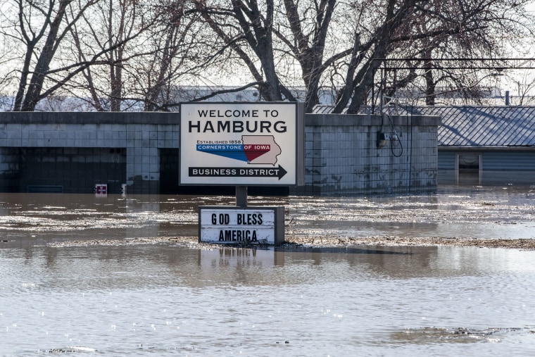
Floodwaters surround businesses and homes in Hamburg, Iowa on March 20, 2019. Water from the swollen Missouri and Nishnabotna Rivers flooded homes, businesses and farmland in the southwest Iowa town.Whitney Curtis / for NBC News
March 21, 2019, 9:38 PM CDT – By Dennis Romero
Late winter’s deadly flooding could turn into catastrophic spring flooding in the Midwest and beyond, forecasters said.
The National Oceanic and Atmospheric Administration’s “spring outlook” issued Thursday came with dire warnings, even as flooding was already tormenting states including Nebraska, Iowa and Missouri. “More than 200 million people are at risk for flooding in their communities,” Ed Clark, director of NOAA’s National Water Center in Tuscaloosa, Alabama, said in a statement.
Three deaths from the Midwest flooding have been confirmed, and on Thursday, President Donald Trump approved Nebraska’s request for federal disaster assistance. The Nebraska National Guard used helicopters Thursday to drop hay bales to feed cows stranded by floodwaters.
Heavy rain supplemented by rapid snow melt has widened rivers and put farms underwater. But Mary C. Erickson, deputy director of National Weather Service, on Thursday warned that the trouble may just be beginning.
“The major flooding we’ve already experienced across the lower Missouri [River region] and the lower to middle Mississippi [River] valley is a preview to what we expect the rest of the spring,” she said. “In fact, we expect the flooding will get worse and become more widespread.”
The outlook states that spring, which this year concludes on June 20, could bring major or moderate flooding in 25 states, with at least two-thirds of the continental United States expected to see an “elevated” flood risk and above-average precipitation.
“Additional spring rain and melting snow will prolong and expand flooding, especially in the central and southern U.S.,” the federal outlook reads. “As this excess water flows downstream through the river basins, the flood threat will become worse and geographically more widespread.”
Erickson said flooding could stretch into May.
“The communities in the high-risk threat areas need to prepare for impacts as the floodwaters move down the river system,” she said.
Jack Boston, senior meteorologist at AccuWeather, said the private forecaster has a similar outlook for spring, with most of the flooding in Missouri and Mississippi river regions likely occurring in April.
Superintendent of the Hamburg Community School District Mike Wells, from right, pulls a canoe out of floodwaters after helping search for a missing cat on in Hamburg, Iowa on March 20, 2019.Whitney Curtis / for NBC News
With as much as 19 inches of snow on the ground in parts of the Dakotas and a lot of snow remaining in western Minnesota, the situation doesn’t bode well, he said: “All that snow has to melt.”
California and Colorado mountains also have above-normal snow pack that has been boosted by a weak El Niño weather condition in the Pacific, he said.
That could contribute to spring avalanches, Boston said.
16 Apr 2019 Corps supports rafters on Westfield River with Littleville, Knightville Dam white water releases in Huntington CONCORD, Mass. – Controlled releases of water are planned by the U.S. Army Corps of Engineers, New England District, from Knightville Dam and Littleville Lake Dam in Huntington, Massachusetts, on Saturday and Sunday, April20-21, 2019 to provide adequate riverflows for …
Front Range, CO: Today, Save The Colorado is sounding a statewide alarm about an apparent effort by the Colorado Water Conservation Board to launch a large-scale “Water Development” strategy to identify to new dam and diversion projects on Front Range rivers.
6 hours ago · Martin Dam opens spillway gates due to heavy rain, full pool Saturday, April20, 201910:46 am. Martin Dam opened two spillway gates Friday as part of Alabama Power’s flood control procedure and .
During a phone interview on April20, Mattison said there are “certainly more” than 100 large damsthat have been built by or for energy companies operating in the region. At the end of the day, he says, additional fieldwork may reveal that there are “200 or more” such facilities.
NASHVILLE, Tenn. (April 5, 2019) – First responders worked through a security scenario at J. Percy Priest Dam today to open communication channels and facilitate awareness of possible threats to infrastructure operated and maintained by the U.S. Army Corps of Engineers Nashville District.
UPDATE 4/4/19
WATCH this weather pattern! Where is all that water going to go? Be prepared! We are already inundated across most of the country. Our Dams and Levees are weak and ready to overflow and/or burst. Batton down the hatches!
Buckle up. God bless everyone, T https://www.paypal.me/thornews mail 5430 Birdwood Rd. #416 Houston, Texas 77096 crankywxguy bloghttp://www.stormhamster.com/entry2/e0…https://weather.com/storms/severe/new…Severe Thunderstorms Possible From the Southern Plains to the Lower Mississippi Valley Midweek A threat of severe thunderstorms is in play in parts of the South the first week of April. The threat begins in the southern Plains Wednesday and Wednesday night. It then migrates into the lower Mississippi Valley Thursday. Large hail and damaging thunderstorm winds are the main threats. However, a few tornadoes are possible. Severe thunderstorms are possible Wednesday and Thursday in parts of the South, ushering in the typical seasonal peak of severe weather in the United States. A jet-stream disturbance currently bringing some rain and mountain snow to the West will swing into the Plains by Wednesday. Ahead of that disturbance, warmer and somewhat more humid air will be pulled northward from the Gulf of Mexico, eroding the colder air in place from early this week. The jet-stream disturbance, cold air topping warmer, humid air and air-lifting surface features such as a dryline and a stationary front should provide the ingredients needed for at least some severe thunderstorms Wednesday into Thursday. We’re not expecting a widespread severe weather outbreak in this case, despite it being the notoriously dangerous month of April, but a few of these storms could be hazardous. Here is our latest forecast. Severe Weather Timeline, Threats Wednesday-Wednesday Night Scattered severe thunderstorms are expected to flare up near the dryline late Wednesday afternoon or early evening in western Oklahoma, perhaps far southern Kansas and far northwestern Texas. This activity may spread eastward into the rest of Oklahoma and parts of Arkansas, North Texas and perhaps far southwestern Missouri Wednesday night. Large hail appears to be the main threat with these storms, though damaging thunderstorm wind gusts are also possible and a tornado or two can’t be ruled out. Thursday, the threat of scattered severe thunderstorms shifts farther eastward, stretching from East Texas and Arkansas into Louisiana, Mississippi, southwestern Tennessee, parts of Alabama and the western Florida Panhandle. Large hail and damaging winds appear to be the primary severe weather threats, but a tornado or two are also possible. Thursday, the threat of scattered severe thunderstorms shifts farther eastward, stretching from East Texas and Arkansas into Louisiana, Mississippi, southwestern Tennessee, parts of Alabama and the western Florida Panhandle. Large hail and damaging winds appear to be the primary severe weather threats, but a tornado or two are also possible.
The flooding that just struck the middle part of the country was the worst blow to U.S. farmers in decades, but now the National Weather Service is telling us that it was just “a preview of what we expect throughout the rest of the spring”. Can that possibly be true? After the immense devastation that we have already witnessed, how much worse can the flooding possibly get? Already we have seen thousands of homes and farms be completely destroyed, and we are being told that the total economic damage is in the billions of dollars. Sadly, the truth is that a lot worse is still yet to come. Thanks to a very snowy winter, a massive amount of snow is going to melt during the next several weeks, and that alone would produce tremendous flooding. But on top of all of that melting snow, forecasters are telling us that it will be a very rainy spring. In fact, the Weather Channel is warning that there will be “above-average precipitation across much of the Lower 48” over the next three months, and one meteorologist is forecasting that it is “not looking like we are going to see any dry stretches anytime soon”. And this is on top of all of the very heavy rainfall that has been falling in recent weeks. At this point, the Mississippi River basin has already gotten “three times as much rainfall as in a normal year”.
Even without any additional flooding, U.S. food production would be way down this year. The recent flooding is going to keep thousands of farmers from planting crops on time, and thousands of others are not going to be able to use their fields at all.
But when you factor in what is going to happen over the next three months, we are talking about an agricultural disaster of unprecedented magnitude in modern American history.
In the eastern Dakotas and Minnesota, more than 20 inches of snow remains on the ground. The Missouri, Ohio, and Mississippi Rivers drain the central United States, but it takes several weeks for the water to travel downstream. In the meantime, emergency officials are warning local residents to make evacuation plans as well as purchase flood insurance in certain areas.
The record-setting floods deluging the Midwest are about to get a lot worse. Fueled by rapidly melting snowpack and a forecast of more rainstorms in the next few weeks, federal officials warn that 200 million people in 25 states face a risk through May.
A lot of people out there seem to think that the flooding will just be isolated to the major rivers, but that is simply not true.
Yes, all-time flooding records will continue to be shattered along the Missouri and Mississippi Rivers, but the National Weather Service is telling us that nearly “the entire eastern two-thirds of the nation” will be dealing with flooding this spring…
Almost the entire eastern two-thirds of the nation should see flooding this spring, National Weather Service deputy director Mary Erickson said at a news conference on Thursday. Some 25 states are forecast to see “moderate” to “major” flooding, the weather service said.
This is the worst case scenario for U.S. flooding that surpasses all previous worst case scenarios. Thousands more farms will be destroyed. Billions of dollars worth of additional damage will be done to our agricultural industry. Food production is going to come up way short, and we are all going to experience tremendous pain at the supermarket as food prices skyrocket.
If you live in any of the following areas, you need to have your emergency plan ready, because things are about to get really, really bad…
The areas under the highest risk of moderate to major flooding, according to NOAA, are the upper, middle and lower Mississippi River basins, including the mainstem Mississippi River, Red River of the North, Great Lakes, eastern Missouri River, lower Ohio River, lower Cumberland River and Tennessee River basins.
U.S. farmers have already lost millions upon millions of bushels of wheat, corn and soybeans to the flooding that has already happened. As I have repeatedly stressed, our planet is changing, weather patterns are becoming more severe, and even if they understood what is happening there is absolutely nothing that the radical environmentalists can do to stop it.
Just look at what is happening on the other side of the world. Australia was just hit by a “severe category 3 cyclone”, and this came exactly one day after it was hit by a category 4 cyclone…
A severe category 3 cyclone blew into the key mining region of Pilbara in Western Australia Sunday, forcing evacuations and a halt to port operations, as the north of the country dealt with the effects of an even more powerful storm that hit the previous day.
Cyclone Veronica weakened from a category 4 storm before its core winds hit the coast near the mining centre of Port Hedland, but officials warned the system was slow moving and would continue pounding the region with gale force winds and heavy rain for 24 to 48 hours.
We are witnessing things that we have never seen before, and “the new normal” is just going to keep getting stranger and stranger.
If you live anywhere in the middle portion of the country, please take this flooding very seriously. Authorities are using apocalyptic language to describe this crisis, and they are not exaggerating the potential threat one bit.
I have included excerpts from each of the articles posted here. You can find the original documents by clicking the title of the article. I recommend that you check them out. They are very well written and informative. Please read all the items here and pay very close attention to the DATES highlighted in red!
U.S. infrastructure is in bad shape. Across the country, streets marred with potholes, overcrowded airports, and out-of-date school facilities have become the norm. But the United States’ failing infrastructure causes more than just commonplace inconveniences. Crumbling infrastructure poses real dangers to Americans’ health and safety, as illustrated by the contaminated water system in Flint, Michigan; flooding due to poor storm water drainage systems in Texas and Louisiana; the failing metro system in Washington, D.C.; and blackouts caused by extreme weather and outdated electrical grids in cities across the country.
A new report from the American Society of Civil Engineers, or ASCE, quantifies how the United States’ chronic underinvestment in infrastructure—spending only half of what is needed—has created an investment gap that affects the economy, safety, jobs, communities, and health. As infrastructure continues to age without proper investment and upkeep, the costs to maintain and repair it continue to rise over time. The report found that if infrastructure deficiencies are not addressed, it could cost the economy almost $4 trillion in gross domestic product, or GDP, and 2.5 million jobs by 2025. In short, policymakers’ short-term cost cuts will cause massive expenses in the long term.
The country’s dam infrastructure is not exempt from this underinvestment. With an ASCE grade of a D, the country’s nearly two million dams are one of the most pressing infrastructure challenges for safety, the environment, and the economy. While most of these dams were originally built for economic purposes—including to power mills and factories developed during the industrial revolution and for flood and debris control, water storage and irrigation, hydropower, navigation, and recreation—many of their original purposes and benefits have diminished. In fact, many dams are now obsolete, costly, aging, and unsafe.
June 2, 2016 – Conservationists can now point to the largest dam removal project in the U.S. as a success story. The ecosystem of Washington’s Elwha River has been thriving since the removal of its hydroelectric dam system. Recent surveys show dramatic recovery, especially in the near shore at the river’s mouth, where the flow of sediment has created favorable habitat for the salmon population. A new generation of salmon species, some of which are endangered, are now present in the river. Some hope that the restoration of the Elwha River will become a shining example for the removal of dams across the U.S.


 13315:09 TO WATCH THIS VIDEO ON BITCHUTE CLICK THE TITLE LINK BELOW:


![[NATL-LA GALLERY] Historic Photos of the Nation's Tallest Dam](https://media.nbclosangeles.com/images/620*446/GR_Oroville_Construction_1853-9_08_30_1963.jpg)
![[LA GALLERY Updated 3/2019] Photos: What It Takes to Repair a Damaged Spillway at the Nation's Tallest Dam](https://media.nbclosangeles.com/images/646*349/3-2019-oroville-dam-spillway-before-after.jpg)

 TODAY NOAA has ranked
 3068:12 TO WATCH THIS VIDEO ON BITCHUTE CLICK THE TITLE LINK BELOW:
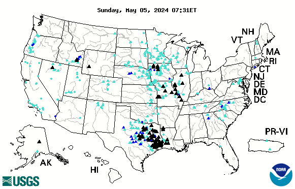

 18533:13 TO WATCH THIS VIDEO ON BITCHUTE CLICK THE TITLE LINK BELOW:
 105313:45 TO WATCH THIS VIDEO ON BITCHUTE CLICK THE TITLE LINK BELOW:
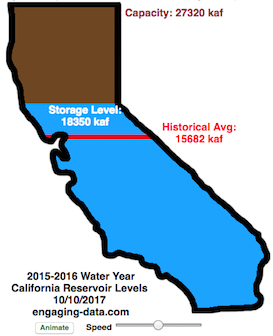

 14314:46 TO WATCH THIS VIDEO ON BITCHUTE CLICK THE TITLE LINK BELOW:
 17835:16 TO WATCH THIS VIDEO ON BITCHUTE CLICK THE TITLE LINK BELOW:
 1732:52 TO WATCH THIS VIDEO ON BITCHUTE CLICK THE TITLE LINK BELOW:


 19334:51 TO WATCH THIS VIDEO ON BITCHUTE CLICK THE TITLE LINK BELOW: